
FCCInfo.com
A Service of Cavell, Mertz & Associates, Inc.
(855) FCC-INFO
|
|
|
|  |
|
|||||||||||||||
|
|
KFRB Channel: 217B 91.3 MHz Bakersfield, California Service: FM - A full-service FM station or application. Facility ID: 20902 Fac. Service: FM Status: License Application Accepted: 08/15/2005 Application Granted: 12/01/2005 File Number: BLED-20050815AAD License Expires: 00/00/0000 Prefix Type: This is a license for a noncommercial educational FM station Application Type: License To Cover FCC Website Links: LMS Facility Details This Application CDBS Application Other KFRB Applications Other KFRB Applications in CDBS Including Superseded Applications Mailing Address Correspondence for KFRB Correspondence related to application BLED-20050815AAD Service Contour - Open Street Map or USGS Map (60 dBu) Service Contour - KML / Google Earth (60 dBu) Public Inspection Files Facility Type: NON-COMMERCIAL EDUC. FM Class: B, A Zone I or I-A station; with 25kW-50kW ERP and a class contour distance 39km-52km Site Location: 35-26-16.8 N 118-44-25.3 W (NAD 83) Site Location: 35-26-17.0 N 118-44-22.0 W (Converted to NAD 27) Effective Radiated Power: 0 kW Horiz. ; 2.8 kW Vert. Transmitter Output Power: 0.794 kW Antenna Center HAAT: 0 m Horiz.; 417 m Vert. Antenna Center AMSL: 0 m Horiz.; 1132 m Vert. Antenna Center HAG: 0 m Horiz.; 58 m Vert. Site Elevation: 1074 m. (3524 ft.) Height Overall*: 88 m (289 ft.) (* As Filed In This Application, may differ from ASR Data, Below.) Directional Antenna Antenna Make/Model: Shivley 6513-1-DA Antenna ID: 66507 Polarization:
| ||||||||||||||||||
| Antenna Data for Antenna Id: 66507 KFRB FM File: BLED-20050815AAD Shivley - 6513-1-DA Service: FM | 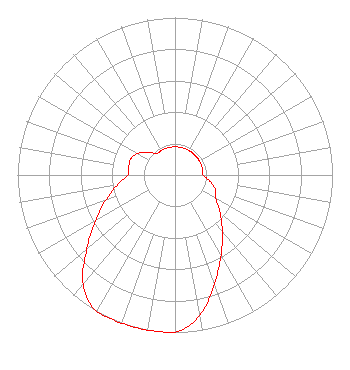 | ||||||||||||||||||
| Azimuth | Ratio | Azimuth | Ratio | Azimuth | Ratio | Azimuth | Ratio | ||||||||||||
| 0 | 0.179 | 10 | 0.179 | 20 | 0.179 | 30 | 0.179 | ||||||||||||
| 40 | 0.179 | 50 | 0.179 | 60 | 0.179 | 70 | 0.179 | ||||||||||||
| 80 | 0.179 | 90 | 0.179 | 100 | 0.224 | 110 | 0.274 | ||||||||||||
| 120 | 0.299 | 130 | 0.373 | 140 | 0.467 | 150 | 0.586 | ||||||||||||
| 160 | 0.732 | 170 | 0.906 | 180 | 1.000 | 190 | 1.000 | ||||||||||||
| 200 | 1.000 | 210 | 1.000 | 220 | 0.906 | 230 | 0.732 | ||||||||||||
| 240 | 0.586 | 250 | 0.467 | 260 | 0.373 | 270 | 0.299 | ||||||||||||
| 280 | 0.299 | 290 | 0.299 | 300 | 0.274 | 310 | 0.224 | ||||||||||||
| 320 | 0.179 | 330 | 0.179 | 340 | 0.179 | 350 | 0.179 | ||||||||||||
Structure Registration Number 1015947 Structure Type: LTOWER Registered To: Nexstar Media Inc. Structure Address: Nr Breckenridge Rd 25.7 Km Ene Bakersfield, CA County Name: Kern County ASR Issued: 05/28/2021 Date Built: 08/01/1967 Site Elevation: 1074.4 m (3525 ft.) Structure Height: 60.9 m (200 ft.) Height Overall: 87.7 m (288 ft.) Overall Height AMSL: 1162.1 m (3813 ft.) FAA Determination: 11/04/2014 FAA Study #: 2014-AWP-6884-OE FAA Circular #: 70/7460-1J Paint & Light FAA Chapters: 3, 4, 5, 13 PRIOR STUDY 1997-AWP-473-OE. OM&L to remain the same as prior study = PAINT/RED LIGHTS 35-26-17.1 N 118-44-26.3 W (NAD 83) 35-26-17.3 N 118-44-23.0 W (Converted to NAD 27) |
112 North Elm Street Shenandoah, IA 51601 Phone: 712-246-5151 Corporation | Date: 08/15/2005 Application Certifier FAMILY STATIONS, INC. 4135 Northgate Blvd., Suite 1 Sacramento, CA 95834 Applicant LINDA ADAMS 4135 Northgate Blvd., Suite 1 Sacramento, CA 95834 TECHNICAL CONSULTANT ALAN C. CAMPBELL, ESQ. Irwin, Campbell & Tannenwald, P.c. | |||||||||||||||||