
FCCInfo.com
A Service of Cavell, Mertz & Associates, Inc.
(855) FCC-INFO
|
|
|
|
|
||||||||||||||||
|
|
K292FF Channel: 292D 106.3 MHz Terrell Wells, Texas Service: FX - A translator or application for a translator. Facility ID: 138666 Fac. Service: FX Programming Delivery Method: Unspecified Status: License Application Accepted: 03/29/2007 Application Granted: 04/10/2007 File Number: BLFT-20070329ADQ License Expires: 08/01/2029 Prefix Type: This is a license for a translator Application Type: License To Cover FCC Website Links: LMS Facility Details This Application CDBS Application Other K292FF Applications Other K292FF Applications in CDBS Including Superseded Applications Mailing Address Correspondence for K292FF Correspondence related to application BLFT-20070329ADQ Service Contour - Open Street Map or USGS Map (60 dBu) Service Contour - KML / Google Earth (60 dBu) Class: D, A Noncommercial educational operating with no more than 10W Site Location: 29-27-34.8 N 98-24-25.1 W (NAD 83) Site Location: 29-27-34.0 N 98-24-24.0 W (Converted to NAD 27) Effective Radiated Power: 0 kW Horiz. ; 0.15 kW Vert. Transmitter Output Power: 0.216 kW Antenna Center HAAT: 0 m Horiz.; 96.6 m Vert. Antenna Center AMSL: 0 m Horiz.; 310 m Vert. Antenna Center HAG: 0 m Horiz.; 99 m Vert. Site Elevation: 211 m. (692 ft.) Height Overall*: 118 m (387 ft.) (* As Filed In This Application, may differ from ASR Data, Below.) Directional Antenna Antenna Make/Model: Scala FMV Antenna ID: 31326 Polarization: H
| ||||||||||||||||||
| Antenna Data for Antenna Id: 31326 K292FF FX File: BLFT-20070329ADQ Scala - FMV Service: FX Pattern and Field Values Include a 230° Clockwise Rotation | 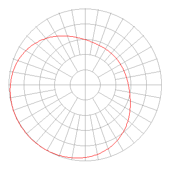 | ||||||||||||||||||
| Azimuth | Ratio | Azimuth | Ratio | Azimuth | Ratio | Azimuth | Ratio | ||||||||||||
| 0 | 0.592 | 10 | 0.566 | 20 | 0.549 | 30 | 0.540 | ||||||||||||
| 40 | 0.535 | 50 | 0.534 | 60 | 0.535 | 70 | 0.540 | ||||||||||||
| 80 | 0.549 | 90 | 0.566 | 100 | 0.592 | 110 | 0.630 | ||||||||||||
| 120 | 0.679 | 130 | 0.735 | 140 | 0.792 | 150 | 0.845 | ||||||||||||
| 160 | 0.892 | 170 | 0.929 | 180 | 0.956 | 190 | 0.975 | ||||||||||||
| 200 | 0.987 | 210 | 0.995 | 220 | 0.999 | 230 | 1.000 | ||||||||||||
| 240 | 0.999 | 250 | 0.995 | 260 | 0.987 | 270 | 0.975 | ||||||||||||
| 280 | 0.956 | 290 | 0.929 | 300 | 0.892 | 310 | 0.845 | ||||||||||||
| 320 | 0.792 | 330 | 0.735 | 340 | 0.679 | 350 | 0.630 | ||||||||||||
Structure Registration Number 1220126 [ASR Heights Differ from K292FF Application] Structure Type: GTOWER Registered To: American Towers LLC Structure Address: 510 Petroleum Dr. (374550) San Antonio, TX County Name: Bexar County ASR Issued: 09/01/2023 Date Built: 02/15/2001 Site Elevation: 210.9 m (692 ft.) Structure Height: 108.5 m (356 ft.) Height Overall: 109.7 m (360 ft.) Overall Height AMSL: 320.6 m (1052 ft.) FAA Determination: 08/29/2023 FAA Study #: 2023-ASW-12313-OE FAA Circular #: 70/7460-1K Paint & Light FAA Chapters: 4, 8, 12 OM&L to remain the same as prior study = A MED-DUAL SYSTEM 29-27-34.9 N 98-24-25.5 W (NAD 83) 29-27-34.1 N 98-24-24.4 W (Converted to NAD 27) |
4002 N. 3300 E. Twin Falls, ID 83303 Phone: 208-734-6633 Not-for-Profit | Date: 03/29/2007 Application Certifier CALVARY CHAPEL OF TWIN FALLS, INC. Po Box 391 Twin Falls, ID 83303 Applicant LOIS MILLS Po Box 391 Twin Falls, ID 83303 APPLICATIONS TECHNICIAN CARY S. TEPPER, ESQ. Booth, Freret, Imlay & Tepper, Pc 7900 Wisconsin Ave, Suite 304 Bethesda, MD 20814-3628 | |||||||||||||||||