
FCCInfo.com
A Service of Cavell, Mertz & Associates, Inc.
(855) FCC-INFO
|
|
WGNC-FM from 12/18/2012 |
|
|
||||||||||||||||
|
|
WGNC-FM Channel: 203B1 88.5 MHz Constantine, Michigan Service: FM - A full-service FM station or application. Facility ID: 173002 Fac. Service: FM Status: License Application Accepted: 01/04/2013 Application Granted: 01/29/2013 File Number: BLED-20130104ACE License Expires: 00/00/0000 Prefix Type: This is a license for a noncommercial educational FM station Application Type: Amendment FCC Website Links: LMS Facility Details This Application CDBS Application Other WGNC-FM Applications Other WGNC-FM Applications in CDBS Including Superseded Applications Mailing Address Correspondence for WGNC-FM Correspondence related to application BLED-20130104ACE Service Contour - Open Street Map or USGS Map (60 dBu) Service Contour - KML / Google Earth (60 dBu) Public Inspection Files Facility Type: NON-COMMERCIAL EDUC. FM Class: B1, A Zone I or I-A station; with 6kW-25kW ERP and a class contour distance 28km-39km Site Location: 41-53-51.2 N 85-33-51.0 W (NAD 83) Site Location: 41-53-51.0 N 85-33-51.0 W (Converted to NAD 27) Effective Radiated Power: 15 kW Transmitter Output Power: 4.14 kW Antenna Center HAAT: 108 m (354 ft.) Antenna Center AMSL: 361 m (1184 ft.) Antenna Center HAG: 102 m (335 ft.) Calculated Site Elevation: 259 m. (850 ft.) Height Overall*: 129 m (423 ft.) (* As Filed In This Application, may differ from ASR Data, Below.) Directional Antenna Antenna Make/Model: Aldena ALP.08.02.712-Slant(40)-DA Antenna ID: 110895 Polarization: | ||||||||||||||||||
| Antenna Data for Antenna Id: 110895 WGNC-FM FM File: BLED-20130104ACE Aldena - ALP.08.02.712-Slant(40)-DA Service: FM | 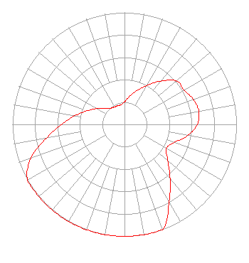 | ||||||||||||||||||
| Azimuth | Ratio | Azimuth | Ratio | Azimuth | Ratio | Azimuth | Ratio | ||||||||||||
| 0 | 0.201 | 10 | 0.253 | 20 | 0.319 | 30 | 0.401 | ||||||||||||
| 40 | 0.505 | 50 | 0.605 | 60 | 0.614 | 70 | 0.653 | ||||||||||||
| 80 | 0.673 | 90 | 0.650 | 100 | 0.573 | 110 | 0.472 | ||||||||||||
| 120 | 0.432 | 130 | 0.503 | 140 | 0.633 | 150 | 0.797 | ||||||||||||
| 160 | 1.000 | 170 | 1.000 | 180 | 1.000 | 190 | 1.000 | ||||||||||||
| 200 | 1.000 | 210 | 1.000 | 220 | 1.000 | 230 | 1.000 | ||||||||||||
| 240 | 1.000 | 250 | 0.891 | 260 | 0.708 | 270 | 0.562 | ||||||||||||
| 280 | 0.447 | 290 | 0.355 | 300 | 0.282 | 310 | 0.224 | ||||||||||||
| 320 | 0.190 | 330 | 0.179 | 340 | 0.178 | 350 | 0.178 | ||||||||||||
Structure Registration Number 1267803 Structure Type: TOWER Registered To: Impact Radio, LLC Structure Address: North Side Of Fairchild Road, 0.1 Mi East Of Engle Road Centreville, MI County Name: St. Joseph County ASR Issued: 04/02/2009 Date Built: 09/25/2009 Site Elevation: 259.1 m (850 ft.) Structure Height: 128 m (420 ft.) Height Overall: 128.9 m (423 ft.) Overall Height AMSL: 388 m (1273 ft.) FAA Determination: 03/30/2009 FAA Study #: 2009-AGL-1360-OE FAA Circular #: 70/7460-1K Paint & Light FAA Chapters: 4, 6, 12 PRIOR STUDY 2008-AGL-2431-OE 41-53-50.8 N 85-33-50.6 W (NAD 83) 41-53-50.6 N 85-33-50.6 W (Converted to NAD 27) |
P.o. Box 1793 Elkhart, IN 46515 Phone: 888-800-9940 Not-for-Profit | Date: 01/04/2013 Application Certifier CHRISTIAN RADIO FRIENDS, INC. P.o Box 1793 Elkhart, IN 46515 Applicant ROBERT MOORE 1908 Sweetbriar Drive Goshen, IN 46528 CONSULTING ENGINEER MATTHEW H. MCCORMICK Fletcher, Heald & Hildreth, P.l.c. | |||||||||||||||||