
FCCInfo.com
A Service of Cavell, Mertz & Associates, Inc.
(855) FCC-INFO
|
|
WQYZ from 11/11/1994 WQYZ from 07/02/1992 |
|
|
||||||||||||||||
|
|
WQYZ Channel: 223A 92.5 MHz Ocean Springs, Mississippi Service: FM - A full-service FM station or application. Facility ID: 24513 Fac. Service: FM Status: License 73.215 Station Application Accepted: 01/18/2001 Application Granted: 10/26/2001 File Number: BLH-20010118ABJ License Expires: 00/00/0000 Prefix Type: This is a license for a commercial FM station Application Type: Amendment FCC Website Links: LMS Facility Details This Application CDBS Application Other WQYZ Applications Other WQYZ Applications in CDBS Including Superseded Applications Mailing Address Correspondence for WQYZ Correspondence related to application BLH-20010118ABJ Service Contour - Open Street Map or USGS Map (60 dBu) Service Contour - KML / Google Earth (60 dBu) Public Inspection Files Facility Type: FM STATION Class: A, A Zone I; I-A; or II station; with 0.1kW-6kW ERP and a class contour distance <=28km Site Location: 30-27-09.7 N 88-51-21.1 W (NAD 83) Site Location: 30-27-09.0 N 88-51-21.0 W (Converted to NAD 27) Effective Radiated Power: 6 kW Transmitter Output Power: 2.8 kW Antenna Center HAAT: 98 m (322 ft.) Antenna Center AMSL: 104 m (341 ft.) Antenna Center HAG: 91 m (299 ft.) Site Elevation: 13 m. (43 ft.) Height Overall*: 98 m (322 ft.) (* As Filed In This Application, may differ from ASR Data, Below.) Directional Antenna Antenna Make/Model: Propagation System Inc PSIFM-3-DA Antenna ID: 15847 Polarization: | ||||||||||||||||||
| Antenna Data for Antenna Id: 15847 WQYZ FM File: BLH-20010118ABJ Propagation System Inc - PSIFM-3-DA Service: FM | 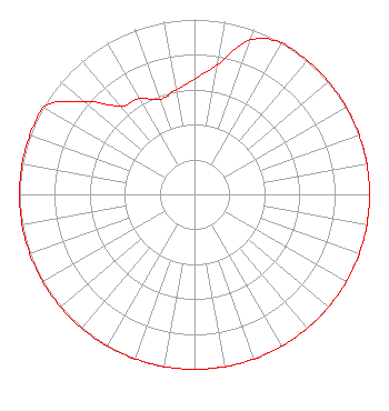 | ||||||||||||||||||
| Azimuth | Ratio | Azimuth | Ratio | Azimuth | Ratio | Azimuth | Ratio | ||||||||||||
| 0 | 0.658 | 10 | 0.753 | 20 | 0.940 | 30 | 1.000 | ||||||||||||
| 40 | 1.000 | 50 | 1.000 | 60 | 1.000 | 70 | 1.000 | ||||||||||||
| 80 | 1.000 | 90 | 1.000 | 100 | 1.000 | 110 | 1.000 | ||||||||||||
| 120 | 1.000 | 130 | 1.000 | 140 | 1.000 | 150 | 1.000 | ||||||||||||
| 160 | 1.000 | 170 | 1.000 | 180 | 1.000 | 190 | 1.000 | ||||||||||||
| 200 | 1.000 | 210 | 1.000 | 220 | 1.000 | 230 | 1.000 | ||||||||||||
| 240 | 1.000 | 250 | 1.000 | 260 | 1.000 | 270 | 1.000 | ||||||||||||
| 280 | 1.000 | 290 | 1.000 | 300 | 1.000 | 310 | 0.827 | ||||||||||||
| 320 | 0.658 | 330 | 0.632 | 340 | 0.577 | 350 | 0.606 | ||||||||||||
Structure Registration Number 1054437 [ASR Heights Differ from WQYZ Application] Structure Type: GTOWER Registered To: American Towers LLC Structure Address: 14806 Big Ridge Road (002957 / Desoto) Biloxi, MS County Name: Jackson County ASR Issued: 02/01/2024 Date Built: 05/18/1998 Site Elevation: 12.5 m (41 ft.) Structure Height: 95.1 m (312 ft.) Height Overall: 97.8 m (321 ft.) Overall Height AMSL: 110.3 m (362 ft.) FAA Determination: 02/16/2023 FAA Study #: 2022-ASO-16355-OE FAA Circular #: 70/7460-1K Paint & Light FAA Chapters: 4, 8, 12 PRIOR STUDY 2003-ASO-6331-OE 30-27-11.7 N 88-51-26.0 W (NAD 83) 30-27-11.0 N 88-51-25.9 W (Converted to NAD 27) |
7136 S. Yale Avenue Suite 501 Tulsa, OK 74136 Phone: 918-664-4581 | Date: 01/18/2001 Application Certifier GOLDEN GULF COAST BROADCASTING, INC. 9994 Rodriguez Street Suite G Biloxi, MS 39535 Applicant CHARLES A. COOPER 201 Fletcher Avenue Sarasota, FL 34237 TECHNICAL CONSULTANT | |||||||||||||||||
| |||||||||||||||||||