
FCCInfo.com
A Service of Cavell, Mertz & Associates, Inc.
(855) FCC-INFO
|
|
|
|
|
||||||||||||||||
|
|
W294CL Channel: 294D 106.7 MHz Charleston, West Virginia Service: FX - A translator or application for a translator. Facility ID: 201510 Fac. Service: FX Programming Delivery Method: Unspecified Status: License Application Accepted: 05/10/2018 Application Granted: 07/26/2018 File Number: BLFT-20180510AAO License Expires: 00/00/0000 Prefix Type: This is a license for a translator Application Type: License To Cover FCC Website Links: LMS Facility Details This Application CDBS Application Other W294CL Applications Other W294CL Applications in CDBS Including Superseded Applications Mailing Address Correspondence for W294CL Correspondence related to application BLFT-20180510AAO Service Contour - Open Street Map or USGS Map (60 dBu) Service Contour - KML / Google Earth (60 dBu) Class: D, A Noncommercial educational operating with no more than 10W Site Location: 38-21-25.0 N 81-36-21.0 W (NAD 83) Site Location: 38-21-24.6 N 81-36-21.6 W (Converted to NAD 27) Effective Radiated Power: 0.099 kW Transmitter Output Power: 0.237 kW Antenna Center HAAT: 0 m Antenna Center AMSL: 367 m (1204 ft.) Antenna Center HAG: 30 m (98 ft.) Site Elevation: 337 m. (1106 ft.) Height Overall*: 44 m (144 ft.) (* As Filed In This Application, may differ from ASR Data, Below.) Directional Antenna Antenna Make/Model: None Antenna ID: 129837 Polarization:
| ||||||||||||||||||
| Antenna Data for Antenna Id: 129837 W294CL FX File: BLFT-20180510AAO None - Service: FX | 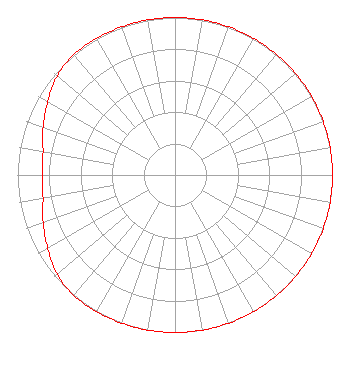 | ||||||||||||||||||
| Azimuth | Ratio | Azimuth | Ratio | Azimuth | Ratio | Azimuth | Ratio | ||||||||||||
| 0 | 1.000 | 10 | 1.000 | 20 | 1.000 | 30 | 1.000 | ||||||||||||
| 40 | 1.000 | 50 | 1.000 | 60 | 1.000 | 70 | 1.000 | ||||||||||||
| 80 | 1.000 | 90 | 1.000 | 100 | 1.000 | 110 | 1.000 | ||||||||||||
| 120 | 1.000 | 130 | 1.000 | 140 | 1.000 | 150 | 1.000 | ||||||||||||
| 160 | 1.000 | 170 | 1.000 | 180 | 1.000 | 190 | 1.000 | ||||||||||||
| 200 | 1.000 | 210 | 1.000 | 220 | 1.000 | 230 | 0.977 | ||||||||||||
| 240 | 0.933 | 250 | 0.891 | 260 | 0.851 | 270 | 0.841 | ||||||||||||
| 280 | 0.851 | 290 | 0.891 | 300 | 0.933 | 310 | 0.977 | ||||||||||||
| 320 | 1.000 | 330 | 1.000 | 340 | 1.000 | 350 | 1.000 | ||||||||||||
Structure Registration Number 1054163 Structure Type: TOWER Registered To: WEST VIRGINIA RADIO CORPORATION DBA = WKWS FM Structure Address: Vaughan Dr Northgate Business Park Charleston, WV County Name: Kanawha County ASR Issued: 08/04/1998 Date Built: 01/01/1969 Site Elevation: 337.1 m (1106 ft.) Structure Height: 42.4 m (139 ft.) Height Overall: 43.9 m (144 ft.) Overall Height AMSL: 381 m (1250 ft.) Paint & Light FAA Chapters: 1, 2 38-21-25.0 N 81-36-21.0 W (NAD 83) 38-21-24.6 N 81-36-21.6 W (Converted to NAD 27) |
1251 Earl L. Core Road Morgantown, WV 26505 Phone: 304-554-3900 | Date: 05/10/2018 Application Certifier WEST VIRGINIA RADIO CORPORATION OF CHARLESTON 1251 Earl L. Core Road Morgantown, WV 26505 Applicant LAURA M. MIZRAHI Communications Technologies, Inc. P.o. Box 1130 Marlton, NJ 08053 TECHNICAL CONSULTANT FRANK R. JAZZO Fletcher, Heald & Hildreth, Plc 1300 N. 17th Street 11th Floor Arlington, VA 22209 | |||||||||||||||||