
FCCInfo.com
A Service of Cavell, Mertz & Associates, Inc.
(855) FCC-INFO
|
|
W261DD from 07/03/1989 |
|
|
||||||||||||||||
|
|
W261DD Channel: 261D 100.1 MHz Springfield, Massachusetts Service: FX - A translator or application for a translator. Facility ID: 66424 Fac. Service: FX Programming Delivery Method: Unspecified Status: License Application Accepted: 10/13/2016 Application Granted: 10/28/2016 File Number: BLFT-20161013AAK License Expires: 00/00/0000 Prefix Type: This is a license for a translator Application Type: License To Cover FCC Website Links: LMS Facility Details This Application CDBS Application Other W261DD Applications Other W261DD Applications in CDBS Including Superseded Applications Mailing Address Correspondence for W261DD Correspondence related to application BLFT-20161013AAK Service Contour - Open Street Map or USGS Map (60 dBu) Service Contour - KML / Google Earth (60 dBu) Class: D, A Noncommercial educational operating with no more than 10W Site Location: 42-05-55.3 N 72-37-43.3 W (NAD 83) Site Location: 42-05-55.0 N 72-37-45.0 W (Converted to NAD 27) Effective Radiated Power: 0.25 kW Transmitter Output Power: 0.163 kW Antenna Center HAAT: 0 m Antenna Center AMSL: 136 m (446 ft.) Antenna Center HAG: 116 m (381 ft.) Site Elevation: 20 m. (66 ft.) Height Overall*: 122 m (400 ft.) (* As Filed In This Application, may differ from ASR Data, Below.) Directional Antenna Antenna Make/Model: None Antenna ID: 125175 Polarization:
| ||||||||||||||||||
| Antenna Data for Antenna Id: 125175 W261DD FX File: BLFT-20161013AAK None - Service: FX | 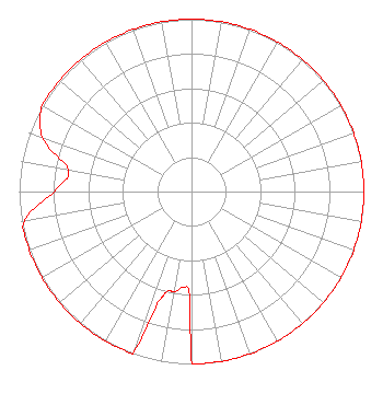 | ||||||||||||||||||
| Azimuth | Ratio | Azimuth | Ratio | Azimuth | Ratio | Azimuth | Ratio | ||||||||||||
| 0 | 1.000 | 10 | 1.000 | 20 | 1.000 | 30 | 1.000 | ||||||||||||
| 40 | 1.000 | 50 | 1.000 | 60 | 1.000 | 70 | 1.000 | ||||||||||||
| 80 | 1.000 | 90 | 1.000 | 100 | 1.000 | 110 | 1.000 | ||||||||||||
| 120 | 1.000 | 130 | 1.000 | 140 | 1.000 | 150 | 1.000 | ||||||||||||
| 160 | 1.000 | 170 | 1.000 | 180 | 1.000 | 181 | 0.600 | ||||||||||||
| 185 | 0.560 | 190 | 0.590 | 193 | 0.590 | 195 | 0.620 | ||||||||||||
| 197 | 0.700 | 200 | 1.000 | 210 | 1.000 | 220 | 1.000 | ||||||||||||
| 230 | 1.000 | 240 | 1.000 | 250 | 1.000 | 260 | 0.986 | ||||||||||||
| 270 | 0.796 | 280 | 0.725 | 290 | 0.920 | 300 | 1.000 | ||||||||||||
| 310 | 1.000 | 320 | 1.000 | 330 | 1.000 | 340 | 1.000 | ||||||||||||
| 350 | 1.000 | ||||||||||||||||||
Structure Registration Number 1058191 Structure Type: TOWER Registered To: Red Wolf Broadcasting Corporation Structure Address: River Street West Springfield, MA County Name: Hampden County ASR Issued: 02/05/2019 Date Built: 06/06/1986 Site Elevation: 19.8 m (65 ft.) Structure Height: 121 m (397 ft.) Height Overall: 121.9 m (400 ft.) Overall Height AMSL: 141.7 m (465 ft.) FAA Determination: 06/05/1986 FAA Study #: 86-ANE-235-OE Paint & Light FAA Chapters: 1, 3, 12, 21 RED LIGHTS/PAINT 42-05-55.0 N 72-37-43.0 W (NAD 83) 42-05-54.7 N 72-37-44.7 W (Converted to NAD 27) |
756 Colonel Ledyard Highway Po Box 357 Ledyard, CT 06339 Phone: 860-883-4292 | Date: 10/13/2016 Application Certifier RED WOLF BROADCASTING CORPORATION 758 Colonel Ledyard Highway P.o. Box 357 Ledyard, CT 06339 Applicant W. JEFFREY REYNOLDS Du Treil, Lundin & Rackley, Inc. 201 Fletcher Avenue Sarasota, FL 34237-6019 TECHNICAL CONSULTANT SCOTT WOODWORTH Edinger Associates Pllc 1875 I Street Nw Suite 500 Washington, DC 20006 | |||||||||||||||||