
FCCInfo.com
A Service of Cavell, Mertz & Associates, Inc.
(855) FCC-INFO
|
|
|
|
|
||||||||||||||||
|
|
KTXK Channel: 218C1 91.5 MHz Texarkana, Texas Service: FM - A full-service FM station or application. Facility ID: 65294 Fac. Service: FM Status: License Application Accepted: 02/24/2004 Application Granted: 03/08/2004 File Number: BLED-20040224AAA License Expires: 00/00/0000 Prefix Type: This is a license for a noncommercial educational FM station Application Type: License To Cover FCC Website Links: LMS Facility Details This Application CDBS Application Other KTXK Applications Other KTXK Applications in CDBS Including Superseded Applications Mailing Address Correspondence for KTXK Correspondence related to application BLED-20040224AAA Service Contour - Open Street Map or USGS Map (60 dBu) Service Contour - KML / Google Earth (60 dBu) Public Inspection Files Facility Type: NON-COMMERCIAL EDUC. FM Class: C1, A Zone II station; with 50kW-100kW ERP and a class contour distance 52km-72km Site Location: 33-23-33.4 N 94-14-44.7 W (NAD 83) Site Location: 33-23-33.0 N 94-14-44.0 W (Converted to NAD 27) Effective Radiated Power: 100 kW Transmitter Output Power: 13.4 kW Antenna Center HAAT: 93 m (305 ft.) Antenna Center AMSL: 183 m (600 ft.) Antenna Center HAG: 91 m (299 ft.) Site Elevation: 92 m. (302 ft.) Height Overall*: 108 m (354 ft.) (* As Filed In This Application, may differ from ASR Data, Below.) Directional Antenna Antenna Make/Model: Shivley 6810-8-.9SS-DA Antenna ID: 46187 Polarization: | ||||||||||||||||||
| Antenna Data for Antenna Id: 46187 KTXK FM File: BLED-20040224AAA Shivley - 6810-8-.9SS-DA Service: FM | 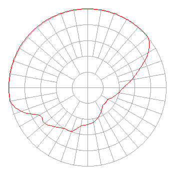 | ||||||||||||||||||
| Azimuth | Ratio | Azimuth | Ratio | Azimuth | Ratio | Azimuth | Ratio | ||||||||||||
| 0 | 1.000 | 10 | 1.000 | 20 | 1.000 | 30 | 1.000 | ||||||||||||
| 40 | 1.000 | 50 | 1.000 | 60 | 0.891 | 70 | 0.708 | ||||||||||||
| 80 | 0.570 | 90 | 0.460 | 100 | 0.400 | 110 | 0.350 | ||||||||||||
| 120 | 0.300 | 130 | 0.300 | 140 | 0.300 | 150 | 0.350 | ||||||||||||
| 160 | 0.400 | 170 | 0.447 | 180 | 0.470 | 190 | 0.500 | ||||||||||||
| 200 | 0.590 | 210 | 0.600 | 220 | 0.650 | 230 | 0.708 | ||||||||||||
| 240 | 0.708 | 250 | 0.891 | 260 | 1.000 | 270 | 1.000 | ||||||||||||
| 280 | 1.000 | 290 | 1.000 | 300 | 1.000 | 310 | 1.000 | ||||||||||||
| 320 | 1.000 | 330 | 1.000 | 340 | 1.000 | 350 | 1.000 | ||||||||||||
Structure Registration Number 1053966 [ASR Heights Differ from KTXK Application] Structure Type: TOWER Registered To: TEXARKANA COLLEGE Structure Address: 1000 Ft E Of Rt 991 .04 Mi Sw Of E Fork Rd Hooks, TX County Name: Bowie County ASR Issued: 09/01/1998 Date Built: 01/01/1982 Site Elevation: 91.4 m (300 ft.) Structure Height: 102.1 m (335 ft.) Height Overall: 107.6 m (353 ft.) Overall Height AMSL: 199 m (653 ft.) FAA Determination: 07/02/1982 FAA Study #: 82-ASW-1133-OE Paint & Light FAA Chapters: 1, 3, 12, 21 RED LIGHTS/PAINT 33-23-34.0 N 94-14-45.0 W (NAD 83) 33-23-33.6 N 94-14-44.3 W (Converted to NAD 27) |
2500 N. Robinson Road Texarkana, TX 75599 Phone: 903-748-4541 Not-for-Profit | Date: 02/24/2004 Application Certifier TEXARKANA COLLEGE 2500 N Robison Road Texarkana, TX 75599 Applicant DONALD E. MUSSELL JR. NCE-CBT 415 Emerald Forest Lane Bonny Doon, CA 95060 CONSULTING ENGINEER STEVE MITCHELL Texarkana College | |||||||||||||||||
| |||||||||||||||||||