
FCCInfo.com
A Service of Cavell, Mertz & Associates, Inc.
(855) FCC-INFO
|
|
K266CG from 07/17/2015 K266CG from 08/04/2004 |
|
|
||||||||||||||||
|
|
K266CG Channel: 266D 101.1 MHz Bakersfield, California Service: FX - A translator or application for a translator. Facility ID: 138886 Fac. Service: FX Programming Delivery Method: Unspecified Status: License Application Accepted: 10/12/2017 Application Granted: 10/24/2017 File Number: BLFT-20171012ACZ License Expires: 00/00/0000 Prefix Type: This is a license for a translator Application Type: License To Cover FCC Website Links: LMS Facility Details This Application CDBS Application Other K266CG Applications Other K266CG Applications in CDBS Including Superseded Applications Mailing Address Correspondence for K266CG Correspondence related to application BLFT-20171012ACZ Service Contour - Open Street Map or USGS Map (60 dBu) Service Contour - KML / Google Earth (60 dBu) Class: D, A Noncommercial educational operating with no more than 10W Site Location: 35-28-20.8 N 119-01-43.4 W (NAD 83) Site Location: 35-28-21.0 N 119-01-40.0 W (Converted to NAD 27) Effective Radiated Power: 0.25 kW Transmitter Output Power: 0.08 kW Antenna Center HAAT: 0 m Antenna Center AMSL: 326 m (1070 ft.) Antenna Center HAG: 58 m (190 ft.) Site Elevation: 268 m. (879 ft.) Height Overall*: 67 m (220 ft.) (* As Filed In This Application, may differ from ASR Data, Below.) Directional Antenna Antenna Make/Model: None Antenna ID: 124888 Polarization:
| ||||||||||||||||||
| Antenna Data for Antenna Id: 124888 K266CG FX File: BLFT-20171012ACZ None - Service: FX Pattern and Field Values Include a 188° Clockwise Rotation | 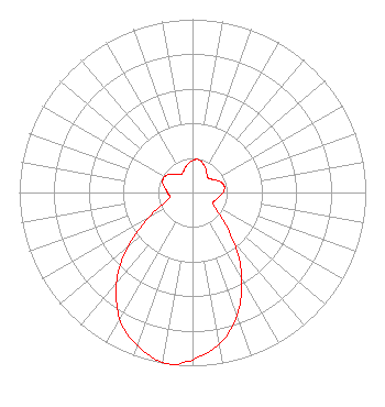 | ||||||||||||||||||
| Azimuth | Ratio | Azimuth | Ratio | Azimuth | Ratio | Azimuth | Ratio | ||||||||||||
| 8 | 0.193 | 18 | 0.182 | 28 | 0.160 | 38 | 0.135 | ||||||||||||
| 48 | 0.123 | 58 | 0.140 | 68 | 0.171 | 78 | 0.187 | ||||||||||||
| 88 | 0.181 | 98 | 0.157 | 108 | 0.142 | 118 | 0.134 | ||||||||||||
| 128 | 0.190 | 138 | 0.329 | 148 | 0.528 | 158 | 0.718 | ||||||||||||
| 168 | 0.866 | 178 | 0.952 | 188 | 1.000 | 198 | 0.952 | ||||||||||||
| 208 | 0.866 | 218 | 0.718 | 228 | 0.528 | 238 | 0.329 | ||||||||||||
| 248 | 0.190 | 258 | 0.134 | 268 | 0.142 | 278 | 0.157 | ||||||||||||
| 288 | 0.181 | 298 | 0.187 | 308 | 0.171 | 318 | 0.140 | ||||||||||||
| 328 | 0.123 | 338 | 0.135 | 348 | 0.160 | 358 | 0.182 | ||||||||||||
Structure Registration Number 1014966 Structure Type: TOWER Registered To: Coastal Towers, Inc. Structure Address: Off Woody Rd 6 Km N Oildale, CA County Name: Kern County ASR Issued: 01/10/2013 Date Built: 06/01/1989 Site Elevation: 268 m (879 ft.) Structure Height: 67 m (220 ft.) Height Overall: 67 m (220 ft.) Overall Height AMSL: 335 m (1099 ft.) FAA Determination: 02/06/1991 FAA Study #: 89-AWP-547-OE FAA Circular #: 70/7460-1G Paint & Light FAA Chapters: 3, 4, 5, 9 35-28-21.0 N 119-01-43.0 W (NAD 83) 35-28-21.2 N 119-01-39.6 W (Converted to NAD 27) |
Attn: L. Rogers Brandon P.o. Box 2700 Bakersfield, CA 93303 Phone: 661-328-0118 Corporation | Date: 10/12/2017 Application Certifier AGM CALIFORNIA, INC. Attn: L. Rogers Brandon P.o. Box 2700 Bakersfield, CA 93303 Applicant DARRYL K. DELAWDER Delawder Communications P.o. Box 1095 Ashburn, VA 20146 CONSULTING ENGINEER JOHN NEELY, ESQ Miller And Neely Pc Suite 203 3750 University Blvd., West Kensington, MD 20895 | |||||||||||||||||