
FCCInfo.com
A Service of Cavell, Mertz & Associates, Inc.
(855) FCC-INFO
|
|
K233DB from 01/06/2014 |
|
|
||||||||||||||||
|
|
K233DB Channel: 233D 94.5 MHz San Antonio, Texas Service: FX - A translator or application for a translator. Facility ID: 142569 Fac. Service: FX Programming Delivery Method: Unspecified Status: License Application Accepted: 11/13/2014 Application Granted: 12/02/2014 File Number: BLFT-20141113AGI License Expires: 00/00/0000 Prefix Type: This is a license for a translator Application Type: License To Cover FCC Website Links: LMS Facility Details This Application CDBS Application Other K233DB Applications Other K233DB Applications in CDBS Including Superseded Applications Mailing Address Correspondence for K233DB Correspondence related to application BLFT-20141113AGI Service Contour - Open Street Map or USGS Map (60 dBu) Service Contour - KML / Google Earth (60 dBu) Class: D, A Noncommercial educational operating with no more than 10W Site Location: 29-26-29.8 N 98-30-23.1 W (NAD 83) Site Location: 29-26-29.0 N 98-30-22.0 W (Converted to NAD 27) Effective Radiated Power: 0.25 kW Transmitter Output Power: 0.69 kW Antenna Center HAAT: 0 m Antenna Center AMSL: 344 m (1129 ft.) Antenna Center HAG: 137 m (449 ft.) Site Elevation: 207 m. (679 ft.) Height Overall*: 152 m (499 ft.) (* As Filed In This Application, may differ from ASR Data, Below.) Directional Antenna Antenna Make/Model: None Antenna ID: 119867 Polarization:
| ||||||||||||||||||
| Antenna Data for Antenna Id: 119867 K233DB FX File: BLFT-20141113AGI None - Service: FX Pattern and Field Values Include a 336° Clockwise Rotation | 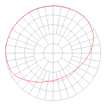 | ||||||||||||||||||
| Azimuth | Ratio | Azimuth | Ratio | Azimuth | Ratio | Azimuth | Ratio | ||||||||||||
| 6 | 0.988 | 16 | 0.988 | 26 | 0.992 | 36 | 1.000 | ||||||||||||
| 46 | 0.991 | 56 | 0.963 | 66 | 0.923 | 76 | 0.862 | ||||||||||||
| 86 | 0.797 | 96 | 0.731 | 106 | 0.676 | 116 | 0.628 | ||||||||||||
| 126 | 0.594 | 136 | 0.571 | 146 | 0.558 | 156 | 0.553 | ||||||||||||
| 166 | 0.558 | 176 | 0.571 | 186 | 0.594 | 196 | 0.628 | ||||||||||||
| 206 | 0.682 | 216 | 0.738 | 226 | 0.815 | 236 | 0.897 | ||||||||||||
| 246 | 0.953 | 256 | 0.973 | 266 | 0.983 | 276 | 1.000 | ||||||||||||
| 286 | 0.992 | 296 | 0.988 | 306 | 0.988 | 316 | 0.983 | ||||||||||||
| 326 | 0.983 | 336 | 0.983 | 346 | 0.983 | 356 | 0.983 | ||||||||||||
Structure Registration Number 1214327 Structure Type: GTOWER Registered To: American Towers LLC Structure Address: 1010 W. Laurel St. (atc Site # 282679) San Antonio, TX County Name: Bexar County ASR Issued: 05/24/2016 Date Built: 07/12/2001 Site Elevation: 207.2 m (680 ft.) Structure Height: 152 m (499 ft.) Height Overall: 152 m (499 ft.) Overall Height AMSL: 359.2 m (1178 ft.) FAA Determination: 03/16/2016 FAA Study #: 2016-ASW-2905-OE FAA Circular #: 70/7460-1L Paint & Light FAA Chapters: 4, 8, 12 PRIOR STUDY 2000-ASW-1251-OE 29-26-29.9 N 98-30-22.8 W (NAD 83) 29-26-29.1 N 98-30-21.7 W (Converted to NAD 27) |
1211 Sw 5th Avenue Suite 750 Portland, OR 97204 Phone: 503-517-6200 Limited Liability Company | Date: 11/13/2014 Application Certifier ALPHA MEDIA LICENSEE LLC 1211 Sw 5th Avenue Suite 750 Portland, OR 97204 Applicant MICHAEL EVERHART Alpha Media Licensee Llc 1211 Sw Fifth Avenue #750 Portland, OR 97204 DIRECTOR OF ENGINEERING MARNIE K. SARVER Wiley Rein Llp 1776 K Street, Nw Washington, DC 20006 | |||||||||||||||||