
FCCInfo.com
A Service of Cavell, Mertz & Associates, Inc.
(855) FCC-INFO
|
|
K241CI from 04/24/2013 |
|
|
||||||||||||||||
|
|
K241CI Channel: 241D 96.1 MHz Bakersfield, California Service: FX - A translator or application for a translator. Facility ID: 139845 Fac. Service: FX Programming Delivery Method: Unspecified Status: License Application Accepted: 12/01/2014 Application Granted: 12/10/2014 File Number: BLFT-20141201AIH License Expires: 00/00/0000 Prefix Type: This is a license for a translator Application Type: License To Cover FCC Website Links: LMS Facility Details This Application CDBS Application Other K241CI Applications Other K241CI Applications in CDBS Including Superseded Applications Mailing Address Correspondence for K241CI Correspondence related to application BLFT-20141201AIH Service Contour - Open Street Map or USGS Map (60 dBu) Service Contour - KML / Google Earth (60 dBu) Class: D, A Noncommercial educational operating with no more than 10W Site Location: 35-28-20.8 N 119-01-43.4 W (NAD 83) Site Location: 35-28-21.0 N 119-01-40.0 W (Converted to NAD 27) Effective Radiated Power: 0.25 kW Transmitter Output Power: 0.294 kW Antenna Center HAAT: 0 m Antenna Center AMSL: 320 m (1050 ft.) Antenna Center HAG: 52 m (171 ft.) Site Elevation: 268 m. (879 ft.) Height Overall*: 67 m (220 ft.) (* As Filed In This Application, may differ from ASR Data, Below.) Directional Antenna Antenna Make/Model: None Antenna ID: 119927 Polarization:
| ||||||||||||||||||
| Antenna Data for Antenna Id: 119927 K241CI FX File: BLFT-20141201AIH None - Service: FX Pattern and Field Values Include a 292° Clockwise Rotation | 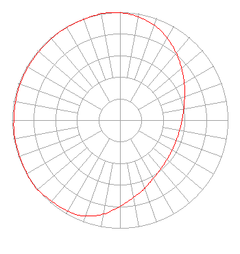 | ||||||||||||||||||
| Azimuth | Ratio | Azimuth | Ratio | Azimuth | Ratio | Azimuth | Ratio | ||||||||||||
| 2 | 0.991 | 12 | 0.963 | 22 | 0.923 | 32 | 0.862 | ||||||||||||
| 42 | 0.797 | 52 | 0.731 | 62 | 0.676 | 72 | 0.628 | ||||||||||||
| 82 | 0.594 | 92 | 0.571 | 102 | 0.558 | 112 | 0.553 | ||||||||||||
| 122 | 0.558 | 132 | 0.571 | 142 | 0.594 | 152 | 0.628 | ||||||||||||
| 162 | 0.682 | 172 | 0.738 | 182 | 0.815 | 192 | 0.897 | ||||||||||||
| 202 | 0.953 | 212 | 0.973 | 222 | 0.983 | 232 | 1.000 | ||||||||||||
| 242 | 0.992 | 252 | 0.988 | 262 | 0.988 | 272 | 0.983 | ||||||||||||
| 282 | 0.983 | 292 | 0.983 | 302 | 0.983 | 312 | 0.983 | ||||||||||||
| 322 | 0.988 | 332 | 0.988 | 342 | 0.992 | 352 | 1.000 | ||||||||||||
Structure Registration Number 1014966 Structure Type: TOWER Registered To: Coastal Towers, Inc. Structure Address: Off Woody Rd 6 Km N Oildale, CA County Name: Kern County ASR Issued: 01/10/2013 Date Built: 06/01/1989 Site Elevation: 268 m (879 ft.) Structure Height: 67 m (220 ft.) Height Overall: 67 m (220 ft.) Overall Height AMSL: 335 m (1099 ft.) FAA Determination: 02/06/1991 FAA Study #: 89-AWP-547-OE FAA Circular #: 70/7460-1G Paint & Light FAA Chapters: 3, 4, 5, 9 35-28-21.0 N 119-01-43.0 W (NAD 83) 35-28-21.2 N 119-01-39.6 W (Converted to NAD 27) |
Attn: L. Rogers Brandon P.o. Box 2700 Bakersfield, CA 93303 Phone: 661-328-0118 Corporation | Date: 12/01/2014 Application Certifier AGM CALIFORNIA, INC. Attn: L. Rogers Brandon P.o. Box 2700 Bakersfield, CA 93303 Applicant RUSTY BURCHFIELD Po Box 2700 Bakersfield, CA 93303 DIRECTOR OF ENGINEERING LEWIS J. PAPER, ESQ. Pillsbury Winthrop Shaw Pittman Llp 2300 N Street, Nw Washington, DC 20037 | |||||||||||||||||