
FCCInfo.com
A Service of Cavell, Mertz & Associates, Inc.
(855) FCC-INFO
|
|
|
|  |
|
|||||||||||||||
|
|
WSUM Channel: 219A 91.7 MHz Madison, Wisconsin Service: FM - A full-service FM station or application. Facility ID: 79040 Fac. Service: FM Status: License Application Accepted: 05/17/2017 Application Granted: 07/06/2017 File Number: BMLED-20170517ABS License Expires: 00/00/0000 Prefix Type: This is a modification of license for a noncommercial educational FM station Application Type: Minor Modification FCC Website Links: LMS Facility Details This Application CDBS Application Other WSUM Applications Other WSUM Applications in CDBS Including Superseded Applications Mailing Address Correspondence for WSUM Correspondence related to application BMLED-20170517ABS Service Contour - Open Street Map or USGS Map (60 dBu) Service Contour - KML / Google Earth (60 dBu) Public Inspection Files Facility Type: NON-COMMERCIAL EDUC. FM Class: A, A Zone I; I-A; or II station; with 0.1kW-6kW ERP and a class contour distance <=28km Site Location: 42-54-16.0 N 89-33-21.4 W (NAD 83) Site Location: 42-54-16.0 N 89-33-21.0 W (Converted to NAD 27) Effective Radiated Power: 5.5 kW Transmitter Output Power: 3.346 kW Antenna Center HAAT: 103 m (338 ft.) Antenna Center AMSL: 403.5 m (1324 ft.) Antenna Center HAG: 117 m (384 ft.) Site Elevation: 286.5 m. (940 ft.) Height Overall*: 122.8 m (403 ft.) (* As Filed In This Application, may differ from ASR Data, Below.) Directional Antenna Antenna Make/Model: None ERI 1091-1CP-DA, 1 section Antenna ID: 58937 Polarization: | ||||||||||||||||||
| Antenna Data for Antenna Id: 58937 WSUM FM File: BMLED-20170517ABS None - ERI 1091-1CP-DA, 1 section Service: FM | 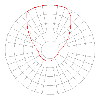 | ||||||||||||||||||
| Azimuth | Ratio | Azimuth | Ratio | Azimuth | Ratio | Azimuth | Ratio | ||||||||||||
| 0 | 1.000 | 10 | 1.000 | 20 | 1.000 | 30 | 0.897 | ||||||||||||
| 40 | 0.713 | 50 | 0.566 | 60 | 0.450 | 70 | 0.357 | ||||||||||||
| 80 | 0.288 | 90 | 0.235 | 100 | 0.206 | 110 | 0.200 | ||||||||||||
| 120 | 0.200 | 130 | 0.200 | 140 | 0.200 | 150 | 0.207 | ||||||||||||
| 160 | 0.224 | 170 | 0.243 | 180 | 0.254 | 190 | 0.262 | ||||||||||||
| 200 | 0.262 | 210 | 0.262 | 220 | 0.262 | 230 | 0.262 | ||||||||||||
| 240 | 0.262 | 250 | 0.262 | 260 | 0.262 | 270 | 0.290 | ||||||||||||
| 280 | 0.330 | 290 | 0.396 | 300 | 0.498 | 310 | 0.628 | ||||||||||||
| 320 | 0.790 | 330 | 0.995 | 340 | 1.000 | 350 | 1.000 | ||||||||||||
Structure Registration Number 1045235 Structure Type: GTOWER Registered To: UNIVERSITY OF WISCONSIN BOARD OF REGENTS DBA WSUM RADIO Structure Address: 0.3 Km Se Of Int Of Observatory Rd And County Trunk A Montrose, WI County Name: Dane County ASR Issued: 09/12/2018 Date Built: 11/19/2001 Site Elevation: 286.2 m (939 ft.) Structure Height: 121.9 m (400 ft.) Height Overall: 122.8 m (403 ft.) Overall Height AMSL: 409 m (1342 ft.) FAA Determination: 07/08/1998 FAA Study #: 98-AGL-1880-OE FAA Circular #: 70/7460-1J Paint & Light FAA Chapters: 3, 4, 5, 13 PRIOR FAA 95-AGL-2722-OE 42-54-16.3 N 89-33-21.3 W (NAD 83) 42-54-16.3 N 89-33-20.9 W (Converted to NAD 27) |
1860 Van Hise Hall 1220 Linden Drive Madison, WI 53706 Phone: 608-262-2326 Government Entity | Date: 05/17/2017 Application Certifier BOARD OF REGENTS OF THE UNIVERSITY OF WISCONSIN SYSTEM 1860 Van Hise Hall 1220 Linden Dr. Madison, WI 53706 Applicant DOUG VERNIER 1600 Picturesque Dr. Cedar Falls, IA 50677 ENGINEERING CONSULTANT BARRY S. PERSH Gray Miller Persh Llp | |||||||||||||||||
| |||||||||||||||||||