
FCCInfo.com
A Service of Cavell, Mertz & Associates, Inc.
(855) FCC-INFO
|
|
W287CW from 04/26/2004 |
|
|
||||||||||||||||
|
|
W287CW Channel: 287D 105.3 MHz Methuen, Massachusetts Service: FX - A translator or application for a translator. Facility ID: 139956 Fac. Service: FX Programming Delivery Method: Unspecified Status: License Application Accepted: 12/21/2017 Application Granted: 01/31/2018 File Number: BLFT-20171221AAP License Expires: 00/00/0000 Prefix Type: This is a license for a translator Application Type: License To Cover FCC Website Links: LMS Facility Details This Application CDBS Application Other W287CW Applications Other W287CW Applications in CDBS Including Superseded Applications Mailing Address Correspondence for W287CW Correspondence related to application BLFT-20171221AAP Service Contour - Open Street Map or USGS Map (60 dBu) Service Contour - KML / Google Earth (60 dBu) Class: D, A Noncommercial educational operating with no more than 10W Site Location: 42-25-52.3 N 71-05-17.2 W (NAD 83) Site Location: 42-25-52.0 N 71-05-19.0 W (Converted to NAD 27) Effective Radiated Power: 0.25 kW Transmitter Output Power: 0.167 kW Antenna Center HAAT: 106 m (348 ft.) Antenna Center AMSL: 141 m (463 ft.) Antenna Center HAG: 84 m (276 ft.) Site Elevation: 57 m. (187 ft.) Height Overall*: 109 m (358 ft.) (* As Filed In This Application, may differ from ASR Data, Below.) Directional Antenna Antenna Make/Model: None Antenna ID: 129654 Polarization:
| ||||||||||||||||||
| Antenna Data for Antenna Id: 129654 W287CW FX File: BLFT-20171221AAP None - Service: FX | 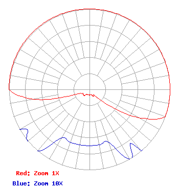 | ||||||||||||||||||
| Azimuth | Ratio | Azimuth | Ratio | Azimuth | Ratio | Azimuth | Ratio | ||||||||||||
| 0 | 1.000 | 10 | 1.000 | 20 | 1.000 | 30 | 1.000 | ||||||||||||
| 40 | 1.000 | 50 | 1.000 | 60 | 1.000 | 70 | 1.000 | ||||||||||||
| 80 | 1.000 | 90 | 1.000 | 100 | 1.000 | 110 | 1.000 | ||||||||||||
| 120 | 0.700 | 130 | 0.300 | 140 | 0.100 | 150 | 0.100 | ||||||||||||
| 160 | 0.070 | 170 | 0.070 | 180 | 0.070 | 190 | 0.070 | ||||||||||||
| 200 | 0.070 | 210 | 0.070 | 220 | 0.100 | 230 | 0.100 | ||||||||||||
| 240 | 0.100 | 250 | 0.200 | 260 | 0.700 | 270 | 1.000 | ||||||||||||
| 280 | 1.000 | 290 | 1.000 | 300 | 1.000 | 310 | 1.000 | ||||||||||||
| 320 | 1.000 | 330 | 1.000 | 340 | 1.000 | 350 | 1.000 | ||||||||||||
Structure Registration Number 1003922 Structure Type: LTOWER Registered To: Industrial Tower and Wireless, LLC Structure Address: 146 Murray St Medford, MA County Name: Middlesex County ASR Issued: 03/03/2023 Date Built: 01/01/1985 Site Elevation: 57.3 m (188 ft.) Structure Height: 105 m (344 ft.) Height Overall: 108.8 m (357 ft.) Overall Height AMSL: 166.1 m (545 ft.) FAA Determination: 02/27/2023 FAA Study #: 2022-ANE-2141-OE FAA Circular #: 70/7460-1K Paint & Light FAA Chapters: 4, 8, 12 PRIOR STUDY 2004-ANE-555-OE 42-25-52.0 N 71-05-17.0 W (NAD 83) 42-25-51.7 N 71-05-18.8 W (Converted to NAD 27) |
462 Merrimack Street Methuen, MA 01844 Phone: 978-686-9966 | Date: 12/21/2017 Application Certifier COSTA-EAGLE RADIO VENTURES LIMITED PARTNERSHIP 462 Merrimack Street Methuen, MA 01844 Applicant JUSTIN ASHER Asher Broadcast Consulting, Llc 579 Babcock Road Bronson, MI 49028-9347 TECHNICAL CONSULTANT AARON P. SHAINIS Shainis & Peltzman, Chartered 1850 M Street, Nw Suite 240 Washington, DC 20036 | |||||||||||||||||