
FCCInfo.com
A Service of Cavell, Mertz & Associates, Inc.
(855) FCC-INFO
|
|
WNRW from 12/26/2000 WNRW from 01/06/2000 WNRW from 09/17/1999 WNRW from 10/02/1996 WNRW from 09/27/1996 WNRW from 09/30/1993 WNRW from 04/02/1979 |
|
|
|||||||||||||||||||
|
|
WNRW Channel: 255C2 98.9 MHz Prospect, Kentucky Service: FM - A full-service FM station or application. Facility ID: 60706 Fac. Service: FM Analog & Digital Status: License 73.215 Station Application Accepted: 05/07/2010 Application Granted: 10/05/2010 File Number: BLH-20100507ACN License Expires: 00/00/0000 Prefix Type: This is a license for a commercial FM station Application Type: License To Cover FCC Website Links: LMS Facility Details This Application CDBS Application Other WNRW Applications Other WNRW Applications in CDBS Including Superseded Applications Mailing Address Correspondence for WNRW Correspondence related to application BLH-20100507ACN Service Contour - Open Street Map or USGS Map (60 dBu) Service Contour - KML / Google Earth (60 dBu) Public Inspection Files History Cards for WNRW Facility Type: FM STATION Class: C2, A Zone II station; with 25kW-50kW ERP and a class contour distance 39km-52km Site Location: 38-11-31.2 N 85-31-10.8 W (NAD 83) Site Location: 38-11-31.0 N 85-31-11.0 W (Converted to NAD 27) Effective Radiated Power: 43 kW Transmitter Output Power: 20.1 kW Antenna Center HAAT: 157 m (515 ft.) Antenna Center AMSL: 353 m (1158 ft.) Antenna Center HAG: 137 m (449 ft.) Site Elevation: 216.4 m. (710 ft.) Height Overall*: 146.8 m (482 ft.) (* As Filed In This Application, may differ from ASR Data, Below.) Directional Antenna Antenna Make/Model: Electronics Research Inc. MP-4C-DA, Four Sections Antenna ID: 93509 Polarization: | |||||||||||||||||||||
| Antenna Data for Antenna Id: 93509 WNRW FM File: BLH-20100507ACN Electronics Research Inc. - MP-4C-DA, Four Sections Service: FM | 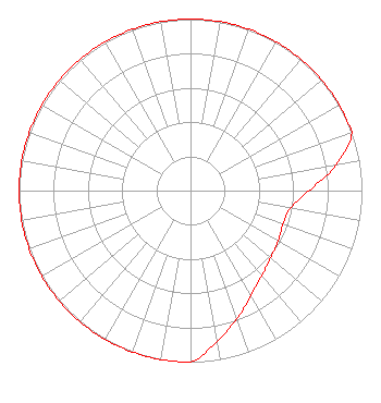 | |||||||||||||||||||||
| Azimuth | Ratio | Azimuth | Ratio | Azimuth | Ratio | Azimuth | Ratio | |||||||||||||||
| 0 | 1.000 | 10 | 1.000 | 20 | 1.000 | 30 | 1.000 | |||||||||||||||
| 40 | 1.000 | 50 | 1.000 | 60 | 1.000 | 70 | 1.000 | |||||||||||||||
| 80 | 0.863 | 90 | 0.691 | 100 | 0.592 | 110 | 0.574 | |||||||||||||||
| 120 | 0.590 | 130 | 0.609 | 140 | 0.648 | 150 | 0.707 | |||||||||||||||
| 160 | 0.794 | 170 | 0.891 | 180 | 1.000 | 190 | 1.000 | |||||||||||||||
| 200 | 1.000 | 210 | 1.000 | 220 | 1.000 | 230 | 1.000 | |||||||||||||||
| 240 | 1.000 | 250 | 1.000 | 260 | 1.000 | 270 | 1.000 | |||||||||||||||
| 280 | 1.000 | 290 | 1.000 | 300 | 1.000 | 310 | 1.000 | |||||||||||||||
| 320 | 1.000 | 330 | 1.000 | 340 | 1.000 | 350 | 1.000 | |||||||||||||||
Structure Registration Number 1045578 Structure Type: 4TA4 Registered To: iHeartMedia Entertainment, Inc. Structure Address: Twr 4 - 2.2 Mi E Jeffersontown, KY County Name: Jefferson County ASR Issued: 08/29/2017 Date Built: 02/10/1971 Site Elevation: 216.4 m (710 ft.) Structure Height: 145.8 m (478 ft.) Height Overall: 146.8 m (482 ft.) Overall Height AMSL: 363.2 m (1192 ft.) FAA Determination: 06/23/1998 FAA Study #: 98-ASO-3599-OE FAA Circular #: 70/7460-1J Paint & Light FAA Chapters: 3, 4, 5, 13 REF. 71-ASO-0210-OE. 38-11-31.0 N 85-31-11.0 W (NAD 83) 38-11-30.8 N 85-31-11.2 W (Converted to NAD 27) |
7136 S. Yale Avenue Suite 501 Tulsa, OK 74136 Phone: 918-664-4581 | Date: 05/07/2010 Application Certifier CC LICENSES, LLC 2625 S. Memorial Drive Tulsa, OK 74129 Applicant TROY G. LANGHAM 2625 S. Memorial Drive Suite A Tulsa, OK 74129-2623 FCC ENGINEERING SUPERVISOR MARISSA G. REPP Hogan & Hartson, L.l.p. | ||||||||||||||||||||
| ||||||||||||||||||||||