
FCCInfo.com
A Service of Cavell, Mertz & Associates, Inc.
(855) FCC-INFO
|
|
|
|
|
||||||||||||||||
|
|
W225CW Channel: 225D 92.9 MHz Parkersburg, West Virginia Service: FX - A translator or application for a translator. Facility ID: 200695 Fac. Service: FX Programming Delivery Method: Unspecified Status: License Application Accepted: 05/04/2018 Application Granted: 05/14/2018 File Number: BLFT-20180504AAR License Expires: 00/00/0000 Prefix Type: This is a license for a translator Application Type: License To Cover FCC Website Links: LMS Facility Details This Application CDBS Application Other W225CW Applications Other W225CW Applications in CDBS Including Superseded Applications Mailing Address Correspondence for W225CW Correspondence related to application BLFT-20180504AAR Service Contour - Open Street Map or USGS Map (60 dBu) Service Contour - KML / Google Earth (60 dBu) Class: D, A Noncommercial educational operating with no more than 10W Site Location: 39-20-17.7 N 81-29-56.0 W (NAD 83) Site Location: 39-20-17.4 N 81-29-56.6 W (Converted to NAD 27) Effective Radiated Power: 0.25 kW Transmitter Output Power: 0.71 kW Antenna Center HAAT: 0 m Antenna Center AMSL: 343 m (1125 ft.) Antenna Center HAG: 38 m (125 ft.) Site Elevation: 305 m. (1001 ft.) Height Overall*: 59 m (194 ft.) (* As Filed In This Application, may differ from ASR Data, Below.) Directional Antenna Antenna Make/Model: None Antenna ID: 130083 Polarization:
| ||||||||||||||||||
| Antenna Data for Antenna Id: 130083 W225CW FX File: BLFT-20180504AAR None - Service: FX | 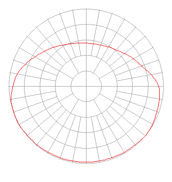 | ||||||||||||||||||
| Azimuth | Ratio | Azimuth | Ratio | Azimuth | Ratio | Azimuth | Ratio | ||||||||||||
| 0 | 0.554 | 10 | 0.554 | 20 | 0.563 | 30 | 0.583 | ||||||||||||
| 40 | 0.610 | 50 | 0.653 | 60 | 0.706 | 70 | 0.764 | ||||||||||||
| 80 | 0.853 | 90 | 0.939 | 100 | 0.963 | 110 | 0.973 | ||||||||||||
| 120 | 0.993 | 130 | 1.000 | 140 | 0.988 | 150 | 0.988 | ||||||||||||
| 160 | 0.983 | 170 | 0.983 | 180 | 0.983 | 190 | 0.983 | ||||||||||||
| 200 | 0.983 | 210 | 0.983 | 220 | 0.988 | 230 | 0.988 | ||||||||||||
| 240 | 1.000 | 250 | 0.993 | 260 | 0.983 | 270 | 0.943 | ||||||||||||
| 280 | 0.900 | 290 | 0.830 | 300 | 0.756 | 310 | 0.699 | ||||||||||||
| 320 | 0.653 | 330 | 0.610 | 340 | 0.580 | 350 | 0.563 | ||||||||||||
Structure Registration Number 1285964 Structure Type: GTOWER Registered To: Mid Ohio Valley Radio Corp. Structure Address: 259 Pleasant Valley School Road Vienna, WV County Name: Wood County ASR Issued: 03/12/2018 Date Built: 07/25/2013 Site Elevation: 304.8 m (1000 ft.) Structure Height: 59.4 m (195 ft.) Height Overall: 59.4 m (195 ft.) Overall Height AMSL: 364.2 m (1195 ft.) FAA Determination: 06/26/2012 FAA Study #: 2012-AEA-2634-OE Paint & Light FAA Chapters: NONE Removed expiration date from determination. Scenario 1./jjs/case#635066 39-20-17.6 N 81-29-56.0 W (NAD 83) 39-20-17.3 N 81-29-56.6 W (Converted to NAD 27) |
925 Lancaster St. Marietta, OH 45750 Phone: 740-373-1490 | Date: 05/04/2018 Application Certifier JAWCO, INC 925 Lancaster Street Marietta, OH 45750 Applicant JOHN WHARFF Jawco, Inc. 925 Lancaster Street Marietta, OH 45750 MARK A. HINER P.o. Box 325 Etna, OH 43018-0325 TECHNICAL CONSULTANT | |||||||||||||||||