
FCCInfo.com
A Service of Cavell, Mertz & Associates, Inc.
(855) FCC-INFO
|
|
KJAK from 03/25/2016 |
|
|
||||||||||||||||
|
|
KJAK Channel: 277A 103.3 MHz Pearsall, Texas Service: FM - A full-service FM station or application. Facility ID: 198762 Fac. Service: FM Status: Construction Permit 73.215 Station Application Accepted: 10/13/2015 Application Granted: 11/10/2015 File Number: BNPH-20151013AIL KJAK CP Expires: 11/10/2018 Prefix Type: This is BNPH Application Type: Construction Permit FCC Website Links: LMS Facility Details This Application CDBS Application Other KJAK Applications Other KJAK Applications in CDBS Including Superseded Applications Mailing Address Correspondence for KJAK Correspondence related to application BNPH-20151013AIL Service Contour - Open Street Map or USGS Map (60 dBu) Service Contour - KML / Google Earth (60 dBu) Public Inspection Files Facility Type: FM STATION Class: A, A Zone I; I-A; or II station; with 0.1kW-6kW ERP and a class contour distance <=28km Site Location: 28-56-34.9 N 99-16-48.1 W (NAD 83) Site Location: 28-56-34.0 N 99-16-47.0 W (Converted to NAD 27) Effective Radiated Power: 6 kW Antenna Center HAAT: 100 m (328 ft.) Antenna Center AMSL: 289 m (948 ft.) Antenna Center HAG: 82 m (269 ft.) Calculated Site Elevation: 207 m. (679 ft.) Height Overall*: 263 m (863 ft.) (* As Filed In This Application, may differ from ASR Data, Below.) Directional Antenna Antenna Make/Model: None Antenna ID: 122356 Polarization: | ||||||||||||||||||
| Antenna Data for Antenna Id: 122356 KJAK FM File: BNPH-20151013AIL None - Service: FM | 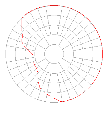 | ||||||||||||||||||
| Azimuth | Ratio | Azimuth | Ratio | Azimuth | Ratio | Azimuth | Ratio | ||||||||||||
| 0 | 1.000 | 10 | 1.000 | 20 | 1.000 | 30 | 1.000 | ||||||||||||
| 40 | 1.000 | 50 | 1.000 | 60 | 1.000 | 70 | 1.000 | ||||||||||||
| 80 | 1.000 | 90 | 1.000 | 100 | 1.000 | 110 | 1.000 | ||||||||||||
| 120 | 1.000 | 130 | 1.000 | 140 | 1.000 | 150 | 1.000 | ||||||||||||
| 160 | 1.000 | 170 | 1.000 | 180 | 0.910 | 190 | 0.840 | ||||||||||||
| 200 | 0.780 | 210 | 0.653 | 220 | 0.520 | 230 | 0.470 | ||||||||||||
| 240 | 0.460 | 250 | 0.460 | 260 | 0.440 | 270 | 0.450 | ||||||||||||
| 280 | 0.562 | 290 | 0.700 | 300 | 0.750 | 310 | 0.870 | ||||||||||||
| 320 | 1.000 | 330 | 1.000 | 340 | 1.000 | 350 | 1.000 | ||||||||||||
Structure Registration Number 1224979 Structure Type: TOWER Registered To: Global Tower, LLC. through American Towers, LLC Structure Address: 8.75 Km South Of City Of Frio, Texas. Frio, TX County Name: Frio County ASR Issued: 09/02/2014 Date Built: 01/10/2003 Site Elevation: 207 m (679 ft.) Structure Height: 261 m (856 ft.) Height Overall: 263 m (863 ft.) Overall Height AMSL: 470 m (1542 ft.) FAA Determination: 03/15/2001 FAA Study #: 00-ASW-5646-OE FAA Circular #: 70/7460-1K Paint & Light FAA Chapters: 3, 4, 5, 12 Removed expiration and final dates from determination. Scenario 2./jjs/case#635066 28-56-34.8 N 99-16-48.1 W (NAD 83) 28-56-33.9 N 99-16-47.0 W (Converted to NAD 27) |
1211 Sw 5th Avenue Suite 750 Portland, OR 97204 Phone: 503-517-6200 Limited Liability Company | Date: 10/13/2015 Application Certifier ALPHA MEDIA LICENSEE LLC 1211 Sw 5th Avenue Suite 750 Portland, OR 97204 Applicant LARAMIE GUEST 1332 Wynbrook Trace Mount Pleasant, SC 29466 TECHNICAL CONSULTANT MARNIE K. SARVER Wiley Rein Llp 1776 K Street, N.w. Washington, DC 20006 | |||||||||||||||||