
FCCInfo.com
A Service of Cavell, Mertz & Associates, Inc.
(855) FCC-INFO
|
|
WSSR from 07/24/1979 |
|  |
|
|||||||||||||||
|
|
WSSR Channel: 244A 96.7 MHz Joliet, Illinois Service: FM - A full-service FM station or application. Facility ID: 62240 Fac. Service: FM Analog & Digital Status: License (Licensed And Reduced Power) 73.215 Station Application Accepted: 04/02/2008 Application Granted: 04/09/2008 File Number: BLH-20080402AAF License Expires: 00/00/0000 Prefix Type: This is a license for a commercial FM station Application Type: License To Cover FCC Website Links: LMS Facility Details This Application CDBS Application Other WSSR Applications Other WSSR Applications in CDBS Including Superseded Applications Mailing Address Correspondence for WSSR Correspondence related to application BLH-20080402AAF Service Contour - Open Street Map or USGS Map (60 dBu) Service Contour - KML / Google Earth (60 dBu) Public Inspection Files History Cards for WSSR Facility Type: FM STATION Class: A, A Zone I; I-A; or II station; with 0.1kW-6kW ERP and a class contour distance <=28km Site Location: 41-36-01.1 N 87-58-44.2 W (NAD 83) Site Location: 41-36-01.0 N 87-58-44.0 W (Converted to NAD 27) Effective Radiated Power: 3.1 kW Transmitter Output Power: 1.59 kW Antenna Center HAAT: 142 m (466 ft.) Antenna Center AMSL: 349 m (1145 ft.) Antenna Center HAG: 107 m (351 ft.) Calculated Site Elevation: 242 m. (794 ft.) Height Overall*: 122 m (400 ft.) (* As Filed In This Application, may differ from ASR Data, Below.) Directional Antenna Antenna Make/Model: DE DCRM4E5RD Antenna ID: 83939 Polarization: | ||||||||||||||||||
| Antenna Data for Antenna Id: 83939 WSSR FM File: BLH-20080402AAF DE - DCRM4E5RD Service: FM | 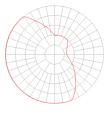 | ||||||||||||||||||
| Azimuth | Ratio | Azimuth | Ratio | Azimuth | Ratio | Azimuth | Ratio | ||||||||||||
| 0 | 0.398 | 10 | 0.398 | 20 | 0.398 | 30 | 0.398 | ||||||||||||
| 40 | 0.398 | 50 | 0.355 | 60 | 0.299 | 70 | 0.266 | ||||||||||||
| 80 | 0.251 | 90 | 0.251 | 100 | 0.282 | 110 | 0.335 | ||||||||||||
| 120 | 0.422 | 130 | 0.531 | 140 | 0.668 | 150 | 0.841 | ||||||||||||
| 160 | 1.000 | 170 | 1.000 | 180 | 1.000 | 190 | 1.000 | ||||||||||||
| 200 | 1.000 | 210 | 1.000 | 220 | 1.000 | 230 | 1.000 | ||||||||||||
| 240 | 1.000 | 250 | 1.000 | 260 | 1.000 | 270 | 1.000 | ||||||||||||
| 280 | 1.000 | 290 | 1.000 | 300 | 1.000 | 310 | 1.000 | ||||||||||||
| 320 | 1.000 | 330 | 0.794 | 340 | 0.631 | 350 | 0.501 | ||||||||||||
Structure Registration Number 1023012 [ASR Heights Differ from WSSR Application] Structure Type: LTOWER Registered To: MidAmerica Towers, Inc Structure Address: 1/8 Mi N Of Il Rt 7 & Cedar Rd Lockport, IL County Name: Will County ASR Issued: 12/05/2016 Date Built: 01/01/1983 Site Elevation: 245 m (804 ft.) Structure Height: 100.5 m (330 ft.) Height Overall: 108.5 m (356 ft.) Overall Height AMSL: 353.5 m (1160 ft.) FAA Determination: 03/22/2016 FAA Study #: 2015-AGL-15465-OE FAA Circular #: 70/7460-1L Paint & Light FAA Chapters: 4, 8, 12 PRIOR STUDY 2008-AGL-3861-OE 41-36-02.5 N 87-58-43.9 W (NAD 83) 41-36-02.4 N 87-58-43.7 W (Converted to NAD 27) |
1211 Sw 5th Avenue Suite 750 Portland, OR 97204 Phone: 503-517-6200 Limited Liability Company | Date: 04/02/2008 Application Certifier NM LICENSING LLC 6312 South Fiddlers Green Cir. Suite 205-e Greenwood Village, CO 80111 Applicant WES DAVIS 1361 Colony Drive New Bern, NC 28562 VP ENGINEERING JOSEPH A. BELISLE Leibowitz & Associates | |||||||||||||||||
| |||||||||||||||||||