
FCCInfo.com
A Service of Cavell, Mertz & Associates, Inc.
(855) FCC-INFO
|
|
KLKL from 11/07/1997 KLKL from 06/12/1979 |
|  |
|
|||||||||||||||
|
|
KLKL Channel: 239C2 95.7 MHz Minden, Louisiana Service: FM - A full-service FM station or application. Facility ID: 13802 Fac. Service: FM Status: License 73.215 Station Application Accepted: 02/04/1998 Application Granted: 09/22/1999 File Number: BLH-19980204KA License Expires: 00/00/0000 Prefix Type: This is a license for a commercial FM station Application Type: License To Cover FCC Website Links: LMS Facility Details This Application CDBS Application Other KLKL Applications Other KLKL Applications in CDBS Including Superseded Applications Mailing Address Correspondence for KLKL Correspondence related to application BLH-19980204KA Service Contour - Open Street Map or USGS Map (60 dBu) Service Contour - KML / Google Earth (60 dBu) Public Inspection Files History Cards for KLKL Facility Type: FM STATION Class: C2, A Zone II station; with 25kW-50kW ERP and a class contour distance 39km-52km Site Location: 32-33-16.5 N 93-31-47.6 W (NAD 83) Site Location: 32-33-16.0 N 93-31-47.0 W (Converted to NAD 27) Effective Radiated Power: 50 kW Antenna Center HAAT: 143 m (469 ft.) Antenna Center AMSL: 209 m (686 ft.) Antenna Center HAG: 88 m (289 ft.) Calculated Site Elevation: 121 m. (397 ft.) Height Overall*: 91 m (299 ft.) (* As Filed In This Application, may differ from ASR Data, Below.) Directional Antenna Antenna Make/Model: Oddball; usually designed by Applicant ODD960830IC Antenna ID: 15056 Polarization: | ||||||||||||||||||
| Antenna Data for Antenna Id: 15056 KLKL FM File: BLH-19980204KA Oddball; usually designed by Applicant - ODD960830IC Service: FM | 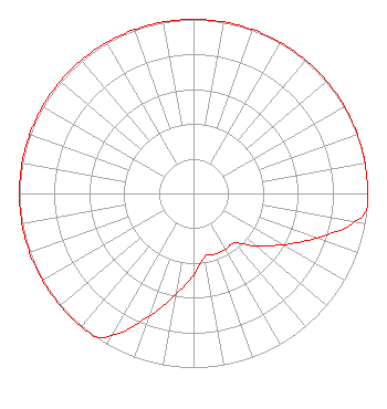 | ||||||||||||||||||
| Azimuth | Ratio | Azimuth | Ratio | Azimuth | Ratio | Azimuth | Ratio | ||||||||||||
| 0 | 1.000 | 10 | 1.000 | 20 | 1.000 | 30 | 1.000 | ||||||||||||
| 40 | 1.000 | 50 | 1.000 | 60 | 1.000 | 70 | 1.000 | ||||||||||||
| 80 | 1.000 | 90 | 1.000 | 95 | 1.000 | 100 | 0.940 | ||||||||||||
| 110 | 0.750 | 120 | 0.590 | 130 | 0.470 | 140 | 0.370 | ||||||||||||
| 150 | 0.370 | 160 | 0.370 | 170 | 0.370 | 180 | 0.470 | ||||||||||||
| 190 | 0.590 | 200 | 0.750 | 210 | 0.940 | 215 | 1.000 | ||||||||||||
| 220 | 1.000 | 230 | 1.000 | 240 | 1.000 | 250 | 1.000 | ||||||||||||
| 260 | 1.000 | 270 | 1.000 | 280 | 1.000 | 290 | 1.000 | ||||||||||||
| 300 | 1.000 | 310 | 1.000 | 320 | 1.000 | 330 | 1.000 | ||||||||||||
| 340 | 1.000 | 350 | 1.000 | ||||||||||||||||
Structure Registration Number 1034969 Structure Type: GTOWER Registered To: VB-S1 Assets, LLC Structure Address: 207 Hilltop Road / Us-la-5026 Fillmore, LA County Name: Bossier Parish ASR Issued: 07/21/2020 Date Built: 12/08/1997 Site Elevation: 121 m (397 ft.) Structure Height: 90 m (295 ft.) Height Overall: 90.8 m (298 ft.) Overall Height AMSL: 211.8 m (695 ft.) FAA Determination: 09/18/2019 FAA Study #: 2019-ASW-12695-OE FAA Circular #: 70/7460-1L Paint & Light FAA Chapters: 4, 8, 12 OM&L to remain the same as prior study = A MED-DUAL SYSTEM 32-33-16.5 N 93-31-47.6 W (NAD 83) 32-33-16.0 N 93-31-47.0 W (Converted to NAD 27) |
1211 Sw 5th Avenue Suite 750 Portland, OR 97204 Phone: 503-517-6200 | Date: 02/04/1998 Application Certifier NINETY-FIVE POINT SEVEN, INC. Ninety-five Point Seven, Inc. 7308 Old River Road Shreveport, LA 71105 Applicant | |||||||||||||||||
|
| ||||||||||||||||||