
FCCInfo.com
A Service of Cavell, Mertz & Associates, Inc.
(855) FCC-INFO
|
|
W252DJ from 06/07/2004 |
|
|
||||||||||||||||
|
|
W252DJ Channel: 252D 98.3 MHz Jacksonville Beach, Florida Service: FX - A translator or application for a translator. Facility ID: 139399 Fac. Service: FX Programming Delivery Method: Unspecified Status: License Application Accepted: 02/22/2019 Application Granted: 03/12/2019 File Number: BLFT-20190222ABV License Expires: 02/01/2028 Prefix Type: This is a license for a translator Application Type: License To Cover FCC Website Links: LMS Facility Details This Application CDBS Application Other W252DJ Applications Other W252DJ Applications in CDBS Including Superseded Applications Mailing Address Correspondence for W252DJ Correspondence related to application BLFT-20190222ABV Service Contour - Open Street Map or USGS Map (60 dBu) Service Contour - KML / Google Earth (60 dBu) Class: D, A Noncommercial educational operating with no more than 10W Site Location: 30-16-34.9 N 81-33-50.3 W (NAD 83) Site Location: 30-16-34.0 N 81-33-51.0 W (Converted to NAD 27) Effective Radiated Power: 0.11 kW Transmitter Output Power: 0.238 kW Antenna Center HAAT: 0 m Antenna Center AMSL: 269 m (883 ft.) Antenna Center HAG: 260 m (853 ft.) Site Elevation: 9 m. (30 ft.) Height Overall*: 323 m (1060 ft.) (* As Filed In This Application, may differ from ASR Data, Below.) Directional Antenna Antenna Make/Model: Systems With Reliability Inc. FMEC-1 Antenna ID: 123589 Polarization: H
| ||||||||||||||||||
| Antenna Data for Antenna Id: 123589 W252DJ FX File: BLFT-20190222ABV Systems With Reliability Inc. - FMEC-1 Service: FX | 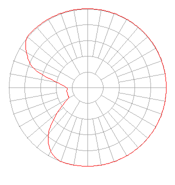 | ||||||||||||||||||
| Azimuth | Ratio | Azimuth | Ratio | Azimuth | Ratio | Azimuth | Ratio | ||||||||||||
| 0 | 1.000 | 10 | 1.000 | 20 | 1.000 | 30 | 1.000 | ||||||||||||
| 40 | 1.000 | 50 | 1.000 | 60 | 1.000 | 70 | 1.000 | ||||||||||||
| 80 | 1.000 | 90 | 1.000 | 100 | 1.000 | 110 | 1.000 | ||||||||||||
| 120 | 1.000 | 130 | 1.000 | 140 | 1.000 | 150 | 1.000 | ||||||||||||
| 160 | 1.000 | 170 | 1.000 | 180 | 1.000 | 190 | 1.000 | ||||||||||||
| 200 | 1.000 | 210 | 0.933 | 220 | 0.770 | 230 | 0.499 | ||||||||||||
| 240 | 0.289 | 250 | 0.267 | 260 | 0.267 | 270 | 0.267 | ||||||||||||
| 280 | 0.400 | 290 | 0.732 | 300 | 0.895 | 310 | 1.000 | ||||||||||||
| 320 | 1.000 | 330 | 1.000 | 340 | 1.000 | 350 | 1.000 | ||||||||||||
Structure Registration Number 1020783 Structure Type: GTOWER Registered To: American Towers, LLC Structure Address: 8541 Newton Rd (#302757) Jacksonville, FL County Name: Duval County ASR Issued: 02/07/2020 Date Built: 11/05/2008 Site Elevation: 9.1 m (30 ft.) Structure Height: 317.9 m (1043 ft.) Height Overall: 323.4 m (1061 ft.) Overall Height AMSL: 332.5 m (1091 ft.) FAA Determination: 12/02/2014 FAA Study #: 2014-ASO-12162-OE FAA Circular #: 70/7460-1K Paint & Light FAA Chapters: 4, 7, 12 PRIOR STUDY 2013-ASO-4505-OE 30-16-35.0 N 81-33-50.7 W (NAD 83) 30-16-34.1 N 81-33-51.4 W (Converted to NAD 27) |
5700 West Oaks Blvd Rocklin, CA 95765 Phone: 916-251-1600 Not-for-Profit | Date: 02/22/2019 Application Certifier EDUCATIONAL MEDIA FOUNDATION 5700 West Oaks Blvd. Rocklin, CA 95765 Applicant JAMES L TRAVIS 5700 W Oaks Blvd Rocklin, CA 95765 FCC COMPLIANCE ENGINEER MARY O'CONNOR Wilkinson Barker Knauer, Llp 1800 M Street, N.w. Suite 800n Washington, DC 20036 | |||||||||||||||||