
FCCInfo.com
A Service of Cavell, Mertz & Associates, Inc.
(855) FCC-INFO
|
|
|
|  |
|
|||||||||||||||
|
|
WAOY Channel: 219C1 91.7 MHz Gulfport, Mississippi Service: FM - A full-service FM station or application. Facility ID: 1533 Fac. Service: FM Status: License 73.215 Station Application Accepted: 10/29/1997 Application Granted: 02/26/1998 File Number: BLED-19971029KA License Expires: 00/00/0000 Prefix Type: This is a license for a noncommercial educational FM station Application Type: License To Cover FCC Website Links: LMS Facility Details This Application CDBS Application Other WAOY Applications Other WAOY Applications in CDBS Including Superseded Applications Mailing Address Correspondence for WAOY Correspondence related to application BLED-19971029KA Service Contour - Open Street Map or USGS Map (60 dBu) Service Contour - KML / Google Earth (60 dBu) Public Inspection Files Facility Type: NON-COMMERCIAL EDUC. FM Class: C1, A Zone II station; with 50kW-100kW ERP and a class contour distance 52km-72km Site Location: 30-42-29.7 N 89-05-06.2 W (NAD 83) Site Location: 30-42-29.0 N 89-05-06.0 W (Converted to NAD 27) Effective Radiated Power: 78 kW Transmitter Output Power: 17.5 kW Antenna Center HAAT: 332 m (1089 ft.) Antenna Center AMSL: 374 m (1227 ft.) Antenna Center HAG: 309 m (1014 ft.) Site Elevation: 65 m. (213 ft.) Height Overall*: 325 m (1066 ft.) (* As Filed In This Application, may differ from ASR Data, Below.) Directional Antenna Antenna Make/Model: Shivley 6810-12-SS-DA, half wavelength spacing Antenna ID: 14870 Polarization:
| ||||||||||||||||||
| Antenna Data for Antenna Id: 14870 WAOY FM File: BLED-19971029KA Shivley - 6810-12-SS-DA, half wavelength spacing Service: FM | 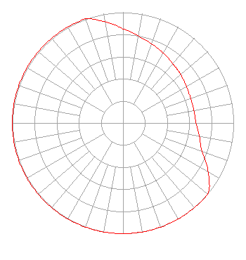 | ||||||||||||||||||
| Azimuth | Ratio | Azimuth | Ratio | Azimuth | Ratio | Azimuth | Ratio | ||||||||||||
| 0 | 0.850 | 10 | 0.800 | 20 | 0.760 | 30 | 0.730 | ||||||||||||
| 40 | 0.700 | 45 | 0.690 | 50 | 0.680 | 60 | 0.660 | ||||||||||||
| 70 | 0.650 | 80 | 0.650 | 90 | 0.660 | 100 | 0.700 | ||||||||||||
| 110 | 0.760 | 120 | 0.890 | 130 | 1.000 | 135 | 1.000 | ||||||||||||
| 140 | 1.000 | 150 | 1.000 | 160 | 1.000 | 170 | 1.000 | ||||||||||||
| 180 | 1.000 | 190 | 1.000 | 200 | 1.000 | 210 | 1.000 | ||||||||||||
| 220 | 1.000 | 225 | 1.000 | 230 | 1.000 | 240 | 1.000 | ||||||||||||
| 250 | 1.000 | 260 | 1.000 | 270 | 1.000 | 280 | 1.000 | ||||||||||||
| 290 | 1.000 | 300 | 1.000 | 310 | 1.000 | 315 | 1.000 | ||||||||||||
| 320 | 1.000 | 330 | 1.000 | 340 | 1.000 | 350 | 0.930 | ||||||||||||
| 355 | 0.890 | ||||||||||||||||||
Structure Registration Number 1054311 Structure Type: TOWER Registered To: AMERICAN FAMILY ASSOCIATION Structure Address: Township 4, South Range 11 West Section 9, 8.83 Km At 31.1 Degrees From Saucier Saucier, MS County Name: Stone County ASR Issued: 10/19/2009 Date Built: 06/01/1996 Site Elevation: 65 m (213 ft.) Structure Height: 325 m (1066 ft.) Height Overall: 325 m (1066 ft.) Overall Height AMSL: 390 m (1280 ft.) FAA Determination: 09/13/1995 FAA Study #: 95-ASO-2051-OE FAA Circular #: 70/7460-1H Paint & Light FAA Chapters: 4, 7, 13 30-42-30.0 N 89-05-06.0 W (NAD 83) 30-42-29.3 N 89-05-05.8 W (Converted to NAD 27) |
Po Box 2440 Tupelo, MS 38801-2440 Phone: 662-844-8888 Not-for-Profit | Date: 10/29/1997 Application Certifier AMERICAN FAMILY ASSOCIATION, INC. American Family Association, Inc. P.o. Drawer 2440 Tupelo, MS 38803 Applicant | |||||||||||||||||