
FCCInfo.com
A Service of Cavell, Mertz & Associates, Inc.
(855) FCC-INFO
|
|
|
|
|
||||||||||||||||
|
|
K225AR Channel: 225D 92.9 MHz Wenatchee, Washington Service: FX - A translator or application for a translator. Facility ID: 139113 Fac. Service: FX Programming Delivery Method: Unspecified Status: License Application Accepted: 10/20/2004 Application Granted: 11/10/2004 File Number: BLFT-20041020AAY License Expires: 00/00/0000 Prefix Type: This is a license for a translator Application Type: License To Cover FCC Website Links: LMS Facility Details This Application CDBS Application Other K225AR Applications Other K225AR Applications in CDBS Including Superseded Applications Mailing Address Correspondence for K225AR Correspondence related to application BLFT-20041020AAY Service Contour - Open Street Map or USGS Map (60 dBu) Service Contour - KML / Google Earth (60 dBu) Class: D, A Noncommercial educational operating with no more than 10W Site Location: 47-22-50.5 N 120-17-19.3 W (NAD 83) Site Location: 47-22-51.0 N 120-17-15.0 W (Converted to NAD 27) Effective Radiated Power: 0 kW Horiz. ; 0.09 kW Vert. Transmitter Output Power: 0.017 kW Antenna Center HAAT: 0 m Horiz.; -66 m Vert. Antenna Center AMSL: 0 m Horiz.; 627 m Vert. Antenna Center HAG: 0 m Horiz.; 11 m Vert. Site Elevation: 616 m. (2021 ft.) Height Overall*: 12 m (39 ft.) (* As Filed In This Application, may differ from ASR Data, Below.) Directional Antenna Antenna Make/Model: None Antenna ID: 31326 Polarization:
| ||||||||||||||||||
| Antenna Data for Antenna Id: 31326 K225AR FX File: BLFT-20041020AAY None - Service: FX Pattern and Field Values Include a 45° Clockwise Rotation | 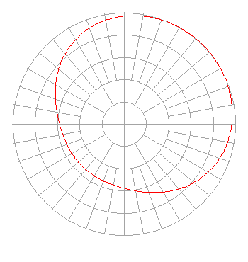 | ||||||||||||||||||
| Azimuth | Ratio | Azimuth | Ratio | Azimuth | Ratio | Azimuth | Ratio | ||||||||||||
| 5 | 0.975 | 15 | 0.987 | 25 | 0.995 | 35 | 0.999 | ||||||||||||
| 45 | 1.000 | 55 | 0.999 | 65 | 0.995 | 75 | 0.987 | ||||||||||||
| 85 | 0.975 | 95 | 0.956 | 105 | 0.929 | 115 | 0.892 | ||||||||||||
| 125 | 0.845 | 135 | 0.792 | 145 | 0.735 | 155 | 0.679 | ||||||||||||
| 165 | 0.630 | 175 | 0.592 | 185 | 0.566 | 195 | 0.549 | ||||||||||||
| 205 | 0.540 | 215 | 0.535 | 225 | 0.534 | 235 | 0.535 | ||||||||||||
| 245 | 0.540 | 255 | 0.549 | 265 | 0.566 | 275 | 0.592 | ||||||||||||
| 285 | 0.630 | 295 | 0.679 | 305 | 0.735 | 315 | 0.792 | ||||||||||||
| 325 | 0.845 | 335 | 0.892 | 345 | 0.929 | 355 | 0.956 | ||||||||||||
Structure Registration Number 1240500 Structure Type: POLE Registered To: BUTTERFIELD BROADCASTING CORP. Structure Address: Wenatchee Heights Wenatchee, WA County Name: Chelan County ASR Issued: 10/01/2003 Site Elevation: 616.3 m (2022 ft.) Structure Height: 12.2 m (40 ft.) Height Overall: 12.2 m (40 ft.) Overall Height AMSL: 628.5 m (2062 ft.) FAA Determination: 09/29/2003 FAA Study #: 2003-ANM-1800-OE FAA Circular #: Paint & Light FAA Chapters: NONE Removed expiration date from determination. Scenario 1./jjs/case#635066 47-22-50.5 N 120-17-19.3 W (NAD 83) 47-22-51.0 N 120-17-15.0 W (Converted to NAD 27) |
5110 Se Stark Street Portland, OR 97215 Phone: 503-233-5280 | Date: 10/20/2004 Application Certifier BUTTERFIELD BROADCASTING CORPORATION P.o. Box 2888 Yakima, WA 98907-2888 Applicant KEITH A. TESKE 706 Butterfield Road Yakima, WA 98901 EMPLOYEE KEITH TESKE Butterfield Broadcasting Corporation P.o. Box 2888 Yakima, WA 98907 | |||||||||||||||||