
FCCInfo.com
A Service of Cavell, Mertz & Associates, Inc.
(855) FCC-INFO
|
|
WFAN-FM from 07/25/2012 WFAN-FM from 07/21/2011 WFAN-FM from 02/05/2008 WFAN-FM from 08/10/1988 WFAN-FM from 08/28/1978 |
|  |
|
|||||||||||||||
|
|
WFAN-FM Channel: 270B 101.9 MHz New York, New York Service: FS - A full service FM station auxiliary transmitting antenna or application. Facility ID: 67846 Fac. Service: FM Analog & Digital Status: License Application Accepted: 01/29/2002 Application Granted: 10/24/2002 File Number: BXLH-20020129AAE License Expires: 00/00/0000 Prefix Type: This is BXLH Application Type: Amendment FCC Website Links: LMS Facility Details This Application CDBS Application Other WFAN-FM Applications Other WFAN-FM Applications in CDBS Including Superseded Applications Mailing Address Correspondence for WFAN-FM Correspondence related to application BXLH-20020129AAE Service Contour - Open Street Map or USGS Map (54 dBu) Service Contour - KML / Google Earth (54 dBu) Public Inspection Files History Cards for WFAN-FM Facility Type: FM STATION Class: B, A Zone I or I-A station; with 25kW-50kW ERP and a class contour distance 39km-52km Site Location: 40-47-17.4 N 74-15-17.5 W (NAD 83) Site Location: 40-47-17.0 N 74-15-19.0 W (Converted to NAD 27) Effective Radiated Power: 29.5 kW Transmitter Output Power: 7.9 kW Antenna Center HAAT: 194 m (636 ft.) Antenna Center AMSL: 259 m (850 ft.) Antenna Center HAG: 70 m (230 ft.) Site Elevation: 189 m. (620 ft.) Height Overall*: 92 m (302 ft.) (* As Filed In This Application, may differ from ASR Data, Below.) Directional Antenna Antenna Make/Model: Shivley 6814BB-5D-SS-DA, 5 SECTION, 0.5 WAVELENGTH Antenna ID: 36346 Polarization: | ||||||||||||||||||
| Antenna Data for Antenna Id: 36346 WFAN-FM FS File: BXLH-20020129AAE Shivley - 6814BB-5D-SS-DA, 5 SECTION, 0.5 WAVELENGTH Service: FS | 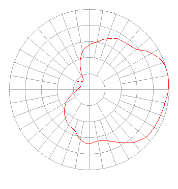 | ||||||||||||||||||
| Azimuth | Ratio | Azimuth | Ratio | Azimuth | Ratio | Azimuth | Ratio | ||||||||||||
| 0 | 0.550 | 10 | 0.600 | 20 | 0.670 | 30 | 0.725 | ||||||||||||
| 40 | 0.740 | 50 | 0.780 | 60 | 0.900 | 70 | 0.980 | ||||||||||||
| 80 | 1.000 | 90 | 0.990 | 100 | 0.965 | 110 | 0.950 | ||||||||||||
| 120 | 0.940 | 130 | 0.925 | 140 | 0.860 | 150 | 0.760 | ||||||||||||
| 160 | 0.680 | 170 | 0.650 | 180 | 0.675 | 190 | 0.630 | ||||||||||||
| 200 | 0.540 | 210 | 0.510 | 220 | 0.460 | 230 | 0.400 | ||||||||||||
| 240 | 0.330 | 250 | 0.250 | 260 | 0.180 | 270 | 0.140 | ||||||||||||
| 280 | 0.125 | 290 | 0.110 | 300 | 0.170 | 310 | 0.160 | ||||||||||||
| 320 | 0.130 | 330 | 0.150 | 340 | 0.320 | 350 | 0.475 | ||||||||||||
Structure Registration Number 1044879 Structure Type: LTOWER Registered To: American Towers LLC Structure Address: 12-16 Marcella Ave(282671) West Orange, NJ County Name: Essex County ASR Issued: 01/19/2015 Date Built: 05/31/2003 Site Elevation: 189 m (620 ft.) Structure Height: 91.4 m (300 ft.) Height Overall: 92.4 m (303 ft.) Overall Height AMSL: 281.4 m (923 ft.) FAA Determination: 10/23/2014 FAA Study #: 2014-AEA-6727-OE FAA Circular #: 70/7460-1K Paint & Light FAA Chapters: 4, 6, 12 PRIOR STUDY 2007-AEA-2741-OE 40-47-17.4 N 74-15-17.5 W (NAD 83) 40-47-17.0 N 74-15-19.0 W (Converted to NAD 27) |
2400 Market Street 4th Floor Philadelphia, PA 19103 Phone: 610-660-5610 Limited Liability Company | Date: 01/29/2002 Application Certifier EMMIS RADIO LICENSE CORPORATION 3500 West Olive Avenue Suite 300 Burbank, CA 91505 Applicant ROBERT CULVER Lohnes & Culver 8309 Cherry Lane Laurel, MD 20707 ENGINEERING CONSULTANT JOHN E. FIORINI, ESQ. Wiley Rein & Fielding Llp | |||||||||||||||||
| |||||||||||||||||||