
FCCInfo.com
A Service of Cavell, Mertz & Associates, Inc.
(855) FCC-INFO
|
|
|
|
|
||||||||||||||||
|
|
K285GL Channel: 285D 104.9 MHz Topeka, Kansas Service: FX - A translator or application for a translator. Facility ID: 156451 Fac. Service: FX Programming Delivery Method: Unspecified Status: License Application Accepted: 07/07/2016 Application Granted: 07/18/2016 File Number: BLFT-20160707AAG License Expires: 00/00/0000 Prefix Type: This is a license for a translator Application Type: License To Cover FCC Website Links: LMS Facility Details This Application CDBS Application Other K285GL Applications Other K285GL Applications in CDBS Including Superseded Applications Mailing Address Correspondence for K285GL Correspondence related to application BLFT-20160707AAG Service Contour - Open Street Map or USGS Map (60 dBu) Service Contour - KML / Google Earth (60 dBu) Class: D, A Noncommercial educational operating with no more than 10W Site Location: 39-03-50.0 N 95-45-49.9 W (NAD 83) Site Location: 39-03-50.0 N 95-45-49.0 W (Converted to NAD 27) Effective Radiated Power: 0.25 kW Transmitter Output Power: 0.494 kW Antenna Center HAAT: 0 m Antenna Center AMSL: 538 m (1765 ft.) Antenna Center HAG: 209 m (686 ft.) Site Elevation: 329 m. (1079 ft.) Height Overall*: 286 m (938 ft.) (* As Filed In This Application, may differ from ASR Data, Below.) Directional Antenna Antenna Make/Model: None Antenna ID: 124533 Polarization:
| ||||||||||||||||||
| Antenna Data for Antenna Id: 124533 K285GL FX File: BLFT-20160707AAG None - Service: FX | 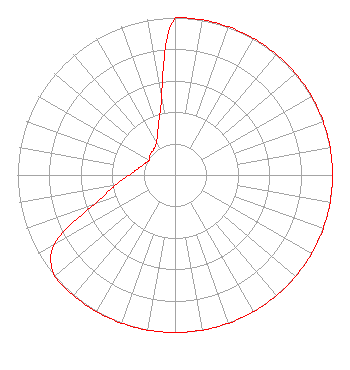 | ||||||||||||||||||
| Azimuth | Ratio | Azimuth | Ratio | Azimuth | Ratio | Azimuth | Ratio | ||||||||||||
| 0 | 1.000 | 10 | 1.000 | 20 | 1.000 | 30 | 1.000 | ||||||||||||
| 40 | 1.000 | 50 | 1.000 | 60 | 1.000 | 70 | 1.000 | ||||||||||||
| 80 | 1.000 | 90 | 1.000 | 100 | 1.000 | 110 | 1.000 | ||||||||||||
| 120 | 1.000 | 130 | 1.000 | 140 | 1.000 | 150 | 1.000 | ||||||||||||
| 160 | 1.000 | 170 | 1.000 | 180 | 1.000 | 190 | 1.000 | ||||||||||||
| 200 | 1.000 | 210 | 1.000 | 220 | 1.000 | 230 | 1.000 | ||||||||||||
| 240 | 0.883 | 250 | 0.547 | 260 | 0.388 | 270 | 0.292 | ||||||||||||
| 280 | 0.238 | 290 | 0.207 | 300 | 0.190 | 310 | 0.204 | ||||||||||||
| 320 | 0.211 | 330 | 0.237 | 340 | 0.314 | 350 | 0.498 | ||||||||||||
Structure Registration Number 1032651 Structure Type: Registered To: WASHBURN UNIVERSITY OF TOPEKA Structure Address: 301 Nw Wanamaker Road Topeka, KS County Name: Shawnee County ASR Issued: 01/02/2018 Date Built: 01/16/2004 Site Elevation: 329 m (1079 ft.) Structure Height: 265 m (869 ft.) Height Overall: 285.7 m (937 ft.) Overall Height AMSL: 614.7 m (2017 ft.) FAA Determination: 06/30/2000 FAA Study #: 00-ACE-0120-OE FAA Circular #: 70/7460-1K Paint & Light FAA Chapters: 3, 4, 5, 12 Removed final date from determination. Scenario 3./jjs/case#635066 39-03-50.0 N 95-45-50.0 W (NAD 83) 39-03-50.0 N 95-45-49.1 W (Converted to NAD 27) |
1211 Sw 5th Avenue Suite 750 Portland, OR 97204 Phone: 503-517-6200 Limited Liability Company | Date: 07/07/2016 Application Certifier ALPHA MEDIA LICENSEE LLC 1211 Sw 5th Avenue Suite 750 Portland, OR 97204 Applicant MICHAEL EVERHART 1211 Sw Fifth Avenue Michael Everhart Portland, OR 97204 DIRECTOR OF ENGINEERING GREGORY L. MASTERS Wiley Rein Llp 1776 K Street, Nw Washington, DC 20006 | |||||||||||||||||