
FCCInfo.com
A Service of Cavell, Mertz & Associates, Inc.
(855) FCC-INFO
|
|
|
Virtual Channel 20 |
|
||||||||||||||||||||||
|
|
Repacking Information: No changes Status: License Application Accepted: 02/22/2010 License Expires: 10/01/2014 File Number: BXLCDT-20100222ABT Prefix Type: This is BXLCDT FCC Website Links: LMS Facility Details This Application Other KTMW Applications Including Superseded Applications Mailing Address Correspondence for KTMW Correspondence related to application BXLCDT-20100222ABT Service Contour - Open Street Map or USGS Map (41 dBu) Service Contour - KML / Google Earth (41 dBu) Public Inspection Files Rabbit Ears Info Search for KTMW Site Location: 40-39-12.0 N 112-12-09.0 W (NAD 83) Site Location: 40-39-12.2 N 112-12-06.2 W (Converted to NAD 27) ERP: 55.3 kW Polarization: Horizontally polarized HAAT: 1171 m (3842 ft.) Electrical Beam Tilt: 1 degree R/C AGL: 59 m (194 ft.) R/C AMSL: 0 m Site Elevation: 2698 m. (8852 ft.) Height Overall*: 89 m (292 ft.) (* As Filed In This Application, may differ from ASR Data, Below.) Directional Antenna - Antenna Make/Model: DIELECTRIC TUP-SP2-12-1 & SP1-4-1 Antenna ID: 93134 Polarization: Horizontally polarized
| ||||||||||||||||||||||||
| Antenna Data for Antenna Id: 93134 KTMW DX File: BXLCDT-20100222ABT DIELECTRIC - TUP-SP2-12-1 & SP1-4-1 Service: DX Standard Pattern: Y | 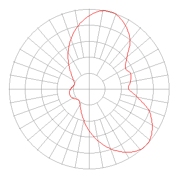 | ||||||||||||||||||||||||
| Azimuth | Ratio | Azimuth | Ratio | Azimuth | Ratio | Azimuth | Ratio | ||||||||||||||||||
| 0 | 0.914 | 10 | 0.992 | 15 | 1.000 | 20 | 0.990 | ||||||||||||||||||
| 30 | 0.911 | 40 | 0.795 | 50 | 0.619 | 60 | 0.526 | ||||||||||||||||||
| 70 | 0.552 | 80 | 0.525 | 90 | 0.494 | 100 | 0.617 | ||||||||||||||||||
| 110 | 0.795 | 120 | 0.911 | 130 | 0.990 | 135 | 1.000 | ||||||||||||||||||
| 140 | 0.992 | 150 | 0.914 | 160 | 0.797 | 170 | 0.660 | ||||||||||||||||||
| 180 | 0.523 | 190 | 0.392 | 200 | 0.291 | 210 | 0.226 | ||||||||||||||||||
| 220 | 0.191 | 230 | 0.201 | 240 | 0.230 | 250 | 0.249 | ||||||||||||||||||
| 260 | 0.249 | 270 | 0.230 | 280 | 0.201 | 290 | 0.191 | ||||||||||||||||||
| 300 | 0.225 | 310 | 0.290 | 320 | 0.392 | 330 | 0.523 | ||||||||||||||||||
| 340 | 0.660 | 350 | 0.797 | ||||||||||||||||||||||
Structure Registration Number 1040880 [ASR Heights Differ from KTMW Application] Structure Type: TOWER Registered To: SKAGGS COMPANIES INC DBA = SKAGGS TELECOMMUNICATIONS SERVICE Structure Address: Little Farnsworth Peak Tooele, UT County Name: Tooele County ASR Issued: 03/17/2010 Date Built: 01/15/2010 Site Elevation: 2698.4 m (8853 ft.) Structure Height: 68.8 m (226 ft.) Height Overall: 68.8 m (226 ft.) Overall Height AMSL: 2767.2 m (9079 ft.) FAA Determination: 12/24/2009 FAA Study #: 2009-ANM-2322-OE FAA Circular #: 70/7460-1K Paint & Light FAA Chapters: 4, 6, 12 PRIOR STUDY 2009-ANM-2179-OE 40-39-12.0 N 112-12-09.0 W (NAD 83) 40-39-12.2 N 112-12-06.2 W (Converted to NAD 27) |
300 New Jersey Avenue, Nw Suite 700 Washington, DC 20001 Phone: 202-524-6413 Limited Liability Company | Date: 02/22/2010 Application Certifier ALPHA & OMEGA COMMUNICATIONS, LLC 314 S. Redwood Rd. Salt Lake City, UT 84104 Applicant DENNIS SILVER Po Box 702392 West Valley City, UT 84170 PROFESSIONAL ENGINEER NATHANIEL J. HARDY, ESQ. Wood, Maines & Nolan, Pc 4600 Fairfax Dr. Suite 604 Arlington, VA 22203-1553 | |||||||||||||||||||||||
| |||||||||||||||||||||||||