
FCCInfo.com
A Service of Cavell, Mertz & Associates, Inc.
(855) FCC-INFO
|
|
KWET from 01/31/1983 |
Virtual Channel 12 |
|
||||||||||||||||
|
|
Repacking Information: No changes Status: License Application Accepted: 04/19/2012 License Expires: 06/01/2022 File Number: BLEDT-20120419ABL Prefix Type: This is a license for a noncommercial educational digital TV station FCC Website Links: LMS Facility Details This Application Other KWET Applications Including Superseded Applications Mailing Address Correspondence for KWET Correspondence related to application BLEDT-20120419ABL Service Contour - Open Street Map or USGS Map (36 dBu) Service Contour - KML / Google Earth (36 dBu) Public Inspection Files History Cards for KWET Rabbit Ears Info Search for KWET Site Location: 35-35-36.0 N 99-40-02.0 W (NAD 83) Site Location: 35-35-35.8 N 99-40-00.6 W (Converted to NAD 27) ERP: 60 kW Polarization: Horizontally polarized HAAT: 303.2 m (995 ft.) Electrical Beam Tilt: 1 degree R/C AGL: 292 m (958 ft.) R/C AMSL: 929.6 m (3050 ft.) Site Elevation: 637.6 m. (2092 ft.) Height Overall*: 304.4 m (999 ft.) (* As Filed In This Application, may differ from ASR Data, Below.) Directional Antenna - Antenna Make/Model: DIELECTRIC TF-12HT-DC-H Antenna ID: 108315 Polarization: Horizontally polarized | ||||||||||||||||||
| Antenna Data for Antenna Id: 108315 KWET DT File: BLEDT-20120419ABL DIELECTRIC - TF-12HT-DC-H Service: DT Standard Pattern: Y | 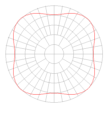 | ||||||||||||||||||
| Azimuth | Ratio | Azimuth | Ratio | Azimuth | Ratio | Azimuth | Ratio | ||||||||||||
| 0 | 0.807 | 10 | 0.830 | 20 | 0.888 | 30 | 0.952 | ||||||||||||
| 40 | 0.994 | 50 | 0.994 | 60 | 0.952 | 70 | 0.888 | ||||||||||||
| 80 | 0.830 | 90 | 0.807 | 100 | 0.830 | 110 | 0.888 | ||||||||||||
| 120 | 0.952 | 130 | 0.994 | 140 | 0.994 | 150 | 0.952 | ||||||||||||
| 160 | 0.888 | 170 | 0.830 | 180 | 0.807 | 190 | 0.830 | ||||||||||||
| 200 | 0.888 | 210 | 0.952 | 220 | 0.994 | 230 | 0.994 | ||||||||||||
| 240 | 0.952 | 250 | 0.888 | 260 | 0.830 | 270 | 0.807 | ||||||||||||
| 280 | 0.830 | 290 | 0.888 | 300 | 0.952 | 310 | 0.994 | ||||||||||||
| 320 | 0.994 | 330 | 0.952 | 340 | 0.888 | 350 | 0.830 | ||||||||||||
Structure Registration Number 1057889 Structure Type: TOWER Registered To: OKLAHOMA EDUCATIONAL TELEVISION AUTHORITY Structure Address: 1-95 Km S Cheyenne, OK County Name: Roger Mills County ASR Issued: 04/05/2012 Date Built: 01/01/1978 Site Elevation: 637.6 m (2092 ft.) Structure Height: 277 m (909 ft.) Height Overall: 304.4 m (999 ft.) Overall Height AMSL: 942 m (3091 ft.) Paint & Light FAA Chapters: A3, H 35-35-36.0 N 99-40-02.0 W (NAD 83) 35-35-35.8 N 99-40-00.6 W (Converted to NAD 27) |
7403 North Kelley Avenue Oklahoma City, OK 73111 Phone: 405-841-9250 Government Entity | Date: 04/19/2012 Application Certifier OKLAHOMA EDUCATIONAL TELEVISION AUTHORITY 7403 North Kelley Avenue Oklahoma City, OK 73113 Applicant DONALD G. EVERIST Cohen, Dippell And Everist, P.c. 1420 N Street, Nw Suite One Washington, DC 20005 CONSULTING ENGINEER BARRY S. PERSH Dow Lohnes Pllc 1200 New Hampshire Avenue Nw Suite 800 Washington, DC 20036 | |||||||||||||||||