
FCCInfo.com
A Service of Cavell, Mertz & Associates, Inc.
(855) FCC-INFO
|
|
KFTR-DT from 01/01/2004 KFTR-DT from 11/01/2001 KFTR-DT from 12/29/1992 KFTR-DT from 01/05/1987 KFTR-DT from 11/28/1983 |
Virtual Channel 46 |
|
|||||||||||||||||||
|
|
Repacking Information: No changes Status: License Application Accepted: 04/01/2010 License Expires: 12/01/2022 File Number: BLCDT-20100401AFY Prefix Type: This is a License for a commercial digital TV station FCC Website Links: LMS Facility Details This Application Other KFTR-DT Applications Including Superseded Applications Mailing Address Correspondence for KFTR-DT Correspondence related to application BLCDT-20100401AFY Service Contour - Open Street Map or USGS Map (41 dBu) Service Contour - KML / Google Earth (41 dBu) Public Inspection Files History Cards for KFTR-DT Rabbit Ears Info Search for KFTR-DT Site Location: 34-13-36.1 N 118-04-02.3 W (NAD 83) Site Location: 34-13-36.1 N 118-03-59.1 W (Converted to NAD 27) ERP: 370 kW Polarization: Elliptically polarized HAAT: 956 m (3136 ft.) Electrical Beam Tilt: 1.5 degrees R/C AGL: 98 m (322 ft.) R/C AMSL: 1839 m (6033 ft.) Site Elevation: 1741 m. (5712 ft.) Height Overall*: 107 m (351 ft.) (* As Filed In This Application, may differ from ASR Data, Below.) Directional Antenna - Antenna Make/Model: Electronics Research Inc. ATW22HS6-ETC1-29H Antenna ID: 96658 Polarization: Elliptically polarized | |||||||||||||||||||||
| Antenna Data for Antenna Id: 96658 KFTR-DT DT File: BLCDT-20100401AFY Electronics Research Inc. - ATW22HS6-ETC1-29H Service: DT Standard Pattern: Y | 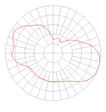 | |||||||||||||||||||||
| Azimuth | Ratio | Azimuth | Ratio | Azimuth | Ratio | Azimuth | Ratio | |||||||||||||||
| 0 | 0.289 | 10 | 0.301 | 20 | 0.335 | 30 | 0.292 | |||||||||||||||
| 40 | 0.296 | 50 | 0.417 | 60 | 0.533 | 70 | 0.650 | |||||||||||||||
| 80 | 0.833 | 90 | 0.946 | 100 | 0.997 | 110 | 1.000 | |||||||||||||||
| 120 | 0.975 | 130 | 0.901 | 140 | 0.783 | 150 | 0.682 | |||||||||||||||
| 160 | 0.636 | 170 | 0.614 | 180 | 0.608 | 190 | 0.599 | |||||||||||||||
| 200 | 0.585 | 210 | 0.580 | 220 | 0.578 | 230 | 0.570 | |||||||||||||||
| 240 | 0.592 | 250 | 0.704 | 260 | 0.828 | 270 | 0.861 | |||||||||||||||
| 280 | 0.828 | 290 | 0.896 | 300 | 0.925 | 310 | 0.856 | |||||||||||||||
| 320 | 0.742 | 330 | 0.677 | 340 | 0.603 | 350 | 0.444 | |||||||||||||||
Structure Registration Number 1232157 Structure Type: TOWER Registered To: Univision Television Group, Inc. Structure Address: Sited On Mt. Wilson (multiple Tall-tower Area) Pasadena, CA County Name: Los Angeles County ASR Issued: 10/18/2007 Date Built: 08/11/2002 Site Elevation: 1740.6 m (5711 ft.) Structure Height: 88.4 m (290 ft.) Height Overall: 106.7 m (350 ft.) Overall Height AMSL: 1847.3 m (6061 ft.) FAA Determination: 08/01/2001 FAA Study #: 01-AWP-2311-OE Paint & Light FAA Chapters: NONE Removed expiration date from determination. Scenario 1./jjs/case#635066 34-13-36.1 N 118-04-02.3 W (NAD 83) 34-13-36.1 N 118-03-59.1 W (Converted to NAD 27) |
101 Constitution Avenue, Nw, Suite 800w Washington, DC 20001 Phone: 310-348-3600 Limited Liability Company | Date: 04/01/2010 Application Certifier TELEFUTURA LOS ANGELES LLC 5999 Center Drive Los Angeles, CA 90045 Applicant KARL D. LAHM, P.E. Univision Management Co. P.o. Box 647 Lake Villa, IL 60046 DIRECTOR, RF SYSTEMS ENGINEERING ROBERT M. SHERMAN, ESQ. Covington & Burling Llp 1201 Pennsylvania Avenue, Nw Washington, DC 20004 | ||||||||||||||||||||
| ||||||||||||||||||||||