
FCCInfo.com
A Service of Cavell, Mertz & Associates, Inc.
(855) FCC-INFO
|
|
K17ED-D from 07/21/1995 |
|
|
||||||||||||||||
|
|
Repacking Information: No changes Status: License Application Accepted: 10/02/2014 License Expires: 10/01/2022 File Number: BLDTA-20141002AAE Prefix Type: This is BLDTA FCC Website Links: LMS Facility Details This Application Other K17ED-D Applications Including Superseded Applications Mailing Address Correspondence for K17ED-D Correspondence related to application BLDTA-20141002AAE Service Contour - Open Street Map or USGS Map (51 dBu) Service Contour - KML / Google Earth (51 dBu) Public Inspection Files Rabbit Ears Info Search for K17ED-D Site Location: 44-03-43.6 N 116-54-25.6 W (NAD 83) Site Location: 44-03-44.0 N 116-54-22.0 W (Converted to NAD 27) ERP: 13.65 kW R/C AGL: 114.1 m (374 ft.) R/C AMSL: m Emission Mask: Full Service Site Elevation: 755.9 m. (2480 ft.) Height Overall*: 123.4 m (405 ft.) (* As Filed In This Application, may differ from ASR Data, Below.) Directional Antenna - Antenna Make/Model: Jampro ODDK17ED Antenna ID: 115051 | ||||||||||||||||||
| Antenna Data for Antenna Id: 115051 K17ED-D DC File: BLDTA-20141002AAE Jampro - ODDK17ED Service: DC Standard Pattern: Y Pattern and Field Values Include a 260° Clockwise Rotation | 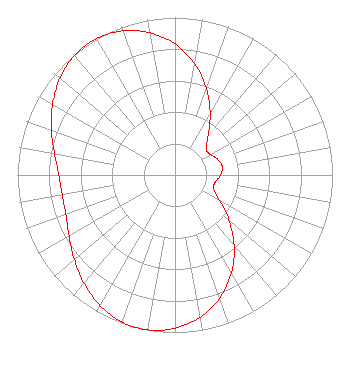 | ||||||||||||||||||
| Azimuth | Ratio | Azimuth | Ratio | Azimuth | Ratio | Azimuth | Ratio | ||||||||||||
| 0 | 0.832 | 10 | 0.716 | 20 | 0.584 | 30 | 0.446 | ||||||||||||
| 40 | 0.328 | 50 | 0.259 | 60 | 0.260 | 70 | 0.289 | ||||||||||||
| 80 | 0.305 | 90 | 0.289 | 100 | 0.260 | 110 | 0.259 | ||||||||||||
| 120 | 0.326 | 130 | 0.446 | 140 | 0.584 | 150 | 0.716 | ||||||||||||
| 160 | 0.832 | 170 | 0.918 | 180 | 0.973 | 190 | 0.999 | ||||||||||||
| 200 | 0.992 | 210 | 0.954 | 220 | 0.898 | 230 | 0.835 | ||||||||||||
| 240 | 0.777 | 250 | 0.738 | 260 | 0.728 | 270 | 0.738 | ||||||||||||
| 280 | 0.777 | 290 | 0.835 | 300 | 0.898 | 310 | 0.954 | ||||||||||||
| 320 | 0.992 | 330 | 0.999 | 340 | 0.973 | 350 | 0.918 | ||||||||||||
Structure Registration Number 1235627 Structure Type: TOWER Registered To: SUTRO CORPORATION Structure Address: S E Of Intersection Of Iowa Ave And State Hwy 52 Payette, ID County Name: Payette County ASR Issued: 08/27/2002 Date Built: 10/01/1982 Site Elevation: 755.9 m (2480 ft.) Structure Height: 122.5 m (402 ft.) Height Overall: 123.4 m (405 ft.) Overall Height AMSL: 879.3 m (2885 ft.) FAA Determination: 02/28/2000 FAA Study #: 99-ANM-1845-OE Paint & Light FAA Chapters: 1, 3, 4, 13, 21 PRIOR FAA 99-ANM-0221-OE CONTINUE OM&L PAINT/RED LIGHTS 44-03-43.6 N 116-54-25.6 W (NAD 83) 44-03-44.0 N 116-54-22.0 W (Converted to NAD 27) |
295 Madison Avenue, 12th Floor New York, NY 10017 Phone: 954-606-5486 Corporation | Date: 10/02/2014 Application Certifier THREE ANGELS BROADCASTING NETWORK, INC. P O Box 220 West Frankfort, IL 62896-0220 Applicant DANIEL N. PEEK Po Box 220 West Frankfort, IL 62896-0220 ENGINEER MOSES PRIMO 3abn | |||||||||||||||||