
FCCInfo.com
A Service of Cavell, Mertz & Associates, Inc.
(855) FCC-INFO
|
|
KUDF-LP from 04/08/1996 KUDF-LP from 02/28/1989 KUDF-LP from 03/07/1984 |
|
|
||||||||||||||||
|
|
Status: License Application Accepted: 11/01/2013 License Expires: 10/01/2022 File Number: BLDTL-20131101AIX Prefix Type: This is BLDTL FCC Website Links: LMS Facility Details This Application Other KUDF-LP Applications Including Superseded Applications Mailing Address Correspondence for KUDF-LP Correspondence related to application BLDTL-20131101AIX Service Contour - Open Street Map or USGS Map (51 dBu) Service Contour - KML / Google Earth (51 dBu) Rabbit Ears Info Search for KUDF-LP Site Location: 32-24-54.0 N 110-42-57.9 W (NAD 83) Site Location: 32-24-53.7 N 110-42-55.6 W (Converted to NAD 27) ERP: 3.02 kW Electrical Beam Tilt: 1.75 degrees R/C AGL: 53.6 m (176 ft.) R/C AMSL: 2642.6 m (8670 ft.) Emission Mask: Simple Site Elevation: 2589 m. (8494 ft.) Height Overall*: 78.9 m (259 ft.) (* As Filed In This Application, may differ from ASR Data, Below.) Directional Antenna - Antenna Make/Model: Electronics Research Inc. AL8WX-14-PL Antenna ID: 110937 | ||||||||||||||||||
| Antenna Data for Antenna Id: 110937 KUDF-LP LD File: BLDTL-20131101AIX Electronics Research Inc. - AL8WX-14-PL Service: LD Standard Pattern: Y Pattern and Field Values Include a 210° Clockwise Rotation | 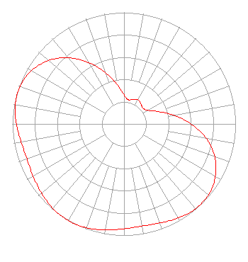 | ||||||||||||||||||
| Azimuth | Ratio | Azimuth | Ratio | Azimuth | Ratio | Azimuth | Ratio | ||||||||||||
| 0 | 0.260 | 10 | 0.220 | 20 | 0.235 | 30 | 0.250 | ||||||||||||
| 40 | 0.235 | 50 | 0.220 | 60 | 0.245 | 70 | 0.325 | ||||||||||||
| 80 | 0.450 | 90 | 0.600 | 100 | 0.750 | 110 | 0.865 | ||||||||||||
| 120 | 0.945 | 130 | 0.990 | 140 | 0.995 | 150 | 0.975 | ||||||||||||
| 160 | 0.945 | 170 | 0.930 | 180 | 0.940 | 190 | 0.965 | ||||||||||||
| 200 | 0.990 | 210 | 1.000 | 220 | 0.990 | 230 | 0.965 | ||||||||||||
| 240 | 0.940 | 250 | 0.925 | 260 | 0.935 | 270 | 0.965 | ||||||||||||
| 280 | 0.990 | 290 | 0.990 | 300 | 0.955 | 310 | 0.885 | ||||||||||||
| 320 | 0.775 | 330 | 0.635 | 340 | 0.490 | 350 | 0.360 | ||||||||||||
Structure Registration Number 1002407 Structure Type: LTOWER Registered To: American Towers LLC Structure Address: Mt. Bigelow, 1.4 Mi. N Of General Hitchcock (bigelow Mt. #9001) Coronado Natl Forest, AZ County Name: Pima County ASR Issued: 05/17/2017 Date Built: 01/01/1988 Site Elevation: 2589.1 m (8494 ft.) Structure Height: 66.4 m (218 ft.) Height Overall: 78.9 m (259 ft.) Overall Height AMSL: 2668 m (8753 ft.) FAA Determination: 10/31/2006 FAA Study #: 2006-AWP-5792-OE FAA Circular #: 70/7460-1K Paint & Light FAA Chapters: 3, 4, 5, 12 OM&L to remain the same as prior study = PAINT/RED LIGHTS 32-24-54.0 N 110-42-57.9 W (NAD 83) 32-24-53.7 N 110-42-55.6 W (Converted to NAD 27) |
1201 East Broadway Blvd. Tucson, AZ 85719 Phone: 520-312-5631 Corporation | Date: 11/01/2013 Application Certifier LM MEDIA GROUP, INC. 1201 East Broadway Blvd. Tucson, AZ 85719 Applicant JORGE L. ARREDONDO 1201 East Broadway Blvd. Tucson, AZ 85719 CONSULTING ENGINEER FRANCISCO R. MONTERO Fletcher, Heald & Hildreth, Plc | |||||||||||||||||
| |||||||||||||||||||