
FCCInfo.com
A Service of Cavell, Mertz & Associates, Inc.
(855) FCC-INFO
|
|
|
Virtual Channel 28 |
|
|||||||||||||||||||
|
|
Repacking Information: No changes Status: License Application Accepted: 06/26/2006 License Expires: 08/01/2022 File Number: BLCDT-20060626ACE Prefix Type: This is a License for a commercial digital TV station FCC Website Links: LMS Facility Details This Application Other KORO Applications Including Superseded Applications Mailing Address Correspondence for KORO Correspondence related to application BLCDT-20060626ACE Service Contour - Open Street Map or USGS Map (41 dBu) Service Contour - KML / Google Earth (41 dBu) Public Inspection Files History Cards for KORO Rabbit Ears Info Search for KORO Site Location: 27-42-29.0 N 97-38-00.0 W (NAD 83) Site Location: 27-42-27.9 N 97-37-59.0 W (Converted to NAD 27) ERP: 1000 kW Polarization: Horizontally polarized HAAT: 287.3 m (943 ft.) Electrical Beam Tilt: 1.25 degrees R/C AGL: 284.6 m (934 ft.) R/C AMSL: 302.9 m (994 ft.) Site Elevation: 18.3 m. (60 ft.) Height Overall*: 301.4 m (989 ft.) (* As Filed In This Application, may differ from ASR Data, Below.) Directional Antenna - Antenna Make/Model: Andrew ATW27H3-HTOCU-28H Antenna ID: 38420 Polarization: Horizontally polarized | |||||||||||||||||||||
| Antenna Data for Antenna Id: 38420 KORO DT File: BLCDT-20060626ACE Andrew - ATW27H3-HTOCU-28H Service: DT Standard Pattern: Y | 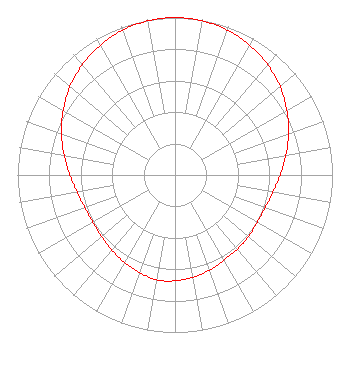 | |||||||||||||||||||||
| Azimuth | Ratio | Azimuth | Ratio | Azimuth | Ratio | Azimuth | Ratio | |||||||||||||||
| 0 | 1.000 | 10 | 0.994 | 20 | 0.978 | 30 | 0.951 | |||||||||||||||
| 40 | 0.915 | 50 | 0.871 | 60 | 0.820 | 70 | 0.767 | |||||||||||||||
| 80 | 0.715 | 90 | 0.668 | 100 | 0.631 | 110 | 0.609 | |||||||||||||||
| 120 | 0.602 | 130 | 0.608 | 140 | 0.615 | 150 | 0.623 | |||||||||||||||
| 160 | 0.642 | 170 | 0.659 | 180 | 0.672 | 190 | 0.676 | |||||||||||||||
| 200 | 0.659 | 210 | 0.642 | 220 | 0.623 | 230 | 0.608 | |||||||||||||||
| 240 | 0.602 | 250 | 0.609 | 260 | 0.631 | 270 | 0.668 | |||||||||||||||
| 280 | 0.715 | 290 | 0.767 | 300 | 0.820 | 310 | 0.871 | |||||||||||||||
| 320 | 0.915 | 330 | 0.951 | 340 | 0.978 | 350 | 0.994 | |||||||||||||||
Structure Registration Number 1218044 Structure Type: GTOWER Registered To: SBA Towers II LLC Structure Address: 3333 Co Road 28 (tx11751-a) Robstown, TX County Name: Nueces County ASR Issued: 11/08/2018 Date Built: 06/23/2000 Site Elevation: 18.3 m (60 ft.) Structure Height: 278 m (912 ft.) Height Overall: 301.1 m (988 ft.) Overall Height AMSL: 319.4 m (1048 ft.) FAA Determination: 11/05/2018 FAA Study #: 2018-ASW-12968-OE FAA Circular #: 70/7460-1L Paint & Light FAA Chapters: 3, 4, 5, 12 PRIOR STUDY 1999-ASW-4790-OE 27-42-29.0 N 97-37-59.9 W (NAD 83) 27-42-27.9 N 97-37-58.9 W (Converted to NAD 27) |
2425 Olympic Blvd Ste 6000 W Santa Monica, CA 90404 Phone: 310-447-3870 Limited Liability Company | Date: 06/26/2006 Application Certifier ENTRAVISION HOLDINGS, LLC Suite 6000 West 2425 Olympic Boulevard Santa Monica, CA 90404 Applicant MANUEL CAVAZOS III 801 N. Jackson Mcallen, TX 78501 DIRECTOR OF ENGINEERING BARRY A. FRIEDMAN Thompson Hine Llp Suite 800 1920 N Street, N.w. Washington, DC 20036 | ||||||||||||||||||||
|
| |||||||||||||||||||||