
FCCInfo.com
A Service of Cavell, Mertz & Associates, Inc.
(855) FCC-INFO
|
|
|
Virtual Channel 4 |  |
|
||||||||||||||||||||||||||||||
|
|
Status: License Application Accepted: 12/05/2013 License Expires: 02/01/2015 File Number: BLCDT-20131205AIL Prefix Type: This is a License for a commercial digital TV station FCC Website Links: LMS Facility Details This Application Other KPIC Applications Including Superseded Applications Mailing Address Correspondence for KPIC Correspondence related to application BLCDT-20131205AIL Service Contour - Open Street Map or USGS Map (51 dBu) Service Contour - KML / Google Earth (51 dBu) History Cards for KPIC Rabbit Ears Info Search for KPIC Site Location: 43-12-21.0 N 123-21-53.0 W (NAD 83) Site Location: 43-12-21.6 N 123-21-48.7 W (Converted to NAD 27) ERP: 0.478 kW R/C AGL: 20 m (66 ft.) R/C AMSL: 375.2 m (1231 ft.) Emission Mask: Simple Site Elevation: 355.2 m. (1165 ft.) Height Overall*: 21.3 m (70 ft.) (* As Filed In This Application, may differ from ASR Data, Below.) Directional Antenna - Antenna Make/Model: Scala 4DR-4-2HW Antenna ID: 20741
| |||||||||||||||||||||||||||||||||
| Antenna Data for Antenna Id: 20741 KPIC LD File: BLCDT-20131205AIL Scala - 4DR-4-2HW Service: LD Standard Pattern: Y Pattern and Field Values Include a 45° Clockwise Rotation | 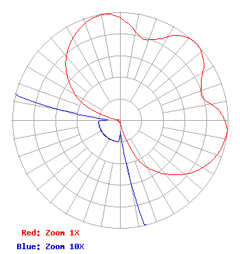 | |||||||||||||||||||||||||||||||||
| Azimuth | Ratio | Azimuth | Ratio | Azimuth | Ratio | Azimuth | Ratio | |||||||||||||||||||||||||||
| 5 | 0.895 | 15 | 0.784 | 25 | 0.827 | 35 | 0.955 | |||||||||||||||||||||||||||
| 45 | 1.000 | 55 | 0.945 | 65 | 0.830 | 75 | 0.795 | |||||||||||||||||||||||||||
| 85 | 0.925 | 95 | 0.995 | 105 | 0.975 | 115 | 0.920 | |||||||||||||||||||||||||||
| 125 | 0.835 | 135 | 0.715 | 145 | 0.580 | 155 | 0.410 | |||||||||||||||||||||||||||
| 165 | 0.135 | 175 | 0.020 | 185 | 0.020 | 195 | 0.020 | |||||||||||||||||||||||||||
| 205 | 0.020 | 215 | 0.020 | 225 | 0.020 | 235 | 0.020 | |||||||||||||||||||||||||||
| 245 | 0.020 | 255 | 0.020 | 265 | 0.020 | 275 | 0.020 | |||||||||||||||||||||||||||
| 285 | 0.130 | 295 | 0.395 | 305 | 0.560 | 315 | 0.710 | |||||||||||||||||||||||||||
| 325 | 0.825 | 335 | 0.915 | 345 | 0.975 | 355 | 0.983 | |||||||||||||||||||||||||||
Structure Registration Number 1039827 Structure Type: TOWER Registered To: PETERSON, KEITH A Structure Address: At The End Of Fairhill Dr Roseburg, OR County Name: Douglas County ASR Issued: 03/06/1998 Date Built: 01/01/1994 Site Elevation: 355.2 m (1165 ft.) Structure Height: 15.2 m (50 ft.) Height Overall: 21.3 m (70 ft.) Overall Height AMSL: 376.5 m (1235 ft.) FAA Determination: 05/25/1994 FAA Study #: 94-ANM-0464-OE FAA Circular #: 70/7460-1H Paint & Light FAA Chapters: 4, 5, 13 43-12-21.0 N 123-21-53.0 W (NAD 83) 43-12-21.6 N 123-21-48.7 W (Converted to NAD 27) |
C/o Miles S. Mason, Esq. - Pillsbury Winthrop 1200 Seventeenth Street, Nw Washington, DC 20036 Phone: 202-663-8195 Corporation | Date: 12/05/2013 Application Certifier KPIC LICENSEE, LLC C/o Clifford Harrington, Pillsbury Winth 2300 N Street, Nw Washington, DC 20037 Applicant ROBERT L. OLSON 621 Wilson Road Yuba City, CA 95991 CONSULTING ENGINEER CLIFFORD M. HARRINGTON, ESQ. Pillsbury Winthrop Shawpittman Llc | ||||||||||||||||||||||||||||||||
| ||||||||||||||||||||||||||||||||||