
FCCInfo.com
A Service of Cavell, Mertz & Associates, Inc.
(855) FCC-INFO
|
|
KSVT-LD from 10/09/2012 KSVT-LD from 03/16/2007 |
|
|
||||||||||||||||
|
|
Status: License Application Accepted: 07/02/2012 License Expires: 10/01/2022 File Number: BLDTL-20120702AAO Prefix Type: This is BLDTL FCC Website Links: LMS Facility Details This Application Other KSVT-LD Applications Including Superseded Applications Mailing Address Correspondence for KSVT-LD Correspondence related to application BLDTL-20120702AAO Service Contour - Open Street Map or USGS Map (51 dBu) Service Contour - KML / Google Earth (51 dBu) Rabbit Ears Info Search for KSVT-LD Site Location: 42-43-47.0 N 114-24-55.0 W (NAD 83) Site Location: 42-43-47.3 N 114-24-51.9 W (Converted to NAD 27) ERP: 15 kW Electrical Beam Tilt: 1 degree R/C AGL: 49 m (161 ft.) R/C AMSL: 1359 m (4459 ft.) Emission Mask: Simple Site Elevation: 1310 m. (4298 ft.) Height Overall*: 208 m (682 ft.) (* As Filed In This Application, may differ from ASR Data, Below.) Directional Antenna - Antenna Make/Model: DIELECTRIC TLP-8F Antenna ID: 76282 | ||||||||||||||||||
| Antenna Data for Antenna Id: 76282 KSVT-LD LD File: BLDTL-20120702AAO DIELECTRIC - TLP-8F Service: LD Standard Pattern: Y Pattern and Field Values Include a 235° Clockwise Rotation | 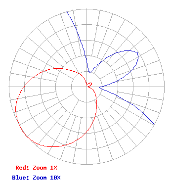 | ||||||||||||||||||
| Azimuth | Ratio | Azimuth | Ratio | Azimuth | Ratio | Azimuth | Ratio | ||||||||||||
| 5 | 0.023 | 12 | 0.019 | 15 | 0.019 | 25 | 0.028 | ||||||||||||
| 35 | 0.045 | 45 | 0.064 | 55 | 0.077 | 57 | 0.078 | ||||||||||||
| 65 | 0.071 | 75 | 0.051 | 85 | 0.028 | 95 | 0.017 | ||||||||||||
| 105 | 0.035 | 115 | 0.080 | 125 | 0.125 | 135 | 0.168 | ||||||||||||
| 145 | 0.224 | 155 | 0.304 | 165 | 0.409 | 175 | 0.525 | ||||||||||||
| 185 | 0.640 | 195 | 0.750 | 205 | 0.849 | 215 | 0.932 | ||||||||||||
| 225 | 0.987 | 235 | 1.000 | 245 | 0.983 | 255 | 0.939 | ||||||||||||
| 265 | 0.850 | 275 | 0.745 | 285 | 0.634 | 295 | 0.521 | ||||||||||||
| 305 | 0.405 | 315 | 0.296 | 325 | 0.223 | 335 | 0.165 | ||||||||||||
| 345 | 0.101 | 355 | 0.049 | ||||||||||||||||
Structure Registration Number 1040035 Structure Type: TOWER Registered To: Gray Media Group, Inc. Structure Address: On Flat Top Butte, 5 Miles East Of Jerome, ID County Name: Jerome County ASR Issued: 09/09/2020 Date Built: 12/01/1961 Site Elevation: 1309.7 m (4297 ft.) Structure Height: 183.6 m (602 ft.) Height Overall: 207.8 m (682 ft.) Overall Height AMSL: 1517.5 m (4979 ft.) FAA Determination: 01/16/1998 FAA Study #: 98-ANM-0006-OE FAA Circular #: 70/7460-1J Paint & Light FAA Chapters: 3, 4, 5, 13 Removed expiration date from determination. Scenario 1./jjs/case#635066 42-43-47.0 N 114-24-55.0 W (NAD 83) 42-43-47.3 N 114-24-51.9 W (Converted to NAD 27) |
4370 Peachtree Rd Ne Atlanta, GA 30319 Phone: 404-504-9828 Applicant | Date: 07/02/2012 Application Certifier NEUHOFF FAMILY LIMITED PARTNERSHIP 1340 Us Highway One #135 Jupiter, FL 33469 Applicant RYAN WILHOUR 507 Nw 60th Street Suite C Gainesville, FL 32607 CONSULTING ENGINEER MALCOLM G. STEVENSON Schwartz, Woods & Miller | |||||||||||||||||