
FCCInfo.com
A Service of Cavell, Mertz & Associates, Inc.
(855) FCC-INFO
|
|
K27AI-D from 04/07/1993 K27AI-D from 04/27/1993 |
|
|
||||||||||||||||
|
|
Status: License Application Accepted: 06/12/2012 License Expires: 02/01/2023 File Number: BLDTT-20120612ABI Prefix Type: This is BLDTT FCC Website Links: LMS Facility Details This Application Other K27AI-D Applications Including Superseded Applications Mailing Address Correspondence for K27AI-D Correspondence related to application BLDTT-20120612ABI Service Contour - Open Street Map or USGS Map (51 dBu) Service Contour - KML / Google Earth (51 dBu) Rabbit Ears Info Search for K27AI-D Site Location: 60-00-36.8 N 151-42-46.0 W (NAD 83) Site Location: 60-00-39.0 N 151-42-38.1 W (Converted to NAD 27) ERP: 0.11 kW R/C AGL: 75 m (246 ft.) R/C AMSL: 146.9 m (482 ft.) Emission Mask: Simple Site Elevation: 71.9 m. (236 ft.) Height Overall*: 91.5 m (300 ft.) (* As Filed In This Application, may differ from ASR Data, Below.) Directional Antenna - Antenna Make/Model: Scala TWO PR-TV-27/50 Antenna ID: 109242
| ||||||||||||||||||
| Antenna Data for Antenna Id: 109242 K27AI-D LD File: BLDTT-20120612ABI Scala - TWO PR-TV-27/50 Service: LD Standard Pattern: Y | 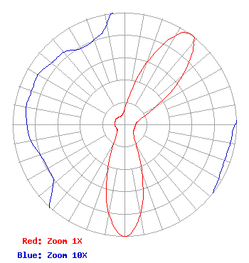 | ||||||||||||||||||
| Azimuth | Ratio | Azimuth | Ratio | Azimuth | Ratio | Azimuth | Ratio | ||||||||||||
| 0 | 0.134 | 10 | 0.266 | 20 | 0.590 | 30 | 0.913 | ||||||||||||
| 36 | 1.000 | 40 | 0.958 | 50 | 0.674 | 60 | 0.336 | ||||||||||||
| 70 | 0.169 | 80 | 0.115 | 90 | 0.099 | 100 | 0.096 | ||||||||||||
| 110 | 0.095 | 120 | 0.097 | 130 | 0.103 | 140 | 0.130 | ||||||||||||
| 150 | 0.204 | 160 | 0.458 | 170 | 0.818 | 180 | 1.000 | ||||||||||||
| 190 | 0.808 | 200 | 0.442 | 210 | 0.184 | 220 | 0.111 | ||||||||||||
| 230 | 0.083 | 240 | 0.079 | 250 | 0.080 | 260 | 0.085 | ||||||||||||
| 270 | 0.087 | 280 | 0.089 | 290 | 0.088 | 300 | 0.089 | ||||||||||||
| 310 | 0.085 | 320 | 0.084 | 330 | 0.078 | 340 | 0.080 | ||||||||||||
| 350 | 0.091 | ||||||||||||||||||
Structure Registration Number 1003111 [ASR Heights Differ from K27AI-D Application] Structure Type: LTOWER Registered To: State of Alaska Structure Address: W Of Sterling Hwy At Mile 138 Ninilchik, AK County Name: Kenai Peninsula Borough ASR Issued: 09/10/2015 Date Built: 04/13/2015 Site Elevation: 71.9 m (236 ft.) Structure Height: 91.5 m (300 ft.) Height Overall: 93.6 m (307 ft.) Overall Height AMSL: 165.5 m (543 ft.) FAA Determination: 03/26/2015 FAA Study #: 2015-AAL-77-OE FAA Circular #: 70/7460-1K Paint & Light FAA Chapters: 4, 8, 12 OM&L to remain the same as prior study = A MED-DUAL SYSTEM 60-00-36.8 N 151-42-46.0 W (NAD 83) 60-00-39.0 N 151-42-38.1 W (Converted to NAD 27) |
4370 Peachtree Road, Ne Atlanta, GA 30319 Phone: 404-266-8333 Applicant | Date: 06/12/2012 Application Certifier NORTHERN LIGHTS MEDIA, INC. 701 E. Tudor Road Suite 220 Anchorage, AK 99503-7488 Applicant DANIEL G. RYSON Cavell, Mertz & Associates, Inc. 7732 Donegan Dr. Manassas, VA 20109-2868 CONSULTANT JACK N. GOODMAN, ESQ. Law Offices Of Jack N Goodman | |||||||||||||||||