
FCCInfo.com
A Service of Cavell, Mertz & Associates, Inc.
(855) FCC-INFO
|
|
|
Virtual Channel 25 |  |
|
||||||||||||||||||
|
|
Repacking Information: No changes Status: License Application Accepted: 02/07/2006 License Expires: 04/01/2022 File Number: BLEDT-20060207ABL Prefix Type: This is a license for a noncommercial educational digital TV station FCC Website Links: LMS Facility Details This Application Other KMDE Applications Including Superseded Applications Mailing Address Correspondence for KMDE Correspondence related to application BLEDT-20060207ABL Service Contour - Open Street Map or USGS Map (41 dBu) Service Contour - KML / Google Earth (41 dBu) Public Inspection Files Rabbit Ears Info Search for KMDE Site Location: 48-03-47.8 N 99-20-10.2 W (NAD 83) Site Location: 48-03-47.8 N 99-20-08.7 W (Converted to NAD 27) ERP: 134 kW Polarization: Horizontally polarized HAAT: 244.5 m (802 ft.) Electrical Beam Tilt: 0.75 degrees R/C AGL: 222.2 m (729 ft.) R/C AMSL: 716.3 m (2350 ft.) Site Elevation: 494.1 m. (1621 ft.) Height Overall*: 232.2 m (762 ft.) (* As Filed In This Application, may differ from ASR Data, Below.) Directional Antenna - Antenna Make/Model: DIELECTRIC TFU-30GTH-R 04 Antenna ID: 66852 Polarization: Horizontally polarized | |||||||||||||||||||||
| Antenna Data for Antenna Id: 66852 KMDE DT File: BLEDT-20060207ABL DIELECTRIC - TFU-30GTH-R 04 Service: DT Standard Pattern: Y | 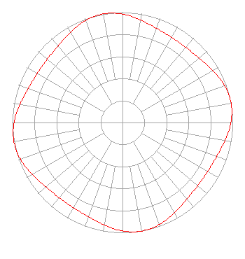 | |||||||||||||||||||||
| Azimuth | Ratio | Azimuth | Ratio | Azimuth | Ratio | Azimuth | Ratio | |||||||||||||||
| 0 | 0.983 | 10 | 0.943 | 20 | 0.908 | 30 | 0.891 | |||||||||||||||
| 40 | 0.891 | 50 | 0.908 | 60 | 0.943 | 70 | 0.983 | |||||||||||||||
| 80 | 1.000 | 90 | 0.983 | 100 | 0.943 | 110 | 0.908 | |||||||||||||||
| 120 | 0.891 | 130 | 0.891 | 140 | 0.908 | 150 | 0.943 | |||||||||||||||
| 160 | 0.983 | 170 | 1.000 | 180 | 0.983 | 190 | 0.943 | |||||||||||||||
| 200 | 0.908 | 210 | 0.891 | 220 | 0.891 | 230 | 0.908 | |||||||||||||||
| 240 | 0.943 | 250 | 0.983 | 260 | 1.000 | 270 | 0.983 | |||||||||||||||
| 280 | 0.943 | 290 | 0.908 | 300 | 0.891 | 310 | 0.891 | |||||||||||||||
| 320 | 0.908 | 330 | 0.943 | 340 | 0.983 | 350 | 1.000 | |||||||||||||||
Structure Registration Number 1246091 Structure Type: TOWER Registered To: Prairie Public Broadcasting, Inc. Structure Address: 6.4 Km West Of Minnewaukan, Benson County, North Dakota Minnewaukan, ND County Name: Benson County ASR Issued: 11/15/2004 Date Built: 11/03/2005 Site Elevation: 494.1 m (1621 ft.) Structure Height: 213.4 m (700 ft.) Height Overall: 232.2 m (762 ft.) Overall Height AMSL: 726.3 m (2383 ft.) FAA Determination: 10/05/2004 FAA Study #: 2004-AGL-3070-OE FAA Circular #: 70/7460-1K Paint & Light FAA Chapters: 3, 4, 5, 12 Removed expiration and final dates from determination. Scenario 2./jjs/case#635066 48-03-47.8 N 99-20-10.2 W (NAD 83) 48-03-47.8 N 99-20-08.7 W (Converted to NAD 27) |
P.o. Box 3240 Fargo, ND 58108 Phone: 701-241-6900 Not-for-Profit | Date: 02/07/2006 Application Certifier PRAIRIE PUBLIC BROADCASTING, INC. Po Box 3240 Fargo, ND 58108-3240 Applicant JIM SOLUM P.o. Box 3240 Fargo, ND 58108 EMPLOYEE MARGARET L. MILLER, ESQUIRE Dow, Lohnes & Albertson, Pllc | ||||||||||||||||||||
| ||||||||||||||||||||||