
FCCInfo.com
A Service of Cavell, Mertz & Associates, Inc.
(855) FCC-INFO
|
|
K24GD-D from 07/31/2003 K24GD-D from 08/26/1993 K24GD-D from 04/29/1980 |
|
|
||||||||||||||||
|
|
Status: License Application Accepted: 09/07/2010 License Expires: 04/01/2022 File Number: BLDTL-20100907ACF Prefix Type: This is BLDTL FCC Website Links: LMS Facility Details This Application Other K24GD-D Applications Including Superseded Applications Mailing Address Correspondence for K24GD-D Correspondence related to application BLDTL-20100907ACF Service Contour - Open Street Map or USGS Map (51 dBu) Service Contour - KML / Google Earth (51 dBu) Rabbit Ears Info Search for K24GD-D Site Location: 45-44-44.0 N 107-32-13.0 W (NAD 83) Site Location: 45-44-44.1 N 107-32-10.7 W (Converted to NAD 27) ERP: 0.322 kW Electrical Beam Tilt: 1.75 degrees R/C AGL: 17 m (56 ft.) R/C AMSL: 1010.3 m (3315 ft.) Emission Mask: Simple Site Elevation: 993.3 m. (3259 ft.) Height Overall*: 18.9 m (62 ft.) (* As Filed In This Application, may differ from ASR Data, Below.) Directional Antenna - Antenna Make/Model: Scala SL-8 Antenna ID: 96442 | ||||||||||||||||||
| Antenna Data for Antenna Id: 96442 K24GD-D LD File: BLDTL-20100907ACF Scala - SL-8 Service: LD Standard Pattern: Y Pattern and Field Values Include a 260° Clockwise Rotation | 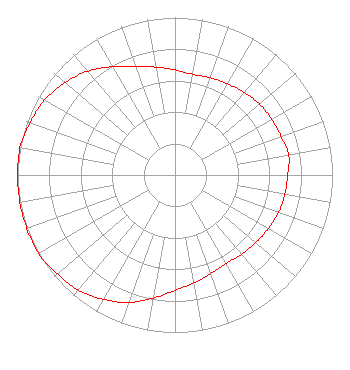 | ||||||||||||||||||
| Azimuth | Ratio | Azimuth | Ratio | Azimuth | Ratio | Azimuth | Ratio | ||||||||||||
| 0 | 0.668 | 10 | 0.649 | 20 | 0.657 | 30 | 0.668 | ||||||||||||
| 40 | 0.684 | 50 | 0.700 | 60 | 0.708 | 70 | 0.716 | ||||||||||||
| 80 | 0.733 | 90 | 0.716 | 100 | 0.708 | 110 | 0.700 | ||||||||||||
| 120 | 0.684 | 130 | 0.668 | 140 | 0.657 | 150 | 0.649 | ||||||||||||
| 160 | 0.668 | 170 | 0.696 | 180 | 0.733 | 190 | 0.794 | ||||||||||||
| 200 | 0.861 | 210 | 0.912 | 220 | 0.955 | 230 | 0.977 | ||||||||||||
| 240 | 1.000 | 250 | 1.000 | 260 | 1.000 | 270 | 1.000 | ||||||||||||
| 280 | 1.000 | 290 | 0.977 | 300 | 0.955 | 310 | 0.912 | ||||||||||||
| 320 | 0.861 | 330 | 0.794 | 340 | 0.733 | 350 | 0.696 | ||||||||||||
Structure Registration Number 1062459 Structure Type: TOWER Registered To: Scripps Broadcasting Holdings LLC Structure Address: 6.4 Km E Off Sarpy Rd Hardin, MT County Name: Big Horn County ASR Issued: 05/02/2019 Date Built: 01/01/1993 Site Elevation: 993.3 m (3259 ft.) Structure Height: 12.2 m (40 ft.) Height Overall: 18.9 m (62 ft.) Overall Height AMSL: 1012.2 m (3321 ft.) FAA Determination: 03/10/1999 FAA Study #: 99-ANM-0152-OE Paint & Light FAA Chapters: NONE Removed expiration date from determination. Scenario 1./jjs/case#635066 45-44-44.0 N 107-32-13.0 W (NAD 83) 45-44-44.1 N 107-32-10.7 W (Converted to NAD 27) |
C/o Scripps Media, Inc. 312 Walnut St 28th Floor Cincinnati, OH 45202 Phone: 513-977-3000 Limited Liability Company | Date: 09/07/2010 Application Certifier KTVQ COMMUNICATIONS, INC. 3203 3rd Avenue North Billings, MT 59101-1953 Applicant JIM NICHOLS 3203 Third Avenue North Billings, MT 59101 CHIEF ENGINEER SCOTT S. PATRICK, ESQ. Dow Lohnes Pllc | |||||||||||||||||