
FCCInfo.com
A Service of Cavell, Mertz & Associates, Inc.
(855) FCC-INFO
|
|
WVAD-LD from 10/13/2010 WVAD-LD from 01/28/2003 WVAD-LD from 04/21/1992 WVAD-LD from 07/08/1991 WVAD-LD from 09/28/1990 |
|
|
||||||||||||||||
|
|
Status: License Application Accepted: 12/14/2012 License Expires: 10/01/2020 File Number: BLDTL-20121214ABD Prefix Type: This is BLDTL FCC Website Links: LMS Facility Details This Application Other WVAD-LD Applications Including Superseded Applications Mailing Address Correspondence for WVAD-LD Correspondence related to application BLDTL-20121214ABD Service Contour - Open Street Map or USGS Map (51 dBu) Service Contour - KML / Google Earth (51 dBu) Rabbit Ears Info Search for WVAD-LD Site Location: 36-48-37.4 N 76-16-57.2 W (NAD 83) Site Location: 36-48-36.9 N 76-16-58.4 W (Converted to NAD 27) ERP: 15 kW Electrical Beam Tilt: 1 degree R/C AGL: 103 m (338 ft.) R/C AMSL: 105.7 m (347 ft.) Emission Mask: Stringent Site Elevation: 2.7 m. (9 ft.) Height Overall*: 163 m (535 ft.) (* As Filed In This Application, may differ from ASR Data, Below.) Directional Antenna - Antenna Make/Model: Antenna Concepts Inc. ACS16A Antenna ID: 17722 | ||||||||||||||||||
| Antenna Data for Antenna Id: 17722 WVAD-LD LD File: BLDTL-20121214ABD Antenna Concepts Inc. - ACS16A Service: LD Standard Pattern: Y Pattern and Field Values Include a 167° Clockwise Rotation | 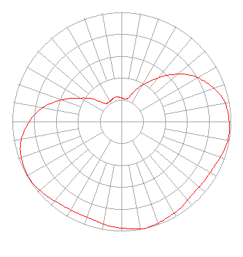 | ||||||||||||||||||
| Azimuth | Ratio | Azimuth | Ratio | Azimuth | Ratio | Azimuth | Ratio | ||||||||||||
| 7 | 0.210 | 17 | 0.230 | 27 | 0.350 | 37 | 0.470 | ||||||||||||
| 47 | 0.630 | 57 | 0.770 | 67 | 0.870 | 77 | 0.950 | ||||||||||||
| 87 | 0.980 | 97 | 0.990 | 107 | 0.970 | 117 | 0.940 | ||||||||||||
| 127 | 0.930 | 137 | 0.930 | 147 | 0.960 | 157 | 0.980 | ||||||||||||
| 167 | 1.000 | 177 | 0.980 | 187 | 0.960 | 197 | 0.930 | ||||||||||||
| 207 | 0.930 | 217 | 0.940 | 227 | 0.970 | 237 | 0.990 | ||||||||||||
| 247 | 0.980 | 257 | 0.950 | 267 | 0.870 | 277 | 0.770 | ||||||||||||
| 287 | 0.630 | 297 | 0.470 | 307 | 0.350 | 317 | 0.230 | ||||||||||||
| 327 | 0.210 | 337 | 0.220 | 347 | 0.230 | 357 | 0.220 | ||||||||||||
Structure Registration Number 1053614 Structure Type: GTOWER Registered To: SpectraSite Communications, LLC. through American Towers, LLC. Structure Address: 95 Poindexter Street (310331) Chesapeake, VA County Name: Chesapeake city ASR Issued: 11/21/2019 Date Built: 11/05/2008 Site Elevation: 2.7 m (9 ft.) Structure Height: 161.8 m (531 ft.) Height Overall: 163 m (535 ft.) Overall Height AMSL: 165.7 m (544 ft.) FAA Determination: 11/20/2019 FAA Study #: 2019-AEA-13343-OE FAA Circular #: 70/7460-1L Paint & Light FAA Chapters: 4, 8, 12 PRIOR STUDY 2010-AEA-1484-OE 36-48-37.4 N 76-16-57.2 W (NAD 83) 36-48-36.9 N 76-16-58.4 W (Converted to NAD 27) |
3901 Highway 121 South Bedford, TX 76021 Phone: 817-571-1229 Private Not-for-Profit Educational Institution | Date: 12/14/2012 Application Certifier WORD OF GOD FELLOWSHIP, INC. 3901 Highway 121 South Bedford, TX 76021 Applicant RICHARD C GOETZ 135 N Country Club Dr Hendersonville, TN 37075 BROADCAST CONSULTANT HENRY TURNER Word Of God Fellowship, Inc. | |||||||||||||||||