
FCCInfo.com
A Service of Cavell, Mertz & Associates, Inc.
(855) FCC-INFO
|
|
KJDA-LD from 03/27/2012 |
|
|
||||||||||||||||
|
|
Status: License (Licensed And Silent) Application Accepted: 04/21/2015 License Expires: 08/01/2022 File Number: -0000001316 FCC Website Links: LMS Facility Details This Application Other KJDA-LD Applications Including Superseded Applications Mailing Address Correspondence for KJDA-LD Correspondence related to application -0000001316 Service Contour - Open Street Map or USGS Map (48 dBu) Service Contour - KML / Google Earth (48 dBu) Rabbit Ears Info Search for KJDA-LD Site Location: 34-01-58.0 N 96-48-01.0 W (NAD 83) Site Location: 34-01-57.6 N 96-47-60.0 W (Converted to NAD 27) ERP: 3 kW Polarization: Horizontally polarized R/C AGL: 400 m (1312 ft.) R/C AMSL: 671.2 m (2202 ft.) Emission Mask: Stringent Site Elevation: 271.2 m. (890 ft.) Height Overall*: 516.3 m (1694 ft.) (* As Filed In This Application, may differ from ASR Data, Below.) Directional Antenna - Antenna Make/Model: Scala CL-713 Antenna ID: 107781 Polarization: Horizontally polarized | ||||||||||||||||||
| Antenna Data for Antenna Id: 107781 KJDA-LD LD File: -0000001316 Scala - CL-713 Service: LD Standard Pattern: Y Pattern and Field Values Include a 180° Clockwise Rotation | 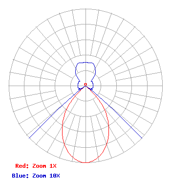 | ||||||||||||||||||
| Azimuth | Ratio | Azimuth | Ratio | Azimuth | Ratio | Azimuth | Ratio | ||||||||||||
| 0 | 0.030 | 10 | 0.030 | 20 | 0.030 | 30 | 0.025 | ||||||||||||
| 40 | 0.020 | 50 | 0.010 | 60 | 0.010 | 70 | 0.010 | ||||||||||||
| 80 | 0.010 | 90 | 0.010 | 100 | 0.010 | 110 | 0.010 | ||||||||||||
| 120 | 0.010 | 130 | 0.030 | 140 | 0.352 | 150 | 0.598 | ||||||||||||
| 160 | 0.805 | 170 | 0.945 | 180 | 1.000 | 190 | 0.945 | ||||||||||||
| 200 | 0.805 | 210 | 0.598 | 220 | 0.352 | 230 | 0.030 | ||||||||||||
| 240 | 0.010 | 250 | 0.010 | 260 | 0.010 | 270 | 0.010 | ||||||||||||
| 280 | 0.010 | 290 | 0.010 | 300 | 0.010 | 310 | 0.010 | ||||||||||||
| 320 | 0.020 | 330 | 0.025 | 340 | 0.030 | 350 | 0.030 | ||||||||||||
Structure Registration Number 1011273 Structure Type: TOWER Registered To: Gray Media Group, Inc. Structure Address: Hwy 99 8.05 Km Ssw Madill, OK County Name: Marshall County ASR Issued: 09/09/2020 Date Built: 02/01/1984 Site Elevation: 271.2 m (890 ft.) Structure Height: 487.6 m (1600 ft.) Height Overall: 516.3 m (1694 ft.) Overall Height AMSL: 787.5 m (2584 ft.) Paint & Light FAA Chapters: A1, B, F, H 34-01-58.0 N 96-48-01.0 W (NAD 83) 34-01-57.6 N 96-47-60.0 W (Converted to NAD 27) |
8330 Lyndon B Johnson Fwy Suite B400 Dallas, TX 75243 Phone: 214-434-5600 Corporation | Title: President Date: 04/21/2015 Application Certifier HISPANIC FAMILY CHRISTIAN NETWORK, INC. Hispanic Family Christian Network, Inc. Po Box 542843 Dallas, TX 75354 Applicant DAN J. Alpert The Law Office Of Dan J. Alpert 2120 N. 21st Rd. Arlington, VA 22201 Antonio C Guel . 2605 Hyacinth Dr Mesquite, TX 75181 consultant | |||||||||||||||||