
FCCInfo.com
A Service of Cavell, Mertz & Associates, Inc.
(855) FCC-INFO
|
|
W24DB-D from 09/15/2015 W24DB-D from 12/17/2004 W24DB-D from 05/03/1995 |
|  |
|
|||||||||||||||
|
|
Repacking Information: No changes Status: License Application Accepted: 09/01/2015 License Expires: 08/01/2023 File Number: -0000004543 FCC Website Links: LMS Facility Details This Application Other W24DB-D Applications Including Superseded Applications Mailing Address Correspondence for W24DB-D Correspondence related to application -0000004543 Service Contour - Open Street Map or USGS Map (51 dBu) Service Contour - KML / Google Earth (51 dBu) Public Inspection Files Rabbit Ears Info Search for W24DB-D Site Location: 41-26-09.1 N 75-43-42.3 W (NAD 83) Site Location: 41-26-08.8 N 75-43-43.6 W (Converted to NAD 27) ERP: 5 kW Polarization: Horizontally polarized Electrical Beam Tilt: 0.5 degrees R/C AGL: 89 m (292 ft.) R/C AMSL: 719.6 m (2361 ft.) Emission Mask: Full Service Site Elevation: 630.6 m. (2069 ft.) Height Overall*: 104.5 m (343 ft.) (* As Filed In This Application, may differ from ASR Data, Below.) Directional Antenna - Antenna Make/Model: Andrew ALP16L2-HSN Antenna ID: 16528 Polarization: Horizontally polarized | ||||||||||||||||||
| Antenna Data for Antenna Id: 16528 W24DB-D DC File: -0000004543 Andrew - ALP16L2-HSN Service: DC Standard Pattern: Y Pattern and Field Values Include a 15° Clockwise Rotation | 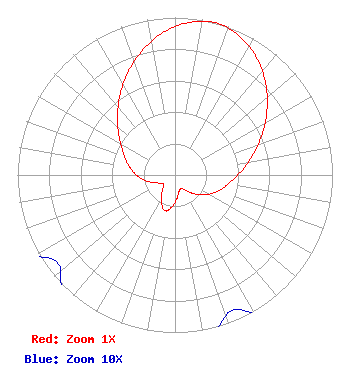 | ||||||||||||||||||
| Azimuth | Ratio | Azimuth | Ratio | Azimuth | Ratio | Azimuth | Ratio | ||||||||||||
| 5 | 0.972 | 15 | 1.000 | 25 | 0.972 | 35 | 0.906 | ||||||||||||
| 45 | 0.815 | 55 | 0.713 | 65 | 0.611 | 75 | 0.517 | ||||||||||||
| 85 | 0.435 | 95 | 0.368 | 105 | 0.316 | 115 | 0.269 | ||||||||||||
| 125 | 0.221 | 135 | 0.168 | 145 | 0.120 | 155 | 0.094 | ||||||||||||
| 165 | 0.104 | 175 | 0.147 | 185 | 0.202 | 195 | 0.236 | ||||||||||||
| 205 | 0.202 | 215 | 0.147 | 225 | 0.104 | 235 | 0.094 | ||||||||||||
| 245 | 0.120 | 255 | 0.168 | 265 | 0.221 | 275 | 0.269 | ||||||||||||
| 285 | 0.316 | 295 | 0.368 | 305 | 0.435 | 315 | 0.517 | ||||||||||||
| 325 | 0.611 | 335 | 0.713 | 345 | 0.815 | 355 | 0.906 | ||||||||||||
Structure Registration Number 1026644 Structure Type: GTOWER Registered To: American Towers LLC Structure Address: W. Mountain Rd. (308464) Scranton, PA County Name: Lackawanna County ASR Issued: 05/23/2017 Date Built: 09/18/2009 Site Elevation: 630.6 m (2069 ft.) Structure Height: 99.4 m (326 ft.) Height Overall: 104.5 m (343 ft.) Overall Height AMSL: 735.1 m (2412 ft.) FAA Determination: 08/05/2009 FAA Study #: 2009-AEA-2200-OE FAA Circular #: 70/7460-1K Paint & Light FAA Chapters: 4, 8, 12 OM&L to remain the same as prior study = A MED-DUAL SYSTEM 41-26-09.1 N 75-43-42.3 W (NAD 83) 41-26-08.8 N 75-43-43.6 W (Converted to NAD 27) |
1181 Highway 315 Wilkes-barre, PA 18702 Phone: 570-970-5600 Limited Liability Company | Title: Chief Executive Officer Date: 09/01/2015 Application Certifier NEW AGE MEDIA OF PENNSYLVANIA LICENSE, LLC New Age Media Of Pennsylvania License, Llc 1181 Highway 315 Wilkes-barre, PA 18702 Applicant Frank R Jazzo, Esq. Fletcher, Heald & Hildreth, Plc 1300 North 17th Street 11th Floor Arlington, VA 22209 FCC Counsel | |||||||||||||||||