
FCCInfo.com
A Service of Cavell, Mertz & Associates, Inc.
(855) FCC-INFO
|
|
WBVJ-CD from 11/04/1998 WBVJ-CD from 03/16/1998 WBVJ-CD from 05/21/1987 WBVJ-CD from 03/13/1987 WBVJ-CD from 12/15/1984 |
|
|
||||||||||||||||
|
|
Repacking Information: No changes Status: License Application Accepted: 09/29/2015 License Expires: 04/01/2021 File Number: -0000004708 FCC Website Links: LMS Facility Details This Application Other WBVJ-CD Applications Including Superseded Applications Mailing Address Correspondence for WBVJ-CD Correspondence related to application -0000004708 Service Contour - Open Street Map or USGS Map (51 dBu) Service Contour - KML / Google Earth (51 dBu) Public Inspection Files Rabbit Ears Info Search for WBVJ-CD Site Location: 30-58-14.0 N 83-17-12.0 W (NAD 83) Site Location: 30-58-13.3 N 83-17-12.4 W (Converted to NAD 27) ERP: 1.5 kW Polarization: Horizontally polarized R/C AGL: 88 m (289 ft.) R/C AMSL: 148.9 m (489 ft.) Emission Mask: Stringent Site Elevation: 60.9 m. (200 ft.) Height Overall*: 91.4 m (300 ft.) (* As Filed In This Application, may differ from ASR Data, Below.) Directional Antenna - Antenna Make/Model: Andrew ALP4L1-HSOC Antenna ID: 16947 Polarization: Horizontally polarized | ||||||||||||||||||
| Antenna Data for Antenna Id: 16947 WBVJ-CD DC File: -0000004708 Andrew - ALP4L1-HSOC Service: DC Standard Pattern: Y | 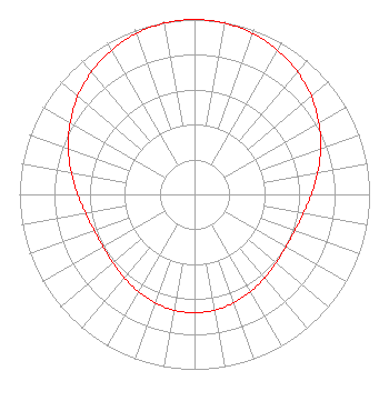 | ||||||||||||||||||
| Azimuth | Ratio | Azimuth | Ratio | Azimuth | Ratio | Azimuth | Ratio | ||||||||||||
| 0 | 1.000 | 10 | 0.994 | 20 | 0.978 | 30 | 0.951 | ||||||||||||
| 40 | 0.915 | 50 | 0.871 | 60 | 0.820 | 70 | 0.767 | ||||||||||||
| 80 | 0.715 | 90 | 0.668 | 100 | 0.631 | 110 | 0.609 | ||||||||||||
| 120 | 0.602 | 130 | 0.608 | 140 | 0.623 | 150 | 0.642 | ||||||||||||
| 160 | 0.659 | 170 | 0.672 | 180 | 0.676 | 190 | 0.672 | ||||||||||||
| 200 | 0.659 | 210 | 0.642 | 220 | 0.623 | 230 | 0.608 | ||||||||||||
| 240 | 0.602 | 250 | 0.609 | 260 | 0.631 | 270 | 0.668 | ||||||||||||
| 280 | 0.715 | 290 | 0.767 | 300 | 0.820 | 310 | 0.871 | ||||||||||||
| 320 | 0.915 | 330 | 0.951 | 340 | 0.978 | 350 | 0.994 | ||||||||||||
Structure Registration Number 1063265 Structure Type: TOWER Registered To: CREASY, JAMES T Structure Address: 5470 Carter Dr Hahira, GA County Name: Lowndes County ASR Issued: 04/15/1999 Date Built: 06/01/1997 Site Elevation: 60.9 m (200 ft.) Structure Height: 91.4 m (300 ft.) Height Overall: 91.4 m (300 ft.) Overall Height AMSL: 152.3 m (500 ft.) FAA Determination: 01/03/1997 FAA Study #: 96-ASO-2832-OE FAA Circular #: 70/7460-1J Paint & Light FAA Chapters: 3, 4, 6, 13 Removed expiration date from determination. Scenario 1./jjs/case#635066 30-58-14.0 N 83-17-12.0 W (NAD 83) 30-58-13.3 N 83-17-12.4 W (Converted to NAD 27) |
1181 Highway 315 Wilkes-barre, PA 18702 Phone: 570-970-5600 Limited Liability Company | Title: Ceo Date: 09/29/2015 Application Certifier NEW AGE MEDIA OF TALLAHASSEE LICENSE, LLC New Age Media Of Tallahassee License, Llc 1181 Highway 315 Wilkes-barre, PA 18702 Applicant Frank R. Jazzo, Esq. Fletcher, Heald & Hildreth, P.l.c. 1300 North 17th Street 11th Floor Arlington, VA 22209 | |||||||||||||||||