
FCCInfo.com
A Service of Cavell, Mertz & Associates, Inc.
(855) FCC-INFO
|
|
|
|
|
||||||||||||||||
|
|
Status: License Application Accepted: 09/07/2016 License Expires: 04/01/2022 File Number: -0000013937 FCC Website Links: LMS Facility Details This Application Other K28MA-D Applications Including Superseded Applications Mailing Address Correspondence for K28MA-D Correspondence related to application -0000013937 Service Contour - Open Street Map or USGS Map (51 dBu) Service Contour - KML / Google Earth (51 dBu) Rabbit Ears Info Search for K28MA-D Site Location: 47-20-32.0 N 97-17-21.0 W (NAD 83) Site Location: 47-20-32.1 N 97-17-19.7 W (Converted to NAD 27) ERP: 15 kW Polarization: Horizontally polarized Electrical Beam Tilt: 1.0 degree R/C AGL: 563.6 m (1849 ft.) R/C AMSL: 860.8 m (2824 ft.) Emission Mask: Stringent Site Elevation: 297.2 m. (975 ft.) Height Overall*: 628.8 m (2063 ft.) (* As Filed In This Application, may differ from ASR Data, Below.) Directional Antenna - Antenna Make/Model: DIELECTRIC TLP-16W Antenna ID: 1001016 Polarization: Horizontally polarized | ||||||||||||||||||
| Antenna Data for Antenna Id: 1001016 K28MA-D LD File: -0000013937 DIELECTRIC - TLP-16W Service: LD Standard Pattern: N Pattern and Field Values Include a 180° Clockwise Rotation | 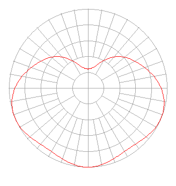 | ||||||||||||||||||
| Azimuth | Ratio | Azimuth | Ratio | Azimuth | Ratio | Azimuth | Ratio | ||||||||||||
| 0 | 0.241 | 10 | 0.253 | 20 | 0.302 | 30 | 0.397 | ||||||||||||
| 40 | 0.510 | 50 | 0.605 | 60 | 0.680 | 70 | 0.758 | ||||||||||||
| 80 | 0.845 | 90 | 0.922 | 100 | 0.975 | 110 | 0.997 | ||||||||||||
| 120 | 0.990 | 130 | 0.959 | 140 | 0.929 | 150 | 0.925 | ||||||||||||
| 160 | 0.951 | 170 | 0.985 | 180 | 1.000 | 190 | 0.985 | ||||||||||||
| 200 | 0.951 | 210 | 0.925 | 220 | 0.929 | 230 | 0.959 | ||||||||||||
| 240 | 0.990 | 250 | 0.997 | 260 | 0.975 | 270 | 0.922 | ||||||||||||
| 280 | 0.845 | 290 | 0.758 | 300 | 0.680 | 310 | 0.605 | ||||||||||||
| 320 | 0.510 | 330 | 0.397 | 340 | 0.302 | 350 | 0.253 | ||||||||||||
Structure Registration Number 1046244 [ASR Heights Differ from K28MA-D Application] Structure Type: GTOWER Registered To: Gray Media Group, Inc. Structure Address: 3 Miles West Blanchard, ND County Name: Traill County ASR Issued: 09/09/2020 Date Built: 08/13/1963 Site Elevation: 297.2 m (975 ft.) Structure Height: 605.6 m (1987 ft.) Height Overall: 605.6 m (1987 ft.) Overall Height AMSL: 902.8 m (2962 ft.) FAA Determination: 10/02/2019 FAA Study #: 2019-AGL-11540-OE FAA Circular #: 70/7460-1L Paint & Light FAA Chapters: 3, 4, 5, 12 PRIOR STUDY 2018-AGL-15816-OE 47-20-32.0 N 97-17-21.0 W (NAD 83) 47-20-32.1 N 97-17-19.7 W (Converted to NAD 27) |
4370 Peachtree Road, Ne Atlanta, GA 30319 Phone: 404-504-9828 Limited Liability Company | Title: Assistant Secretary Date: 09/07/2016 Application Certifier GRAY TELEVISION LICENSEE, LLC Gray Television Licensee, Llc 4370 Peachtree Road, Ne Atlanta, GA 30319 Applicant Joseph M. Davis, P.E. Chesapeake Rf Consultants, Llc 207 Old Dominion Road Yorktown, VA 23692 Consulting Engineer Joan Stewart Wiley Rein Llp 1776 K Street, Nw Washington, DC 20006 | |||||||||||||||||