
FCCInfo.com
A Service of Cavell, Mertz & Associates, Inc.
(855) FCC-INFO
|
|
|
|
|
||||||||||||||||
|
|
Status: License Application Accepted: 09/14/2016 License Expires: 04/01/2022 File Number: -0000014005 FCC Website Links: LMS Facility Details This Application Other K30LR-D Applications Including Superseded Applications Mailing Address Correspondence for K30LR-D Correspondence related to application -0000014005 Service Contour - Open Street Map or USGS Map (51 dBu) Service Contour - KML / Google Earth (51 dBu) Rabbit Ears Info Search for K30LR-D Site Location: 47-57-38.5 N 97-02-35.3 W (NAD 83) Site Location: 47-57-38.6 N 97-02-34.0 W (Converted to NAD 27) ERP: 15 kW Polarization: Elliptically polarized Electrical Beam Tilt: 1 degree R/C AGL: 121.9 m (400 ft.) R/C AMSL: 374.9 m (1230 ft.) Emission Mask: Simple Site Elevation: 253 m. (830 ft.) Height Overall*: 140.2 m (460 ft.) (* As Filed In This Application, may differ from ASR Data, Below.) Directional Antenna - Antenna Make/Model: DIELECTRIC TLP-8M(SP)/VP Antenna ID: 1001025 Polarization: Elliptically polarized | ||||||||||||||||||
| Antenna Data for Antenna Id: 1001025 K30LR-D LD File: -0000014005 DIELECTRIC - TLP-8M(SP)/VP Service: LD Standard Pattern: N | 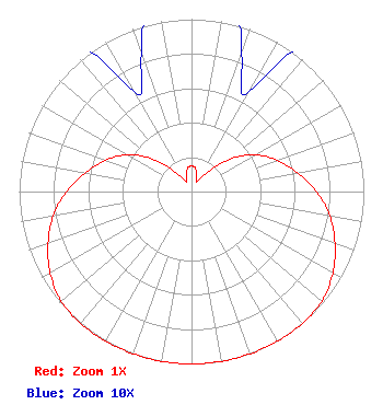 | ||||||||||||||||||
| Azimuth | Ratio | Azimuth | Ratio | Azimuth | Ratio | Azimuth | Ratio | ||||||||||||
| 0 | 0.147 | 10 | 0.136 | 20 | 0.085 | 30 | 0.067 | ||||||||||||
| 40 | 0.146 | 50 | 0.293 | 60 | 0.428 | 70 | 0.529 | ||||||||||||
| 80 | 0.624 | 90 | 0.725 | 100 | 0.815 | 110 | 0.886 | ||||||||||||
| 120 | 0.946 | 130 | 0.988 | 140 | 1.000 | 150 | 1.000 | ||||||||||||
| 160 | 1.000 | 170 | 1.000 | 180 | 1.000 | 190 | 1.000 | ||||||||||||
| 200 | 1.000 | 210 | 1.000 | 220 | 1.000 | 230 | 0.988 | ||||||||||||
| 240 | 0.946 | 250 | 0.886 | 260 | 0.815 | 270 | 0.725 | ||||||||||||
| 280 | 0.624 | 290 | 0.529 | 300 | 0.428 | 310 | 0.293 | ||||||||||||
| 320 | 0.146 | 330 | 0.067 | 340 | 0.085 | 350 | 0.136 | ||||||||||||
Structure Registration Number 1201718 Structure Type: TOWER Registered To: CCATT LLC Structure Address: Sw 1/4 Nw 1/4 Section 27, Township 152 N, Range 50 W East Grand Forks, MN County Name: Polk County ASR Issued: 05/09/2016 Date Built: 06/22/2010 Site Elevation: 253 m (830 ft.) Structure Height: 138.4 m (454 ft.) Height Overall: 140.2 m (460 ft.) Overall Height AMSL: 393.2 m (1290 ft.) FAA Determination: 12/08/2011 FAA Study #: 2011-AGL-7373-OE FAA Circular #: 70/7460-1K Paint & Light FAA Chapters: 4, 8, 12 PRIOR STUDY 1996-AGL-3059-OE 47-57-38.5 N 97-02-35.3 W (NAD 83) 47-57-38.6 N 97-02-34.0 W (Converted to NAD 27) |
4370 Peachtree Road, Ne Atlanta, GA 30319 Phone: 404-504-9828 Limited Liability Company | Title: Assistant Secretary Date: 09/14/2016 Application Certifier GRAY TELEVISION LICENSEE, LLC Gray Television Licensee, Llc 4370 Peachtree Road, Ne Atlanta, GA 30319 Applicant Joseph M. Davis, P.E. Chesapeake Rf Consultants, Llc 207 Old Dominion Road Yorktown, VA 23692 Consulting Engineer Joan Stewart Wiley Rein Llp 1776 K Street, Nw Washington, DC 20006 | |||||||||||||||||