
FCCInfo.com
A Service of Cavell, Mertz & Associates, Inc.
(855) FCC-INFO
|
|
DKHLU-CD from 06/27/2001 DKHLU-CD from 08/26/1994 DKHLU-CD from 04/29/1988 |
Post-repack Channel 36 |
|
||||||||||||||||
|
|
Repacking Information: Pre-Repack Channel: 46 Post-Repack Channel: 36 Post-Repack ERP: 12.3 kW Phase: 2 Completion Deadline: 4/12/2019 Find nearby TV Facilities Status: License Application Accepted: 11/17/2017 License Expires: 02/01/2023 File Number: -0000035482 FCC Website Links: LMS Facility Details This Application Other DKHLU-CD Applications Including Superseded Applications Mailing Address Correspondence for DKHLU-CD Correspondence related to application -0000035482 Service Contour - Open Street Map or USGS Map (51 dBu) Service Contour - KML / Google Earth (51 dBu) Public Inspection Files Rabbit Ears Info Search for DKHLU-CD Site Location: 21-23-33.6 N 158-05-48.1 W (NAD 83) Site Location: 21-23-45.0 N 158-05-58.0 W (Converted to NAD 27) ERP: 15 kW Polarization: Horizontally polarized R/C AGL: 10.1 m (33 ft.) R/C AMSL: 705.2 m (2314 ft.) Emission Mask: Stringent Site Elevation: 695.1 m. (2281 ft.) Height Overall*: 60.6 m (199 ft.) (* As Filed In This Application, may differ from ASR Data, Below.) Directional Antenna - Antenna Make/Model: Antenna Concepts Inc. ACB24D Modified Database#18017 Antenna ID: Polarization: Horizontally polarized | ||||||||||||||||||
| Antenna Data for Antenna Id: DKHLU-CD DC File: -0000035482 Antenna Concepts Inc. - ACB24D Modified Database#18017 Service: DC Standard Pattern: N | 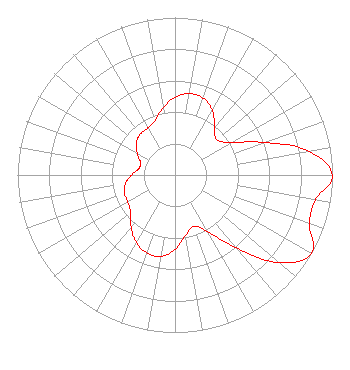 | ||||||||||||||||||
| Azimuth | Ratio | Azimuth | Ratio | Azimuth | Ratio | Azimuth | Ratio | ||||||||||||
| 0 | 0.493 | 10 | 0.525 | 20 | 0.520 | 30 | 0.474 | ||||||||||||
| 40 | 0.390 | 50 | 0.347 | 60 | 0.413 | 70 | 0.605 | ||||||||||||
| 80 | 0.867 | 90 | 1.000 | 100 | 0.907 | 110 | 0.907 | ||||||||||||
| 120 | 1.000 | 130 | 0.867 | 140 | 0.605 | 150 | 0.413 | ||||||||||||
| 160 | 0.347 | 170 | 0.390 | 180 | 0.474 | 190 | 0.525 | ||||||||||||
| 200 | 0.525 | 210 | 0.493 | 220 | 0.434 | 230 | 0.369 | ||||||||||||
| 240 | 0.345 | 250 | 0.341 | 260 | 0.320 | 270 | 0.277 | ||||||||||||
| 280 | 0.233 | 290 | 0.233 | 300 | 0.277 | 310 | 0.320 | ||||||||||||
| 320 | 0.341 | 330 | 0.345 | 340 | 0.369 | 350 | 0.434 | ||||||||||||
Structure Registration Number 1218023 Structure Type: TOWER Registered To: Salem Media of Hawaii Structure Address: Palikea Ridge, 26.9 Km Nw Of Honolulu At 292° True Makakilo, HI County Name: Honolulu County ASR Issued: 10/03/2000 Date Built: 10/03/2000 Site Elevation: 695.1 m (2281 ft.) Structure Height: 60.6 m (199 ft.) Height Overall: 60.6 m (199 ft.) Overall Height AMSL: 755.7 m (2479 ft.) FAA Determination: 09/08/2000 FAA Study #: 00-AWP-2258-OE Paint & Light FAA Chapters: NONE 21-23-33.6 N 158-05-48.1 W (NAD 83) 21-23-45.0 N 158-05-58.0 W (Converted to NAD 27) |
P.o. Box 1239 Kula, HI 96790 Phone: 808-781-8578 Corporation | Title: President Date: 11/17/2017 Application Certifier HTV/HTN/Hawaiian TV Network Ltd. Htv/htn/hawaiian Tv Network, Ltd. P.o. Box 1239 Kula, HI 96790 Applicant Peter Tannenwald Fletcher, Heald & Hildreth, P.l.c. 1300 N. 17th St. 11th Floor Arlington, VA 22209-3801 ATTORNEY | |||||||||||||||||