
FCCInfo.com
A Service of Cavell, Mertz & Associates, Inc.
(855) FCC-INFO
|
|
KMYU from 09/11/1989 |
Virtual Channel 12 |  |
|
||||||||||||||||||||||||||||||||||||
|
|
Repacking Information: No changes Status: Construction Permit Application Accepted: 11/28/2017 KMYU CP Expires: 11/12/2023 File Number: -0000035745 FCC Website Links: LMS Facility Details This Application Other KMYU Applications Including Superseded Applications Mailing Address Correspondence for KMYU Correspondence related to application -0000035745 Service Contour - Open Street Map or USGS Map (36 dBu) Service Contour - KML / Google Earth (36 dBu) Public Inspection Files Rabbit Ears Info Search for KMYU Site Location: 37-03-48.0 N 113-34-26.0 W (NAD 83) Site Location: 37-03-48.1 N 113-34-23.2 W (Converted to NAD 27) ERP: 160 kW Polarization: Horizontally polarized HAAT: 57 m (187 ft.) R/C AGL: 7 m (23 ft.) R/C AMSL: 964.6 m (3165 ft.) Site Elevation: 957.6 m. (3142 ft.) Height Overall*: 28.9 m (95 ft.) (* As Filed In This Application, may differ from ASR Data, Below.) Directional Antenna - Antenna Make/Model: DIELECTRIC THP-C1-4-1R Antenna ID: 44874 Polarization: Horizontally polarized
| |||||||||||||||||||||||||||||||||||||||
| Antenna Data for Antenna Id: 44874 KMYU DT File: -0000035745 DIELECTRIC - THP-C1-4-1R Service: DT Standard Pattern: Y Pattern and Field Values Include a 50° Clockwise Rotation | 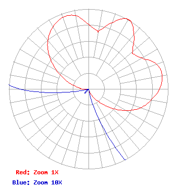 | |||||||||||||||||||||||||||||||||||||||
| Azimuth | Ratio | Azimuth | Ratio | Azimuth | Ratio | Azimuth | Ratio | |||||||||||||||||||||||||||||||||
| 0 | 0.807 | 9 | 0.734 | 10 | 0.736 | 20 | 0.883 | |||||||||||||||||||||||||||||||||
| 28 | 0.994 | 30 | 1.000 | 32 | 0.997 | 40 | 0.886 | |||||||||||||||||||||||||||||||||
| 50 | 0.726 | 53 | 0.719 | 60 | 0.775 | 70 | 0.908 | |||||||||||||||||||||||||||||||||
| 80 | 0.939 | 90 | 0.893 | 100 | 0.800 | 110 | 0.694 | |||||||||||||||||||||||||||||||||
| 120 | 0.539 | 130 | 0.371 | 140 | 0.216 | 150 | 0.124 | |||||||||||||||||||||||||||||||||
| 160 | 0.046 | 170 | 0.001 | 180 | 0.001 | 190 | 0.001 | |||||||||||||||||||||||||||||||||
| 200 | 0.001 | 210 | 0.001 | 220 | 0.007 | 230 | 0.004 | |||||||||||||||||||||||||||||||||
| 240 | 0.001 | 250 | 0.001 | 260 | 0.021 | 270 | 0.086 | |||||||||||||||||||||||||||||||||
| 280 | 0.145 | 290 | 0.295 | 300 | 0.462 | 310 | 0.645 | |||||||||||||||||||||||||||||||||
| 320 | 0.794 | 330 | 0.893 | 340 | 0.950 | 350 | 0.929 | |||||||||||||||||||||||||||||||||
Structure Registration Number 1053312 [ASR Heights Differ from KMYU Application] Structure Type: LTOWER Registered To: American Towers LLC Structure Address: Webb Hill - Washington County (#209530) St. George, UT County Name: Washington County ASR Issued: 03/21/2022 Date Built: 04/23/1999 Site Elevation: 951.9 m (3123 ft.) Structure Height: 27.4 m (90 ft.) Height Overall: 28.9 m (95 ft.) Overall Height AMSL: 980.8 m (3218 ft.) FAA Determination: 02/18/2022 FAA Study #: 2022-ANM-1248-OE Paint & Light FAA Chapters: NONE PRIOR STUDY 2021-ANM-4683-OE 37-03-49.3 N 113-34-25.7 W (NAD 83) 37-03-49.4 N 113-34-22.9 W (Converted to NAD 27) |
1200 Seventeenth Street, Nw Washington, Dc, MD 21030 Phone: 212-663-8195 Limited Liability Company | Title: Vice President Of Engineering Date: 11/28/2017 Application Certifier KUTV LICENSEE, LLC Kutv Licensee, Llc 10706 Beaver Dam Road Cockeysville, MD 21030 Applicant John E. Hidle, PE Carl T. Jones Corporation 7901 Yarnwood Court Springfield, VA 22153-2827 Consulting Engineer Paul A. Cicelski, Esq Lerman Senter Pllc 2001 L St Nw Suite 400 Washington, DC 20036 | ||||||||||||||||||||||||||||||||||||||