
FCCInfo.com
A Service of Cavell, Mertz & Associates, Inc.
(855) FCC-INFO
|
|
|
|
|
||||||||||||||||
|
|
Status: Construction Permit (Licensed And Silent) Application Accepted: 11/28/2017 K49LJ-D CP Expires: 09/06/2022 File Number: -0000035784 FCC Website Links: LMS Facility Details This Application Other K49LJ-D Applications Including Superseded Applications Mailing Address Correspondence for K49LJ-D Correspondence related to application -0000035784 Service Contour - Open Street Map or USGS Map (51 dBu) Service Contour - KML / Google Earth (51 dBu) Rabbit Ears Info Search for K49LJ-D Site Location: 42-44-37.0 N 106-18-33.0 W (NAD 83) Site Location: 42-44-37.1 N 106-18-30.9 W (Converted to NAD 27) ERP: 5 kW Polarization: Horizontally polarized Electrical Beam Tilt: 0.5 degrees R/C AGL: 73 m (240 ft.) R/C AMSL: 2513 m (8245 ft.) Emission Mask: Stringent Site Elevation: 2440 m. (8005 ft.) Height Overall*: 103.6 m (340 ft.) (* As Filed In This Application, may differ from ASR Data, Below.) Directional Antenna - Antenna Make/Model: MICRO COMMUNICATIONS INC 955512 Antenna ID: 20067 Polarization: Horizontally polarized | ||||||||||||||||||
| Antenna Data for Antenna Id: 20067 K49LJ-D LD File: -0000035784 MICRO COMMUNICATIONS INC - 955512 Service: LD Standard Pattern: Y Pattern and Field Values Include a 345° Clockwise Rotation | 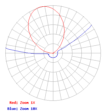 | ||||||||||||||||||
| Azimuth | Ratio | Azimuth | Ratio | Azimuth | Ratio | Azimuth | Ratio | ||||||||||||
| 5 | 0.872 | 15 | 0.729 | 25 | 0.556 | 35 | 0.378 | ||||||||||||
| 45 | 0.218 | 55 | 0.094 | 65 | 0.021 | 75 | 0.010 | ||||||||||||
| 85 | 0.010 | 95 | 0.010 | 105 | 0.010 | 115 | 0.010 | ||||||||||||
| 125 | 0.010 | 135 | 0.010 | 145 | 0.010 | 155 | 0.010 | ||||||||||||
| 165 | 0.010 | 175 | 0.010 | 185 | 0.010 | 195 | 0.010 | ||||||||||||
| 205 | 0.010 | 215 | 0.010 | 225 | 0.010 | 235 | 0.010 | ||||||||||||
| 245 | 0.010 | 255 | 0.010 | 265 | 0.021 | 275 | 0.094 | ||||||||||||
| 285 | 0.218 | 295 | 0.378 | 305 | 0.556 | 315 | 0.729 | ||||||||||||
| 325 | 0.872 | 335 | 0.967 | 345 | 1.000 | 355 | 0.967 | ||||||||||||
Structure Registration Number 1001086 Structure Type: TOWER Registered To: Mt. Rushmore Broadcasting, Inc. Structure Address: 8500 Casper Mountain Rd Casper, WY County Name: Natrona County ASR Issued: 11/01/2022 Date Built: 09/13/1995 Site Elevation: 2440 m (8005 ft.) Structure Height: 98 m (322 ft.) Height Overall: 103.6 m (340 ft.) Overall Height AMSL: 2543.6 m (8345 ft.) FAA Determination: 08/12/1994 FAA Study #: 94-ANM-0555-OE FAA Circular #: 70/7460-1H Paint & Light FAA Chapters: 3, 4, 5, 13 42-44-37.0 N 106-18-33.0 W (NAD 83) 42-44-37.1 N 106-18-30.9 W (Converted to NAD 27) |
Hurst, TX 76054 Phone: 214-770-7770 Corporation | Title: Ceo Date: 11/28/2017 Application Certifier THE EDGE SPECTRUM, INC. The Edge Spectrum, Inc. 7829 Center Blvd. Se No. 190 Snoqualmie, WA 98065 Applicant Randy Weiss Edge Spectrum, Inc. Po Box 54025 Hurst, TX 76054 President Byron W. St. Clair B. W. St. Clair 2355 Ranch Drive Westminster, CO 80234 Engineering Consultant | |||||||||||||||||