
FCCInfo.com
A Service of Cavell, Mertz & Associates, Inc.
(855) FCC-INFO
|
|
WGWW from 05/28/1984 WGWW from 01/23/1979 |
Virtual Channel 40 |
|
||||||||||||||||
|
|
Repacking Information: No changes Status: Construction Permit Application Accepted: 12/05/2017 WGWW CP Expires: 11/20/2023 File Number: -0000036011 FCC Website Links: LMS Facility Details This Application Other WGWW Applications Including Superseded Applications Mailing Address Correspondence for WGWW Correspondence related to application -0000036011 Service Contour - Open Street Map or USGS Map (36 dBu) Service Contour - KML / Google Earth (36 dBu) Public Inspection Files History Cards for WGWW Rabbit Ears Info Search for WGWW Site Location: 33-36-24.0 N 86-25-03.0 W (NAD 83) Site Location: 33-36-23.6 N 86-25-03.1 W (Converted to NAD 27) ERP: 19.1 kW Polarization: Horizontally polarized HAAT: 396 m (1299 ft.) Electrical Beam Tilt: 1.5 degrees R/C AGL: 162.9 m (534 ft.) R/C AMSL: 614 m (2014 ft.) Site Elevation: 451.1 m. (1480 ft.) Height Overall*: 172.5 m (566 ft.) (* As Filed In This Application, may differ from ASR Data, Below.) Directional Antenna - Antenna Make/Model: DIELECTRIC THV-6A9-R S190 Antenna ID: 66854 Polarization: Horizontally polarized | ||||||||||||||||||
| Antenna Data for Antenna Id: 66854 WGWW DT File: -0000036011 DIELECTRIC - THV-6A9-R S190 Service: DT Standard Pattern: Y | 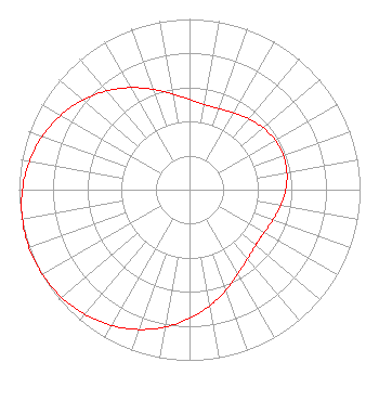 | ||||||||||||||||||
| Azimuth | Ratio | Azimuth | Ratio | Azimuth | Ratio | Azimuth | Ratio | ||||||||||||
| 0 | 0.528 | 10 | 0.506 | 16 | 0.503 | 20 | 0.505 | ||||||||||||
| 30 | 0.519 | 40 | 0.542 | 50 | 0.564 | 60 | 0.580 | ||||||||||||
| 70 | 0.586 | 80 | 0.580 | 90 | 0.564 | 100 | 0.542 | ||||||||||||
| 110 | 0.519 | 120 | 0.505 | 124 | 0.503 | 130 | 0.506 | ||||||||||||
| 140 | 0.528 | 150 | 0.569 | 160 | 0.626 | 170 | 0.690 | ||||||||||||
| 180 | 0.755 | 190 | 0.817 | 200 | 0.872 | 210 | 0.918 | ||||||||||||
| 220 | 0.954 | 230 | 0.980 | 240 | 0.995 | 250 | 1.000 | ||||||||||||
| 260 | 0.995 | 270 | 0.980 | 280 | 0.954 | 290 | 0.918 | ||||||||||||
| 300 | 0.872 | 310 | 0.817 | 320 | 0.755 | 330 | 0.690 | ||||||||||||
| 340 | 0.626 | 350 | 0.569 | ||||||||||||||||
Structure Registration Number 1033525 Structure Type: TOWER Registered To: TV Alabama, Incorporated Structure Address: 3415 Bald Rock Rd Bald Rock Mountain Leeds, AL County Name: St. Clair County ASR Issued: 01/11/2017 Date Built: 09/12/1997 Site Elevation: 451.1 m (1480 ft.) Structure Height: 153 m (502 ft.) Height Overall: 172.5 m (566 ft.) Overall Height AMSL: 623.6 m (2046 ft.) FAA Determination: 12/10/1997 FAA Study #: 95-ASO-2145-OE FAA Circular #: 70/7460-1J Paint & Light FAA Chapters: 4, 7, 13 33-36-24.0 N 86-25-03.0 W (NAD 83) 33-36-23.6 N 86-25-03.1 W (Converted to NAD 27) |
201 Massachusetts Avenue, Ne Suite C-1 Washington, DC 20002 Phone: 202-546-5400 Limited Liability Company | Title: Managing Member Date: 12/05/2017 Application Certifier HSH BIRMINGHAM (WCFT) LICENSEE, LLC Hsh Birmingham (wcft) Licensee, Llc 201 Massachusetts Avenue, Ne Suite C-1 Washington, DC 20002 Applicant Paul A. Cicelski, Esq Lerman Senter Pllc 2001 L St Nw Suite 400 Washington, DC 20036 John E. Hidle, PE Carl T. Jones Corporation 7901 Yarnwood Court Springfield, VA 22153-2827 Consulting Engineer Colby M. May, Esq Colby M. May, Esq., P.c. Washington, DC 20003 Attorney | |||||||||||||||||