
FCCInfo.com
A Service of Cavell, Mertz & Associates, Inc.
(855) FCC-INFO
|
|
DW50EG-D from 12/13/2010 |
|
|
||||||||||||||||
|
|
Status: License Application Accepted: 12/07/2017 License Expires: 02/01/2021 File Number: -0000036099 FCC Website Links: LMS Facility Details This Application Other DW50EG-D Applications Including Superseded Applications Mailing Address Correspondence for DW50EG-D Correspondence related to application -0000036099 Service Contour - Open Street Map or USGS Map (51 dBu) Service Contour - KML / Google Earth (51 dBu) Rabbit Ears Info Search for DW50EG-D Site Location: 18-21-20.8 N 64-56-51.5 W (NAD 83) Site Location: 18-21-28.0 N 64-56-53.0 W (Converted to NAD 27) ERP: 15 kW Polarization: Horizontally polarized Electrical Beam Tilt: 0.5 degrees R/C AGL: 69 m (226 ft.) R/C AMSL: 514.7 m (1689 ft.) Emission Mask: Stringent Site Elevation: 445.7 m. (1462 ft.) Height Overall*: 78 m (256 ft.) (* As Filed In This Application, may differ from ASR Data, Below.) Directional Antenna - Antenna Make/Model: Antenna Concepts Inc. ACS8A Antenna ID: 17788 Polarization: Horizontally polarized | ||||||||||||||||||
| Antenna Data for Antenna Id: 17788 DW50EG-D LD File: -0000036099 Antenna Concepts Inc. - ACS8A Service: LD Standard Pattern: Y Pattern and Field Values Include a 30° Clockwise Rotation | 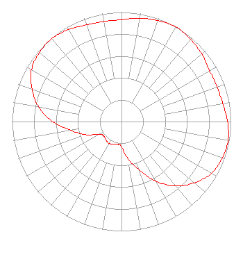 | ||||||||||||||||||
| Azimuth | Ratio | Azimuth | Ratio | Azimuth | Ratio | Azimuth | Ratio | ||||||||||||
| 0 | 0.930 | 10 | 0.960 | 20 | 0.980 | 30 | 1.000 | ||||||||||||
| 40 | 0.980 | 50 | 0.960 | 60 | 0.930 | 70 | 0.930 | ||||||||||||
| 80 | 0.940 | 90 | 0.970 | 100 | 0.990 | 110 | 0.980 | ||||||||||||
| 120 | 0.950 | 130 | 0.870 | 140 | 0.770 | 150 | 0.630 | ||||||||||||
| 160 | 0.470 | 170 | 0.350 | 180 | 0.230 | 190 | 0.210 | ||||||||||||
| 200 | 0.220 | 210 | 0.230 | 220 | 0.220 | 230 | 0.210 | ||||||||||||
| 240 | 0.230 | 250 | 0.350 | 260 | 0.470 | 270 | 0.630 | ||||||||||||
| 280 | 0.770 | 290 | 0.870 | 300 | 0.950 | 310 | 0.980 | ||||||||||||
| 320 | 0.990 | 330 | 0.970 | 340 | 0.940 | 350 | 0.930 | ||||||||||||
Structure Registration Number 1244135 Structure Type: TOWER Registered To: Virgin Islands Public Television System Structure Address: Atop Signal Hill, 1.3 Miles North Of Charlotte Amalie, St. Thomas, Virgin Island St. Thomas, VI County Name: St. Thomas Island ASR Issued: 07/01/2004 Date Built: 02/06/2006 Site Elevation: 445.7 m (1462 ft.) Structure Height: 78 m (256 ft.) Height Overall: 78 m (256 ft.) Overall Height AMSL: 523.7 m (1718 ft.) FAA Determination: 01/08/2004 FAA Study #: 2003-ASO-6388-OE FAA Circular #: 70/7460-1K Paint & Light FAA Chapters: 4, 8, 12 18-21-20.8 N 64-56-51.5 W (NAD 83) 18-21-28.0 N 64-56-53.0 W (Converted to NAD 27) |
Po Box 903 Saint Just, PR 00978 Phone: 787-761-2833 Corporation | Title: President Date: 12/07/2017 Application Certifier TV RED DE PUERTO RICO INC Tv Red De Puerto Rico Inc Po Box 903 Saint Just, PR 00978 Applicant JORGE R FIGUEROA Tv Red De Puerto Rico Inc Po Box 903 Saint Just, PR 00978 PRESIDENT GRAFTON OLIVERA Grafton Olivera Consulting Engineer 5119 60th Drive E Bradenton, FL 34203 TECHNICAL CONSULTANT | |||||||||||||||||