
FCCInfo.com
A Service of Cavell, Mertz & Associates, Inc.
(855) FCC-INFO
|
|
DKBLM-LP from 09/01/1999 DKBLM-LP from 05/07/1999 |
|
|
||||||||||||||||
|
|
Status: License Application Accepted: 06/01/2018 License Expires: 12/01/2014 File Number: -0000054930 FCC Website Links: LMS Facility Details This Application Other DKBLM-LP Applications Including Superseded Applications Mailing Address Correspondence for DKBLM-LP Correspondence related to application -0000054930 Service Contour - Open Street Map or USGS Map (74 dBu) Service Contour - KML / Google Earth (74 dBu) Rabbit Ears Info Search for DKBLM-LP Site Location: 33-57-44.0 N 117-16-51.0 W (NAD 83) Site Location: 33-57-43.9 N 117-16-47.9 W (Converted to NAD 27) ERP: 9.55 kW R/C AGL: 15.2 m (50 ft.) R/C AMSL: 950.2 m (3117 ft.) Site Elevation: 935 m. (3068 ft.) Height Overall*: 36.6 m (120 ft.) (* As Filed In This Application, may differ from ASR Data, Below.) Directional Antenna - Antenna Make/Model: Bogner B8UB (2) Antenna ID: 58932 | ||||||||||||||||||
| Antenna Data for Antenna Id: 58932 DKBLM-LP TX File: -0000054930 Bogner - B8UB (2) Service: TX Standard Pattern: Y | 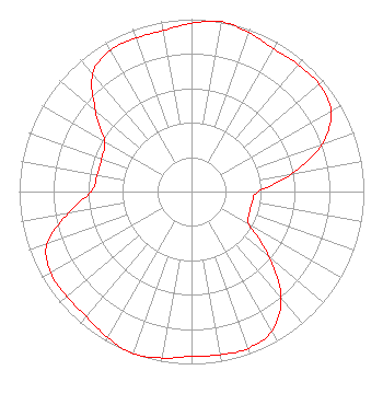 | ||||||||||||||||||
| Azimuth | Ratio | Azimuth | Ratio | Azimuth | Ratio | Azimuth | Ratio | ||||||||||||
| 0 | 0.977 | 10 | 1.000 | 20 | 0.980 | 30 | 0.956 | ||||||||||||
| 40 | 0.961 | 50 | 0.967 | 60 | 0.934 | 70 | 0.807 | ||||||||||||
| 80 | 0.587 | 90 | 0.387 | 100 | 0.358 | 110 | 0.358 | ||||||||||||
| 120 | 0.387 | 130 | 0.587 | 140 | 0.807 | 150 | 0.934 | ||||||||||||
| 160 | 0.967 | 170 | 0.961 | 180 | 0.956 | 190 | 0.980 | ||||||||||||
| 200 | 1.000 | 210 | 0.977 | 220 | 0.948 | 230 | 0.946 | ||||||||||||
| 240 | 0.944 | 250 | 0.892 | 260 | 0.728 | 270 | 0.583 | ||||||||||||
| 280 | 0.556 | 290 | 0.556 | 300 | 0.583 | 310 | 0.728 | ||||||||||||
| 320 | 0.892 | 330 | 0.944 | 340 | 0.946 | 350 | 0.948 | ||||||||||||
Structure Registration Number 1012220 Structure Type: TOWER Registered To: Riverside, County of Structure Address: Box Springs Mountain Riverside, CA County Name: Riverside County ASR Issued: 03/04/2005 Date Built: 04/30/1990 Site Elevation: 935 m (3068 ft.) Structure Height: 30 m (98 ft.) Height Overall: 36.6 m (120 ft.) Overall Height AMSL: 971.6 m (3188 ft.) FAA Determination: 04/04/1990 FAA Study #: 90-AWP-167-OE Paint & Light FAA Chapters: NONE 33-57-44.0 N 117-16-51.0 W (NAD 83) 33-57-43.9 N 117-16-47.9 W (Converted to NAD 27) |
5220 Campo Road Woodland Hills, CA 91364 Phone: 818-652-4194 Limited Liability Company | Title: Member/manager Date: 06/01/2018 Application Certifier Sky Blue Broadcasting, Llc 5220 Campo Road Woodland Hills, CA 91364 Applicant Susan Hansen B. W. St. Clair 2355 Ranch Drive Westminster, CO 80234 | |||||||||||||||||