
FCCInfo.com
A Service of Cavell, Mertz & Associates, Inc.
(855) FCC-INFO
|
|
W34FC-D from 10/27/2009 W34FC-D from 01/24/1990 |
|
|
||||||||||||||||
|
|
Status: License Application Accepted: 08/14/2018 License Expires: 12/01/2021 File Number: -0000058890 FCC Website Links: LMS Facility Details This Application Other W34FC-D Applications Including Superseded Applications Mailing Address Correspondence for W34FC-D Correspondence related to application -0000058890 Service Contour - Open Street Map or USGS Map (51 dBu) Service Contour - KML / Google Earth (51 dBu) Rabbit Ears Info Search for W34FC-D Site Location: 43-48-23.0 N 91-22-03.0 W (NAD 83) Site Location: 43-48-23.1 N 91-22-02.5 W (Converted to NAD 27) ERP: 15 kW Polarization: Horizontally polarized Electrical Beam Tilt: 1.05 degrees R/C AGL: 229.4 m (753 ft.) R/C AMSL: 603 m (1978 ft.) Emission Mask: Full Service Site Elevation: 373.6 m. (1226 ft.) Height Overall*: 249.7 m (819 ft.) (* As Filed In This Application, may differ from ASR Data, Below.) Directional Antenna - Antenna Make/Model: DIELECTRIC TFU-8WB-C160 Antenna ID: 1004018 Polarization: Horizontally polarized
| ||||||||||||||||||
| Antenna Data for Antenna Id: 1004018 W34FC-D LD File: -0000058890 DIELECTRIC - TFU-8WB-C160 Service: LD Standard Pattern: N Pattern and Field Values Include a 70° Clockwise Rotation | 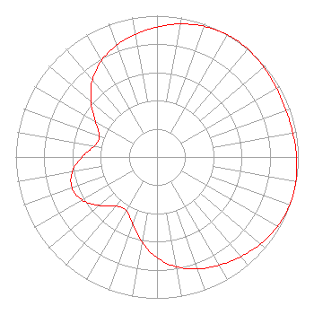 | ||||||||||||||||||
| Azimuth | Ratio | Azimuth | Ratio | Azimuth | Ratio | Azimuth | Ratio | ||||||||||||
| 0 | 0.920 | 10 | 0.956 | 20 | 0.984 | 30 | 0.998 | ||||||||||||
| 35 | 1.000 | 40 | 0.998 | 50 | 0.987 | 60 | 0.976 | ||||||||||||
| 70 | 0.971 | 80 | 0.976 | 90 | 0.988 | 100 | 0.998 | ||||||||||||
| 105 | 1.000 | 110 | 0.998 | 120 | 0.984 | 130 | 0.956 | ||||||||||||
| 140 | 0.921 | 150 | 0.883 | 160 | 0.842 | 170 | 0.788 | ||||||||||||
| 180 | 0.713 | 190 | 0.612 | 200 | 0.504 | 210 | 0.435 | ||||||||||||
| 220 | 0.452 | 230 | 0.533 | 240 | 0.610 | 250 | 0.640 | ||||||||||||
| 260 | 0.609 | 270 | 0.531 | 280 | 0.450 | 290 | 0.433 | ||||||||||||
| 300 | 0.503 | 310 | 0.611 | 320 | 0.711 | 330 | 0.786 | ||||||||||||
| 340 | 0.840 | 350 | 0.882 | ||||||||||||||||
Structure Registration Number 1035149 Structure Type: TOWER Registered To: La Crosse TV License Company, LLC Structure Address: 3705 Cth 25 La Crescent, MN County Name: Houston County ASR Issued: 08/19/2021 Date Built: 10/23/1982 Site Elevation: 373.6 m (1226 ft.) Structure Height: 232.7 m (763 ft.) Height Overall: 249.7 m (819 ft.) Overall Height AMSL: 623.3 m (2045 ft.) FAA Determination: 04/14/1983 FAA Study #: 82-AGL-53-OE FAA Circular #: 70/7460-1F Paint & Light FAA Chapters: 4, 6, 9 43-48-23.0 N 91-22-03.0 W (NAD 83) 43-48-23.1 N 91-22-02.5 W (Converted to NAD 27) |
4370 Peachtree Road, Ne Atlanta, GA 30319 Phone: 404-504-9828 Limited Liability Company | Title: President Date: 08/14/2018 Application Certifier KTTC License, LLC Kttc License, Llc P.o. Box 909 Quincy, IL 62306 Applicant Stephen Hartzell Brooks, Pierce Et Al. 150 Fayetteville Street Suite 1700 Raleigh, NC 27601 Scott Turpie Lohnes & Culver Llc Silver Spring, MD 20918 | |||||||||||||||||