
FCCInfo.com
A Service of Cavell, Mertz & Associates, Inc.
(855) FCC-INFO
|
|
K17NF-D from 12/08/2016 K17NF-D from 11/25/2002 K17NF-D from 07/15/1999 K17NF-D from 07/16/1999 K17NF-D from 12/04/1998 |
|
|
||||||||||||||||
|
|
Status: License Application Accepted: 08/22/2018 License Expires: 04/01/2022 File Number: -0000059096 FCC Website Links: LMS Facility Details This Application Other K17NF-D Applications Including Superseded Applications Mailing Address Correspondence for K17NF-D Correspondence related to application -0000059096 Service Contour - Open Street Map or USGS Map (51 dBu) Service Contour - KML / Google Earth (51 dBu) Rabbit Ears Info Search for K17NF-D Site Location: 44-20-22.0 N 96-46-08.0 W (NAD 83) Site Location: 44-20-22.1 N 96-46-06.8 W (Converted to NAD 27) ERP: 7.01 kW Polarization: Horizontally polarized Electrical Beam Tilt: 0.5 degrees R/C AGL: 103 m (338 ft.) R/C AMSL: 596.5 m (1957 ft.) Emission Mask: Simple Site Elevation: 493.5 m. (1619 ft.) Height Overall*: 106.8 m (350 ft.) (* As Filed In This Application, may differ from ASR Data, Below.) Directional Antenna - Antenna Make/Model: Andrew ALP12L2-HSOC Antenna ID: 16389 Polarization: Horizontally polarized
| ||||||||||||||||||
| Antenna Data for Antenna Id: 16389 K17NF-D LD File: -0000059096 Andrew - ALP12L2-HSOC Service: LD Standard Pattern: Y Pattern and Field Values Include a 185° Clockwise Rotation | 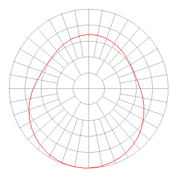 | ||||||||||||||||||
| Azimuth | Ratio | Azimuth | Ratio | Azimuth | Ratio | Azimuth | Ratio | ||||||||||||
| 5 | 0.676 | 15 | 0.672 | 25 | 0.659 | 35 | 0.642 | ||||||||||||
| 45 | 0.623 | 55 | 0.608 | 65 | 0.602 | 75 | 0.609 | ||||||||||||
| 85 | 0.631 | 95 | 0.668 | 105 | 0.715 | 115 | 0.767 | ||||||||||||
| 125 | 0.820 | 135 | 0.871 | 145 | 0.915 | 155 | 0.951 | ||||||||||||
| 165 | 0.978 | 175 | 0.994 | 185 | 1.000 | 195 | 0.994 | ||||||||||||
| 205 | 0.978 | 215 | 0.951 | 225 | 0.915 | 235 | 0.871 | ||||||||||||
| 245 | 0.820 | 255 | 0.767 | 265 | 0.715 | 275 | 0.668 | ||||||||||||
| 285 | 0.631 | 295 | 0.609 | 305 | 0.602 | 315 | 0.608 | ||||||||||||
| 325 | 0.623 | 335 | 0.642 | 345 | 0.659 | 355 | 0.672 | ||||||||||||
Structure Registration Number 1042108 Structure Type: TOWER Registered To: Gray Media Group, Inc. Structure Address: 1.5 Km Nw Of Jct By-pass Rt 14 & Sr 29/77 Brookings, SD County Name: Brookings County ASR Issued: 10/02/2019 Date Built: 02/10/1997 Site Elevation: 493.5 m (1619 ft.) Structure Height: 106 m (348 ft.) Height Overall: 106.8 m (350 ft.) Overall Height AMSL: 600.2 m (1969 ft.) FAA Determination: 03/13/1998 FAA Study #: 97-AGL-5816-OE FAA Circular #: 70/7460-1J Paint & Light FAA Chapters: 4, 8, 13 REPLACES 96-AGL-0530-OE. 44-20-22.0 N 96-46-08.0 W (NAD 83) 44-20-22.1 N 96-46-06.8 W (Converted to NAD 27) |
4370 Peachtree Road, Ne Atlanta, GA 30319 Phone: 404-504-9828 Limited Liability Company | Title: Chief Operating Officer Date: 08/22/2018 Application Certifier RED RIVER BROADCAST CO., LLC Red River Broadcast Co., Llc P.o. Box 9115 Fargo, ND 58106 Applicant CHARLES R. NAFTALIN, ESQ Holland & Knight Llp 800 17th Street Nw, Suite 1100 Washington, DC 20006 FCC LEGAL COUNSEL | |||||||||||||||||