
FCCInfo.com
A Service of Cavell, Mertz & Associates, Inc.
(855) FCC-INFO
|
|
KRTX-LD from 10/23/2018 KRTX-LD from 04/01/2013 KRTX-LD from 11/30/1987 |
|
|
||||||||||||||||
|
|
Status: License Application Accepted: 10/22/2018 License Expires: 08/01/2022 File Number: -0000063010 FCC Website Links: LMS Facility Details This Application Other KRTX-LD Applications Including Superseded Applications Mailing Address Correspondence for KRTX-LD Correspondence related to application -0000063010 Service Contour - Open Street Map or USGS Map (51 dBu) Service Contour - KML / Google Earth (51 dBu) Rabbit Ears Info Search for KRTX-LD Site Location: 29-27-34.9 N 98-24-25.5 W (NAD 83) Site Location: 29-27-34.1 N 98-24-24.4 W (Converted to NAD 27) ERP: 10 kW Polarization: Horizontally polarized Electrical Beam Tilt: 1.00 degree R/C AGL: 89.1 m (292 ft.) R/C AMSL: 300 m (984 ft.) Emission Mask: Full Service Site Elevation: 210.9 m. (692 ft.) Height Overall*: 106.6 m (350 ft.) (* As Filed In This Application, may differ from ASR Data, Below.) Directional Antenna - Antenna Make/Model: Propagation System Inc PSILP08AMR Antenna ID: 1004248 Polarization: Horizontally polarized | ||||||||||||||||||
| Antenna Data for Antenna Id: 1004248 KRTX-LD LD File: -0000063010 Propagation System Inc - PSILP08AMR Service: LD Standard Pattern: N Pattern and Field Values Include a 250° Clockwise Rotation | 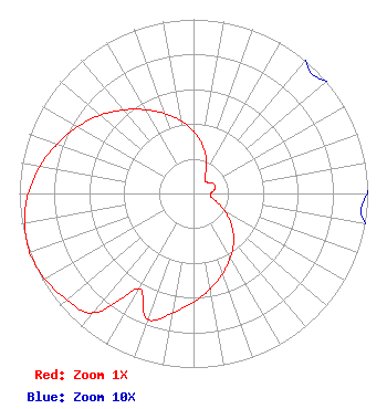 | ||||||||||||||||||
| Azimuth | Ratio | Azimuth | Ratio | Azimuth | Ratio | Azimuth | Ratio | ||||||||||||
| 0 | 0.358 | 10 | 0.287 | 20 | 0.212 | 30 | 0.141 | ||||||||||||
| 40 | 0.101 | 50 | 0.100 | 60 | 0.122 | 70 | 0.132 | ||||||||||||
| 80 | 0.122 | 90 | 0.100 | 100 | 0.101 | 110 | 0.141 | ||||||||||||
| 120 | 0.212 | 130 | 0.287 | 140 | 0.358 | 150 | 0.425 | ||||||||||||
| 160 | 0.490 | 170 | 0.556 | 180 | 0.626 | 190 | 0.698 | ||||||||||||
| 200 | 0.767 | 210 | 0.632 | 220 | 0.895 | 230 | 0.949 | ||||||||||||
| 240 | 0.985 | 250 | 1.000 | 260 | 0.985 | 270 | 0.949 | ||||||||||||
| 280 | 0.895 | 290 | 0.832 | 300 | 0.767 | 310 | 0.698 | ||||||||||||
| 320 | 0.626 | 330 | 0.556 | 340 | 0.490 | 350 | 0.425 | ||||||||||||
Structure Registration Number 1220126 [ASR Heights Differ from KRTX-LD Application] Structure Type: GTOWER Registered To: American Towers LLC Structure Address: 510 Petroleum Dr. (374550) San Antonio, TX County Name: Bexar County ASR Issued: 09/01/2023 Date Built: 02/15/2001 Site Elevation: 210.9 m (692 ft.) Structure Height: 108.5 m (356 ft.) Height Overall: 109.7 m (360 ft.) Overall Height AMSL: 320.6 m (1052 ft.) FAA Determination: 08/29/2023 FAA Study #: 2023-ASW-12313-OE FAA Circular #: 70/7460-1K Paint & Light FAA Chapters: 4, 8, 12 PRIOR STUDY 2012-ASW-5529-OE 29-27-34.9 N 98-24-25.5 W (NAD 83) 29-27-34.1 N 98-24-24.4 W (Converted to NAD 27) |
Po Box 11409 Chattanooga, TN 37401 Phone: 423-468-5100 Limited Liability Company | Title: Vp, Digital Networks Llc Date: 10/22/2018 Application Certifier DIGITAL NETWORKS-SOUTHWEST, LLC Digital Networks-southwest, Llc Po Box 11409 Chattanooga, TN 37401 Applicant Timothy K Hurley Digital Networks, Llc Chattanooga, TN 37401 Engineer Aaron P Shainis Shainis & Peltzman, Chartered 1850 M Street Nw Suite 240 Washington, DC 20036 Attorney Jeremy D Ruck, PE Jeremy Ruck & Associates, Inc. Canton, IL 61520 Consulting Engineer | |||||||||||||||||