
FCCInfo.com
A Service of Cavell, Mertz & Associates, Inc.
(855) FCC-INFO
|
|
K39CH-D from 11/14/2018 K39CH-D from 06/06/2012 K39CH-D from 11/22/1988 |
|
|
||||||||||||||||
|
|
Status: License Application Accepted: 11/09/2018 License Expires: 04/01/2022 File Number: -0000063424 FCC Website Links: LMS Facility Details This Application Other K15LS-D Applications Including Superseded Applications Mailing Address Correspondence for K15LS-D Correspondence related to application -0000063424 Service Contour - Open Street Map or USGS Map (51 dBu) Service Contour - KML / Google Earth (51 dBu) Rabbit Ears Info Search for K15LS-D Site Location: 44-32-58.9 N 94-58-01.0 W (NAD 83) Site Location: 44-32-59.0 N 94-58-00.0 W (Converted to NAD 27) ERP: 0.37 kW Polarization: Horizontally polarized R/C AGL: 100 m (328 ft.) R/C AMSL: 406.3 m (1333 ft.) Emission Mask: Stringent Site Elevation: 306.3 m. (1005 ft.) Height Overall*: 137.2 m (450 ft.) (* As Filed In This Application, may differ from ASR Data, Below.) Directional Antenna - Antenna Make/Model: MICRO COMMUNICATIONS INC 955114 Antenna ID: 20050 Polarization: Horizontally polarized | ||||||||||||||||||
| Antenna Data for Antenna Id: 20050 K15LS-D LD File: -0000063424 MICRO COMMUNICATIONS INC - 955114 Service: LD Standard Pattern: Y | 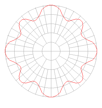 | ||||||||||||||||||
| Azimuth | Ratio | Azimuth | Ratio | Azimuth | Ratio | Azimuth | Ratio | ||||||||||||
| 0 | 1.000 | 10 | 0.947 | 20 | 0.793 | 30 | 0.756 | ||||||||||||
| 40 | 0.902 | 45 | 0.933 | 50 | 0.902 | 60 | 0.756 | ||||||||||||
| 70 | 0.793 | 80 | 0.947 | 90 | 1.000 | 100 | 0.947 | ||||||||||||
| 110 | 0.793 | 120 | 0.756 | 130 | 0.902 | 135 | 0.933 | ||||||||||||
| 140 | 0.902 | 150 | 0.756 | 160 | 0.793 | 170 | 0.947 | ||||||||||||
| 180 | 1.000 | 190 | 0.947 | 200 | 0.793 | 210 | 0.756 | ||||||||||||
| 220 | 0.902 | 225 | 0.933 | 230 | 0.902 | 240 | 0.756 | ||||||||||||
| 250 | 0.793 | 260 | 0.947 | 270 | 1.000 | 280 | 0.947 | ||||||||||||
| 290 | 0.793 | 300 | 0.756 | 310 | 0.902 | 315 | 0.933 | ||||||||||||
| 320 | 0.902 | 330 | 0.756 | 340 | 0.793 | 350 | 0.947 | ||||||||||||
Structure Registration Number 1028073 Structure Type: TOWER Registered To: REDWOOD FALLS TV IMPROVEMENT CORPORATION Structure Address: 0.8 Km East Morton, MN County Name: Renville County ASR Issued: 02/23/2000 Date Built: 01/01/1957 Site Elevation: 306.3 m (1005 ft.) Structure Height: 137.2 m (450 ft.) Height Overall: 137.2 m (450 ft.) Overall Height AMSL: 443.5 m (1455 ft.) FAA Determination: 12/23/1999 FAA Study #: 99-AGL-5348-OE Paint & Light FAA Chapters: 1, 3, 4, 13, 21 PRIOR FAA # 83-AGL-1005-OE CONTINUE OM&L PAINT/RED LIGHTS 44-32-58.9 N 94-58-01.0 W (NAD 83) 44-32-59.0 N 94-58-00.0 W (Converted to NAD 27) |
P.o. Box 120 Morton, MN 56270 Phone: 507-697-6489 Not-for-Profit | Title: President Date: 11/09/2018 Application Certifier REDWOOD TV IMPROVEMENT CORPORATION Redwood Tv Improvement Corporation P.o. Box 120 Morton, MN 56270 Applicant Susan Hansen B. W. St. Clair 6868 Vivian St. Arvada, CO 80004 Consultant TOM UPPMAN Uppman Technical Services, Inc. 27408 Scenic Byway Road Belle Plaine, MN 56011 | |||||||||||||||||