
FCCInfo.com
A Service of Cavell, Mertz & Associates, Inc.
(855) FCC-INFO
|
|
K51AL-D from 11/13/2018 K51AL-D from 02/22/2012 |
|
|
||||||||||||||||
|
|
Status: License Application Accepted: 11/09/2018 License Expires: 04/01/2022 File Number: -0000063422 FCC Website Links: LMS Facility Details This Application Other K34OZ-D Applications Including Superseded Applications Mailing Address Correspondence for K34OZ-D Correspondence related to application -0000063422 Service Contour - Open Street Map or USGS Map (51 dBu) Service Contour - KML / Google Earth (51 dBu) Rabbit Ears Info Search for K34OZ-D Site Location: 44-45-32.9 N 94-52-24.0 W (NAD 83) Site Location: 44-45-33.0 N 94-52-23.0 W (Converted to NAD 27) ERP: 0.79 kW Polarization: Horizontally polarized R/C AGL: 91.4 m (300 ft.) R/C AMSL: 423.9 m (1391 ft.) Emission Mask: Stringent Site Elevation: 332.5 m. (1091 ft.) Height Overall*: 152.4 m (500 ft.) (* As Filed In This Application, may differ from ASR Data, Below.) Directional Antenna - Antenna Make/Model: Scala 4X2KBBU Antenna ID: 20756 Polarization: Horizontally polarized
| ||||||||||||||||||
| Antenna Data for Antenna Id: 20756 K34OZ-D LD File: -0000063422 Scala - 4X2KBBU Service: LD Standard Pattern: Y Pattern and Field Values Include a 220° Clockwise Rotation | 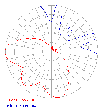 | ||||||||||||||||||
| Azimuth | Ratio | Azimuth | Ratio | Azimuth | Ratio | Azimuth | Ratio | ||||||||||||
| 0 | 0.065 | 10 | 0.116 | 20 | 0.051 | 30 | 0.043 | ||||||||||||
| 40 | 0.069 | 50 | 0.043 | 60 | 0.051 | 70 | 0.116 | ||||||||||||
| 80 | 0.065 | 90 | 0.089 | 100 | 0.131 | 110 | 0.202 | ||||||||||||
| 120 | 0.316 | 130 | 0.432 | 140 | 0.570 | 150 | 0.738 | ||||||||||||
| 160 | 0.931 | 170 | 1.000 | 180 | 0.955 | 190 | 0.813 | ||||||||||||
| 200 | 0.717 | 210 | 0.846 | 220 | 0.931 | 230 | 0.846 | ||||||||||||
| 240 | 0.717 | 250 | 0.813 | 260 | 0.955 | 270 | 1.000 | ||||||||||||
| 280 | 0.931 | 290 | 0.738 | 300 | 0.570 | 310 | 0.432 | ||||||||||||
| 320 | 0.316 | 330 | 0.202 | 340 | 0.131 | 350 | 0.089 | ||||||||||||
Structure Registration Number 1209827 Structure Type: TOWER Registered To: RENVILLE COUNTY TV CORPORATION Structure Address: 1.6 Km Ese Bird Island, MN County Name: Renville County ASR Issued: 02/23/2000 Date Built: 04/15/1975 Site Elevation: 332.5 m (1091 ft.) Structure Height: 152.4 m (500 ft.) Height Overall: 152.4 m (500 ft.) Overall Height AMSL: 484.9 m (1591 ft.) FAA Determination: 12/23/1999 FAA Study #: 99-AGL-6008-OE Paint & Light FAA Chapters: 1, 3, 4, 13, 21 PRIOR FAA # 99-TR-OOOO-OE CONTINUE OM&L PAINT/RED LIGHTS 44-45-32.9 N 94-52-24.0 W (NAD 83) 44-45-33.0 N 94-52-23.0 W (Converted to NAD 27) |
P. O. Box 312 Olivia, MN 56277 Phone: 507-697-6489 Not-for-Profit | Title: President Date: 11/09/2018 Application Certifier RENVILLE CNTY TV CORPORATION Renville Cnty Tv Corporation P. O. Box 312 Olivia, MN 56277 Applicant Tom Uppman Uppman Technical 27408 Scenic Byway Road Belle Plaine,, MN 56011 | |||||||||||||||||